Denman Prospect, Australian Capital Territory

Last updated

Denman Prospect
Canberra,  Australian Capital Territory
Denman Village shops March 2020.jpg
The Denman Village shopping centre in 2020
Australia Capital Territory location map.svg
Red pog.svg
Denman Prospect
Coordinates 35°18′11″S149°01′26″E / 35.303°S 149.024°E / -35.303; 149.024
Population2,759 (SAL 2021) [1]
Gazetted 14 June 2012 [2]
Postcode(s) 2611
Area1.07 km2 (0.4 sq mi)
Location10 km (6 mi) W of Canberra City
District Molonglo Valley
Territory electorate(s) Murrumbidgee
Federal division(s) Bean
Website Denman Prospect
Suburbs around Denman Prospect:
Whitlam Molonglo
Denman Prospect Molonglo
Wright Coombs

Denman Prospect is a suburb currently under development in the Molonglo Valley district of Canberra, located within the Australian Capital Territory, Australia.

Contents

It is named in honour of Lady Denman, [3] the wife of the fifth Governor-General of Australia, The Lord Denman. The principal ceremonial occasion during Lady Denman's term as first lady was the inauguration of the Federal capital on 12 March 1913. Lady Denman stood upon the newly laid Foundation Stones and pronounced, "I name the capital of Australia – Canberra". The name Denman Prospect was selected to distinguish the locality from the town of Denman, New South Wales. The use of the suffix 'prospect' meaning view, vision or the outlook for the future, is considered significant in the context of the naming of Canberra by Lady Denman and Lord Denman's ensuing visionary speech for the future of the capital. [2]

The streets of Denman Prospect are named after activists and reformers. [4]

History

Denman Prospect in May 2020 Houses in Denman Prospect May 2020.jpg
Denman Prospect in May 2020

The ACT government attempted to sell the entire suburb as one lot to a developer first at an auction, and then by negotiation. However the Colliers auction on 12 April 2013 was a failure with only one registered bidder, and then three months of negotiating led nowhere, and so the Land Development Agency will now develop the suburb itself. [5] Blame for the failure to sell to a developer was placed on new solar access regulations, which meant that blocks had to be bigger, or that house sites had to be excavated into the hillside. [6] Denman Prospect was scheduled to be the third suburb to be developed in the Molonglo Valley District and the first in stage 2. [7] In July 2015 the Capital Estate Development company won a tender to build half of the suburb. This company is owned by the Snow family who also own Canberra Airport. [8]

Coppins Crossing bridge was repaired after flooding in 2011. [9]

Location and urban structure

Denman Prospect is located to the north of Uriarra Road, west of John Gorton Drive and south of the Molonglo River. Topographically it is north east of Mount Stromlo with a series of valleys draining eastwards towards the Molonglo River in the south of the suburb, and the north east direction in the north. The highest points of the suburb are along hills on the eastern side at just over 654 metres high. Uriarra Road is about 630 m above sea level. The lowest point is on the Molonglo River just below 499 m above sea level. This makes Denman Prospect the lowest Canberra suburb. [10]

The land area is 107 hectares and will contain 1700 dwellings if fully developed. [11] There will be a local centre and two schools. [11]

Coppins Crossing Road between Uriarra Road and William Hovell Drive has a long history prior to the development of Molonglo, but it will be replaced by John Gorton Drive.

Wildlife

The rare pink tailed worm lizard is found near the Molonglo River. [12] The butterfly Ogyris amaryllis amata occurs near Coppins Crossing. [13] Denman Prospect has been declared a cat containment area where cats are not permitted to roam freely. [14]

Geology

Coppins Crossing in 2020 Coppins Crossing May 2020.jpg
Coppins Crossing in 2020

The suburb of Denman Prospect is split by an east–west direction fault that splays off the Winslade Fault just to the west of the suburb. This fault is marked by quartz. The south side of the fault has been thrown down, and the north side elevated. The north-east heading Winslade Fault itself cuts off the northern tip of the suburb. To the north of the fault are the Mount Painter Volcanics in the north east with tuff composed of dacite fragments and underlying Walker Volcanics in the north west. Mount Painter Volcanics are of late Wenlock age. The rock south of the east–west fault is younger than the rocks to the north. Rocks in the south are rhyodacite from the Deakin Volcanics, and on the far west side of the suburb is ignimbrite and shale from the Laidlaw Volcanics. The Laidlaw Volcanics are the latest in the sequence and are 420.7±2.2 million years old. A sand quarry used to be worked just to the west of Coppins Crossing on the Denman Prospect side of the Molonglo River. [15]

Related Research Articles

<span class="mw-page-title-main">Fyshwick, Australian Capital Territory</span> Retail and light industry suburb of Canberra, Australia

Fyshwick is a retail and light industrial suburb of Canberra, Australia, east of the South Canberra district. At the 2016 census, Fyshwick had a population of 56.

<span class="mw-page-title-main">Molonglo River</span> River in Australia

The Molonglo River is a perennial river that is part of the Murrumbidgee catchment within the Murray–Darling basin. It is located in the Monaro and Capital Country regions of New South Wales and the Australian Capital Territory, in Australia.

<span class="mw-page-title-main">Weston Creek</span> Place in Australian Capital Territory

Weston Creek is a district in the Australian Capital Territory in Australia. The district is subdivided into divisions (suburbs), sections and blocks. The district comprises eight residential suburbs, situated to the west of the Woden Valley district and approximately 13 kilometres (8.1 mi) southwest of the Canberra City centre. Situated adjacent to the district was the large Stromlo Forest pine plantation until the forest was destroyed by bushfires in 2001 and 2003.

<span class="mw-page-title-main">Charnwood, Australian Capital Territory</span> Suburb of Canberra, Australian Capital Territory

Charnwood is a suburb in the Belconnen district of Canberra located within the Australian Capital Territory, Australia.

<span class="mw-page-title-main">Belconnen, Australian Capital Territory</span> Suburb of Canberra, Australian Capital Territory

Belconnen is the most inner suburb of the larger district of Belconnen in Canberra, Australia. Sharing its name with the larger district which encapsulates it, the suburb is surrounded with well developed infrastructure, and planning which allows it sunset views from the Brindabellas on its western side. The suburb contains important amenities for the District of Belconnen including the Belconnen Town Centre and Lake Ginninderra as well as its own well populated residential areas. It is bounded by Ginninderra Drive, Aikman Drive, Eastern Valley Way, Belconnen Way and Coulter Drive. It has a number of parks such as Margaret Timpson Park, Eastern Valley Oval and on the foreshores of Lake Ginninberra, Diddams Close Park and John Knight Memorial Park.

<span class="mw-page-title-main">Kaleen</span> Suburb of Canberra, Australian Capital Territory

Kaleen is a suburb in the Belconnen district of Canberra, located within the Australian Capital Territory, Australia. The suburb's name is derived from the word for 'water' in the language of the Wiradjuri Aboriginal tribe of the central west region of New South Wales. Kaleen was gazetted as a suburb on 15 January 1974. The streets are named after Australian rivers.

<span class="mw-page-title-main">Weetangera, Australian Capital Territory</span> Suburb of Canberra, Australian Capital Territory

Weetangera is a suburb in the Belconnen district of Canberra, located within the Australian Capital Territory, Australia. The suburb covers an area of approximately 158 hectares. Located approximately 10 kilometres (6.2 mi) north-west of the city, Weetangera is bounded by Springvale Drive to the south and west, Coulter Drive to the east and Belconnen Way to the north. The Pinnacle Nature Reserve, a Canberra Nature Park is adjacent to the south of the suburb, across Springvale Drive.

<span class="mw-page-title-main">Palmerston, Australian Capital Territory</span> Suburb of Canberra, Australian Capital Territory

Palmerston is a suburb in the Canberra, Australia district of Gungahlin. The postcode is 2913. The suburb is named after George Thomas Palmer (1784–1854) who established a settlement in the Canberra region in 1826 called Palmerville, which was later renamed Ginninderra. It was gazetted on 20 March 1991. Streets are named after mountains and mountain ranges of Australia, with the main street called Kosciuszko Avenue. It is next to the suburbs of Nicholls, Gungahlin, Crace and Franklin. It was the second suburb to be developed in the Gungahlin district, after the industrial suburb of Mitchell. It is bounded by Gungahlin drive and Gundaroo drive.

Uriarra Village is a town in the district of Coree, in the Australian Capital Territory in Australia. It is situated on the western side of the Australian Capital Territory, about 30 minutes from Canberra, established in 1928 at the foothills of the Australian Alps. A nearby area to the north of the border in New South Wales is also called Uriarra.

<span class="mw-page-title-main">Tuggeranong Parkway</span> Road in Canberra, Australia

Tuggeranong Parkway is an 11-kilometre-long (6.8 mi) major highway in Canberra, Australia. Often referred to as "The Parkway" by locals, Tuggeranong Parkway links Civic to the southern Canberra metro district of Tuggeranong, and is a bypass road to the Woden Valley-Weston Creek district of Canberra. It also links to the Glenloch Interchange, where roads such as Caswell Drive connect to Belconnen.

<span class="mw-page-title-main">Mount Stromlo</span> Mountain in the Australian Capital Territory

Mount Stromlo is a mountain with an elevation of 770 metres (2,530 ft) AHD  that is situated in the Australian Capital Territory, Australia. The mountain is most notable as the location of the Mount Stromlo Observatory. The mountain forms part of the catchment area of the Cotter River which in turn is the primary water supply for part of ACT.

<span class="mw-page-title-main">Geology of the Australian Capital Territory</span> Overview of the geology of the Australian Capital Territory

The geology of the Australian Capital Territory includes rocks dating from the Ordovician around 480 million years ago, whilst most rocks are from the Silurian. During the Ordovician period the region—along with most of eastern Australia—was part of the ocean floor. The area contains the Pittman Formation consisting largely of Quartz-rich sandstone, siltstone and shale; the Adaminaby Beds and the Acton Shale.

<span class="mw-page-title-main">Scrivener Dam</span> Dam in Canberra, ACT

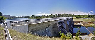
Scrivener Dam is a concrete gravity dam that impounds the Molonglo River in Canberra, Australian Capital Territory. The dam creates Lake Burley Griffin, which was established for recreational and ornamental purposes. Named in honour of surveyor Charles Scrivener, the dam was officially inaugurated on 20 September 1963 and the official filling of the lake commemorated on 17 October 1964 by the Prime Minister, Robert Menzies.

<span class="mw-page-title-main">Canberra Central</span> Place in Australian Capital Territory

Canberra Central is a district in the Australian Capital Territory in Australia. Consisting of both the subdivisions of North Canberra and South Canberra. The district is subdivided into divisions (suburbs), sections and blocks. The district of Canberra Central lies entirely within the bounds of the city of Canberra, the capital city of Australia.

<span class="mw-page-title-main">Molonglo Valley</span> Place in Australian Capital Territory

Molonglo Valley is a district in the Australian Capital Territory in Australia. Is the only district that was not created in 1966. The district is subdivided into divisions (suburbs), sections and blocks and is the newest district of the ACT. The district is planned to consist of thirteen suburbs, planned to contain 33,000 dwellings, with an expected population of between 50,000 and 73,000. To be developed in three stages over more than ten years, the district will contain a principal town centre and a secondary group centre, with residential suburbs located to the south and north of the Molonglo River; located to the west of Lake Burley Griffin.

Molonglo is a suburb currently under development in the Molonglo Valley district of Canberra, Australian Capital Territory, Australia. The suburb of Molonglo derives its name from an Aboriginal expression meaning "the sound of thunder".

Coombs is a suburb currently under development in the Molonglo Valley district of Canberra, located within the Australian Capital Territory, Australia. It is named in honour of H. C. "Nugget" Coombs, a prominent public servant, economist, and the first Governor of the Reserve Bank of Australia. Streets and public places in Coombs are named with the theme of persons notable for public service.

<span class="mw-page-title-main">Jerrabomberra (district)</span> Place in Australian Capital Territory

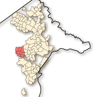
Jerrabomberra is a district in the Australian Capital Territory in Australia. It is situated to the southeast of Canberra Central, south of the Molonglo River, east of Woden Valley and north east of Tuggeranong and west of the New South Wales border. It includes the suburbs of Beard, Hume, Oaks Estate and Symonston and the military communications and logistics facility HMAS Harman. At the 2016 census, it had a total population of 1,240, comprising 559 in Symonston, 430 in Hume and 251 in Oaks Estate and Beard At the 2011 census, 13 also lived in Harman. It is named after Jerrabomberra Creek, which runs through it, Jerrabomberra is derived from the Aboriginal word, meaning "afraid of lightning".

Whitlam is a suburb in the Molonglo Valley, Australian Capital Territory. The suburb is named after former prime minister Gough Whitlam. Many Canberra suburbs are named after prime ministers or other politicians, but only at least a year post death. The ACT government waited a year before announcing a suburb named Whitlam. Whitlam is the northernmost suburb in the Molonglo Valley district, positioned to the north of Denman Prospect.

References

  1. Australian Bureau of Statistics (28 June 2022). "Denman Prospect (suburb and locality)". Australian Census 2021 QuickStats. Retrieved 28 June 2022.  OOjs UI icon edit-ltr-progressive.svg
  2. 1 2 "Search for street and suburb names: Denman Prospect". Environment and Sustainable Development Directorate . ACT Government. 4 December 2013. Archived from the original on 24 December 2013. Retrieved 22 December 2013.
  3. Sharaz, David (15 June 2012). "Denman Prospect and Molonglo: our newest suburbs". The Canberra Times . Retrieved 22 December 2013.
  4. Gentleman, Mick (25 July 2017). "Denman prospect street names honour activists" (Press release). ACT government. Retrieved 10 January 2022.
  5. Anderson, Stephanie; Meredith Clisby (12 September 2013). "Debate over Denman Prospect's development continues". The Canberra Times. Retrieved 23 December 2013.
  6. Clisby, Meredith (29 June 2013). "Solar rules blamed for Denman fail". The Canberra Times. Retrieved 23 December 2013.
  7. "New suburb gets ready for auction". 20 January 2013. Retrieved 23 December 2013.
  8. "Family behind Canberra Airport set to build half of ACT's newest suburb Denman Prospect". ABC News. 28 July 2015. Retrieved 22 March 2020.
  9. "Bridge 4096 – Coppins Crossing, ACT". Hawkins Civil. 23 June 2011. Retrieved 24 December 2013.
  10. "ACTMAPi Imagery Viewer with 2004 contours". Archived from the original on 23 December 2013. Retrieved 22 July 2019.
  11. 1 2 "Denman Prospect a Unique Opportunity for Developers" (PDF). ACT Government Land Development Agency. 20 December 2012. Archived from the original (PDF) on 3 May 2013. Retrieved 23 December 2013.
  12. "Flora and Fauna: Pink Tailed Worm Lizard" . Retrieved 24 December 2013.
  13. Braby, Michael (2000). Butterflies of Australia: Their Identification, Biology and Distribution. Csiro Publishing. p. 908. ISBN   9780643102927.
  14. "Geocortex Viewer for HTML5". app.actmapi.act.gov.au.
  15. Henderson G A M and Matveev G, Geology of Canberra, Queanbeyan and Environs 1:50000 1980.