Deux Jumeaux Airfield

Last updated
Deux Jumeaux Airfield
Advanced Landing Ground (ALG) A-4
Calvados, Basse-Normandie Region, France
Deux Jumeaux Airfield - A4.jpg
Remains of Deux Jumeaux Airfield after dismantling
France location map-Regions and departements-2016.svg
Red pog.svg
Deux Jumeaux Airfield
Coordinates 49°20′52″N000°58′50″W / 49.34778°N 0.98056°W / 49.34778; -0.98056 (A-4 Deux-Jumeaux) Coordinates: 49°20′52″N000°58′50″W / 49.34778°N 0.98056°W / 49.34778; -0.98056 (A-4 Deux-Jumeaux)
TypeMilitary Airfield
Site information
Controlled by Us army air corps shield.svg United States Army Air Forces
Site history
Built byIX Engineering Command
In useJune–September 1944
MaterialsSquare-Mesh Track (SMT)
Battles/wars European-African-Middle Eastern Campaign Streamer.jpg
World War II - EAME Theater
  • Normandy Campaign
  • Northern France Campaign
Garrison information
Garrison Patch9thusaaf.png   Ninth Air Force
Occupants
  • 48th Fighter Group
Airfield information
Runways
Direction Length and surface
11/291,500 m (4,900 ft) SMT/PSP
One runway, 4 alert pads, 50 hardstands [1]
P-47 Thunderbolts of the 48th Fighter Group line up for take off at Deux Jumeaux Airfield 48th Fighter Group P-47Ds taking off at Deux Jumeaux Airfield A-4.jpg
P-47 Thunderbolts of the 48th Fighter Group line up for take off at Deux Jumeaux Airfield

Deux Jumeaux Airfield is an abandoned World War II military airfield, which is located near the commune of Deux Jumeaux in the Normandy region of northern France.

Contents

Located just outside of Deux Jumeaux, the United States Army Air Force established a temporary airfield on 14 June 1944, shortly after the Allied landings in France. The airfield was one of the first established in the liberated area of Normandy, being constructed by the IX Engineering Command, 816th Engineer Aviation Battalion.

History

Known as Advanced Landing Ground "A-4", the airfield consisted of a single 5000' (1500m) Square-Mesh Track runway aligned 11/29. In addition, with tents were used for billeting and also for support facilities; an access road was built to the existing road infrastructure; a dump for supplies, ammunition, and gasoline drums, along with a drinkable water and minimal electrical grid for communications and station lighting. [2]

The fighter planes flew support missions during the Allied invasion of Normandy, patrolling roads in front of the beachhead; strafing German military vehicles and dropping bombs on gun emplacements, anti-aircraft artillery and concentrations of German troops in Normandy and Brittany when spotted.

The main unit using Deux Jummeaux airfield was the 48th Fighter Group, however, it was also used by the P-38 Lightnings of the 485th Squadron of the 370th Fighter Group from RAF Andover in Hampshire, England in late July 1944. The lack of airfields built in France led to a lack of space at the beginning of the Battle of Normandy. The staff of the 9th Air Force, under pressure from SHAEF to "explode" the sacred unity of the Group to send squadrons in different fields already well established. [1]

After the Americans moved east into Central France with the advancing Allied Armies, the airfield was left un-garrisoned and used for resupply and casualty evacuation. It was closed on 15 September 1944 and the land returned to agricultural use. [3]

Major units assigned

492d (F4), 493d (I7), 494th (6M) Fighter Squadrons (P-47D) [4]

Current use

Today the airfield is a mixture of various agricultural fields. A memorial to the men and units that were stationed at Deux Jumeaux was placed near the site of the former airfield. It is located to the east of La Cambe along the D204, 340 meters north of the bridge on the N13.

See also

Related Research Articles

Deux-Jumeaux Commune in Normandy, France

Deux-Jumeaux is a commune in the Calvados department in the Normandy region in northwestern France.

Cricqueville Airfield

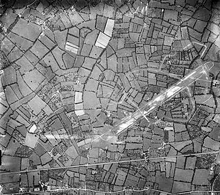
Cricqueville en Bessin Airfield is an abandoned World War II military airfield, which is located near the commune of Cricqueville-en-Bessin in the Normandy region of northern France.

Saint-Pierre-du-Mont Airfield

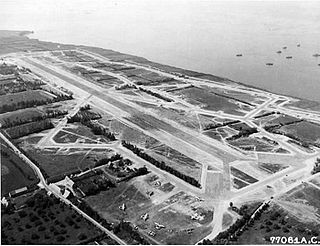
Saint-Pierre-du-Mont Airfield is an abandoned World War II military airfield which is located in the Calvados department in the Normandy region in northern France. It was one of the many instrumental airfields used to defeat Adolf Hitler's Axis powers in World War II.

Carentan Airfield

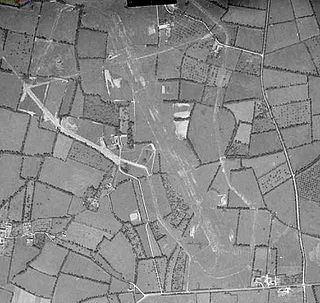
Carentan Airfield is an abandoned World War II military airfield, which is located near the commune of Carentan in the Normandy region of northern France.

Picauville Airfield

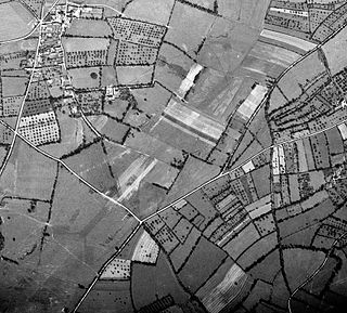
Picauville Airfield is an abandoned World War II military airfield, which is located near the commune of Picauville in the Normandy region of northern France.

Azeville Airfield

Azeville/Fontenay (Azeville) Airfield is an abandoned World War II military airfield, which is located near the commune of Azeville in the Normandy region of northern France.

Beuzeville Airfield

Beuzeville/Ste Mère Eglise (Beuzeville) Airfield is an abandoned World War II military airfield, which is located near the commune of Beuzeville-au-Plain in the Normandy region of northern France.

Chippelle Airfield

Chippelle à Cartigny-L’Épinay (Chippelle) Airfield is an abandoned World War II military airfield, which is located near the commune of Cartigny-l'Épinay in the Calvados in the Normandy region of northern France ·.

Cardonville Airfield World War II military airfield

Cardonville Airfield is an abandoned World War II military airfield located near the commune of Cardonville in the Normandy region of northern France.

La Vieille Airfield is an abandoned World War II military airfield, which is located in the commune of Saint Georges d'Elle in the Normandy region of northern France.

Saint-Lambert Airfield

Saint-Lambert Airfield is an abandoned World War II military airfield, which is located near the commune of Saint-Lambert in the Normandy region of northern France.

Meautis Airfield is an abandoned World War II military airfield, which is located near the commune of Méautis in the Normandy region of northern France.

Lignerolles Airfield

Lignerolles Airfield is an abandoned World War II military airfield near the commune of Lignerolles in the Normandy region of northern France.

Brucheville Airfield

Brucheville Airfield is an abandoned World War II military airfield, which is located near the commune of Brucheville in the Normandy region of northern France.

Cretteville Airfield

Cretteville Airfield is an abandoned World War II military airfield, which is located near the commune of Cretteville in the Normandy region of northern France.

Tour-en-Bessin Airfield

Tour-en-Bessin Airfield is a now-abandoned World War II military airfield near the commune of Tour-en-Bessin in the Normandy region of northern France.

Pontorson Airfield is an abandoned World War II military airfield, which is located near the commune of Pontorson in the Normandy region of northern France.

Saint James Airfield is an abandoned World War II military airfield, which is located near the commune of Saint-James in the Lower Normandy region of northern France.

Gael Airfield

Gael Airfield is an abandoned World War II military airfield, which is located near the commune of Gaël in the Brittany region of northern France.

Saint Marceaul Airfield is an abandoned World War II military airfield, which is located near the commune of Saint-Marceau in the Pays de la Loire region of northern France.

References

PD-icon.svg This article incorporates  public domain material from the Air Force Historical Research Agency website http://www.afhra.af.mil/ .

  1. 1 2 Deux Jumeaux Airfield
  2. "IX Engineer Command ETO Airfields, Airfield Layout". Archived from the original on 2008-08-20. Retrieved 2009-09-21.
  3. Johnson, David C. (1988), U.S. Army Air Forces Continental Airfields (ETO), D-Day to V-E Day; Research Division, USAF Historical Research Center, Maxwell AFB, Alabama.
  4. Maurer, Maurer. Air Force Combat Units of World War II. Maxwell AFB, Alabama: Office of Air Force History, 1983 ISBN   0-89201-092-4