Related Research Articles

Tirana is the capital and largest city of Albania. It is located in the centre of the country, enclosed by mountains and hills, with Dajti rising to the east and a slight valley to the northwest overlooking the Adriatic Sea in the distance. It is among the wettest and sunniest cities in Europe, with 2,544 hours of sun per year.

Tirana County, officially the County of Tirana, is a county in the Central Region of Albania. It is the tenth largest by area and the most populous of the twelve counties, with more than 912,000 people within an area of 1,652 km2 (638 sq mi). The county borders on the Adriatic Sea to the west, the counties of Durrës to the northwest, Dibër to the northeast, Elbasan to the east and Fier to the southwest. It is divided into five municipalities, Tirana, Kamëz, Kavajë, Rrogozhinë and Vorë, with all of whom incorporate twenty-nine administrative units.
The first neighborhood in Tirana was Bam. The three oldest neighborhoods are Mujos, and Pazari located between the geographical centre and Elbasan Street on either side of the Lanë, and Brraka located east of Zog I Boulevard around modern Haxhi Hysen Dalliu Street.

The Palace of Culture of Tirana was built on the Pazari i Vjeter area of Tirana by request of Enver Hoxha. For this construction, both the old bazaar and the historic mosque of Mahmud Muhsin Bey Stërmasi were destroyed under the rulership of the Albanian Labour Party in adherence to the communist country's declaration of state atheism. The Ottoman mosque had been built from 1837 to 1840 and had a tiled roof as well as a striking minaret with a sherefe.
Laprakë is a neighbourhood of Tirana, Albania, located west of the main centre. It is mainly a residential district, but also contains the Tirana Military Hospital, the Albanian Mobile Communications building, the ProCredit Bank building and several other high-rise buildings, a football pitch, and a petrol station.

Durrës railway station is the main railway station serving the port city of Durrës in central Albania, the second most populous city of the Republic of Albania. It is located in the city centre, near the local port, at the intersection of Rruga Adria and Rruga Egnatia. There is also a station for intercity buses in front of the railway station building. The station is the hub of the Albanian railway network, and is connected by rail to other cities in Albania, including the capital of Tirana, Vlorë, Elbasan and Shkodër. It is located in the city centre, close to the Port of Durrës.

Kavajë Street is a major street of Tirana, Albania. It is the most important street of western Tirana and runs west from the central Skanderbeg Square for several kilometres and continues further west to the Adriatic Sea. It is known for its prime real estate and some of the most expensive residential apartments in Tirana. The Universal Hospital Tirana is located along this street. It intersects with Bajram Curri Boulevard.
Ali Demi Street is a major street of Tirana, Albania. It is named after Ali Demi, a World War II hero. It is an important central street of eastern Tirana and branches off the Bajram Curri Boulevard. Several universities and colleges are located along this street. In this street is located the Ministry of Foreign Affairs.
Zhan D'Ark Boulevard is a boulevard of Tirana, Albania. It runs along the north bank of the river Lanë. It was named after the French heroine Joan of Arc. Until recently, it held the name Rruga Marsel Kashen in honor of the French politician Marcel Cachin. The boulevard, along with Bajram Curri Boulevard which runs parallel to it, underwent reconstruction in 2003.

The Tanners' Bridge is an 18th-century Ottoman period stone footbridge located in Tirana, Albania. The bridge, built near the Tanners' Mosque, was once part of the Saint George Road that linked Tirana with the eastern highlands. The road was the route by which livestock and produce entered the city. The bridge crossed the Lanë stream near the area where butcher shops and leather workers were located. The bridge fell into disrepair when the Lanë was diverted in the 1930s. In the 1990s, the bridge was restored for use by pedestrians.
Pjetër Budi Street is a street in Tirana, the capital of Albania. It is named after Pjetër Budi, a 17th-century bishop in the district of Shkodër. It is the main road leading to the Student City and although there are often no sidewalks it is a major pedestrian thoroughfare. It is also where much of the student protests of 1990 began, which gave rise to widespread riots in four of the largest cities in northern Albania.

Elbasan Street is a major street of Tirana, Albania. It is the most important street of southern Tirana leading to national road SH3 and European Route E852. It eventually leads to Elbasan. The US Embassy in Tirana and the Jordan Misja Artistic Lyceum are located on Elbasan Street.

Durrës Street is a major street of Tirana, Albania. It is one of the most important street of western Tirana and runs west from the central Skanderbeg Square for several kilometres until it reaches the sea to the north of Durrës.

Rinia Park is the central public park of Tirana, Albania. Built in 1950 during the communist era, it covers an area of 2.98 hectares.
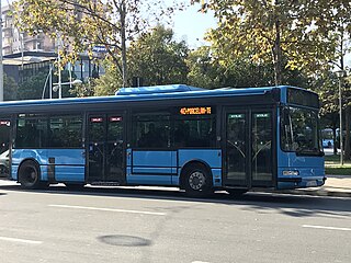
The Bus lines in Tirana refer to the bus lines operated by both private and public companies in Tirana, Albania. Despite the introduction of relatively new buses, passengers experience overcrowding and intermittent use of air conditioning on board.
The Prison Hospital of Tirana is a prison in Tirana, Albania. It was established in 1930. It was closed under the Communist regime, but was reopened in 1998.

The Albanian State Road 2 (SH2), is a dual carriageway in Albania linking the port city of Durrës with the metropolis and the capital Tirana. The road was the first highway to be reconstructed in Albania, following the Fall of Communism in 1991.
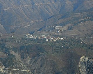
Krastë is a small town in Dibër County, east Albania. With a population of 2142, it is the center and only town of the municipal unit of Martanesh. At the 2015 local government reform it became part of the municipality Bulqizë. Situated on a plateau, at 1,100 m (3,609 ft) altitude, it is Albania's highest town. Krastë was founded as a new mining town in 1970, mostly for the exploitation of chromium ore from the Batra mine.

The National Road 6 leads from Milot to Peshkopi.
References
- ↑ Jeroen van Marle, Alwyn Thomson, Tirana In Your Pocket, p.20
| Geography | |||||||||||
|---|---|---|---|---|---|---|---|---|---|---|---|
| Economy | |||||||||||
| Politics | |||||||||||
| Infrastructure |
| ||||||||||
| Education |
| ||||||||||
| Health | |||||||||||
| Structures | |||||||||||
| Culture |
| ||||||||||
41°19′46″N19°49′10″E / 41.32944°N 19.81944°E
| | This article about a specific location in Tirana County, Albania, is a stub. You can help Wikipedia by expanding it. |
| | This European road or road transport-related article is a stub. You can help Wikipedia by expanding it. |
| | This article about transport in Albania is a stub. You can help Wikipedia by expanding it. |