Dieterode

Last updated
Dieterode
Wappen Dieterode.png
Location of Dieterode within Eichsfeld district
Dieterode in EIC.svgBrehmeEffelderFreienhagenGernrodeKellaKellaKrombachLutterMackenrodeMarthRohrbergSchönhagenSteinbachSonnensteinWiesenfeld
Germany adm location map.svg
Red pog.svg
Dieterode
Thuringia location map.svg
Red pog.svg
Dieterode
Coordinates: 51°17′51″N10°6′6″E / 51.29750°N 10.10167°E / 51.29750; 10.10167 Coordinates: 51°17′51″N10°6′6″E / 51.29750°N 10.10167°E / 51.29750; 10.10167
Country Germany
State Thuringia
District Eichsfeld
Municipal assoc. Ershausen/Geismar
Government
   Mayor (202228) Uwe Günther [1]
Area
  Total2.79 km2 (1.08 sq mi)
Elevation
403 m (1,322 ft)
Population
 (2020-12-31) [2]
  Total77
  Density28/km2 (71/sq mi)
Time zone UTC+01:00 (CET)
  Summer (DST) UTC+02:00 (CEST)
Postal codes
37318
Dialling codes 036082
Vehicle registration EIC
Website www.ershausen-
geismar.de
View of 'Dieterode and its former railway station' Dieterode im Eichsfeld.jpg
View of 'Dieterode and its former railway station'

Dieterode is a municipality in the district Eichsfeld, Thuringia, Germany. It is part of the municipal association Ershausen/Geismar.

Contents

Situation

Dieterode, is situated eight kilometers south west of Heilbad Heiligenstadt between Höheberg and Rachelsberg. Neighbouring communities are Kalteneber (north east), Rüstungen, Schwobfeld (to the south) and Eichstruth (to the west).

History

The place is said to be firstly mentioned 1184 or 1251 as "Diethenroth". [3] The church, built in 1520, was newly built in 1785. In 1914, railway reached Dieterode. (Schwebda). Due to Inner German border closing, railway traffic ended in 1947. The rails were dismantled.

Demography

Population (31. December):
YearInhabitants
1994100
1995100
1996100
1997102
1998107
1999107
2000104
YearInhabitants
2001105
2002105
2003104
2004103
2005104
200699
200794
YearInhabitants
200893
200992
201092
201176
201274
201375
201474
Source: Thüringian Statistics Office

Politics

Community council

The Dieterode community council comprises 6 members.

The election proposal list of FFw (FFw = Voluntary Fire brigade) won all 6 seats (Date: 7. Juni 2009) [4]

Mayor

The (voluntary) mayor Uwe Günther (FFw) was first elected in 1994, and re-elected in 1999, 2004, 2010 and 2016. [5] [6]

Tourist attractions

Hoheberg and Dieteroder Klippen seen from Dieterode Hoheberg mit Dieteroder Klippen.JPG
Höheberg and Dieteröder Klippen seen from Dieterode

Related Research Articles

<span class="mw-page-title-main">Geismar</span> Municipality in Thuringia, Germany

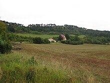
Geismar is a municipality in the district of Eichsfeld in Thuringia, Germany.

<span class="mw-page-title-main">Uder</span> Municipality in Thuringia, Germany

Uder is a municipality in the district of Eichsfeld in Thuringia, Germany.

<span class="mw-page-title-main">Tanna, Germany</span> Town in Thuringia, Germany

Tanna is a city in Thuringia, in the district of Saale-Orla-Kreis. It is located about 10 km south of Schleiz. Tanna was founded in 1495. The musicologist Paul Willert (1901–1988) was born in the city.

<span class="mw-page-title-main">Bad Köstritz</span> Town in Thuringia, Germany

Bad Köstritz is a town in the district of Greiz, in Thuringia, Germany. It is situated on the White Elster river, 7 km northwest of Gera. Bad Köstritz is known for the Köstritzer brewery and its Schwarzbier.

<span class="mw-page-title-main">Neuhaus am Rennweg</span> Town in Thuringia, Germany

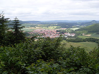
Neuhaus am Rennweg is a town in the district of Sonneberg, in Thuringia, Germany. It is situated in the Thuringian Forest, 17 km north of Sonneberg, and 22 km southwest of Saalfeld. The former municipalities Lichte and Piesau were merged into Neuhaus am Rennweg in January 2019.

<span class="mw-page-title-main">Spessart, Rhineland-Palatinate</span> Municipality in Rhineland-Palatinate, Germany

Spessart is a municipality in the district of Ahrweiler, in Rhineland-Palatinate, Germany.

Merkers-Kieselbach is a former municipality in the Wartburgkreis district of Thuringia, Germany. Since 31 December 2013, it is part of the municipality Krayenberggemeinde.

<span class="mw-page-title-main">Tottleben</span> Municipality in Thuringia, Germany

Tottleben is a municipality in the Unstrut-Hainich-Kreis district of Thuringia, Germany.

<span class="mw-page-title-main">Hirschfeld, Thuringia</span> Municipality in Thuringia, Germany

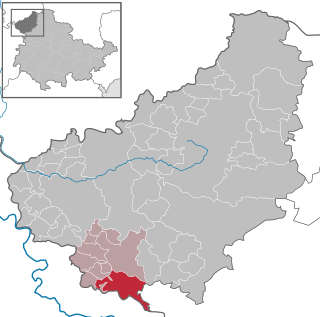
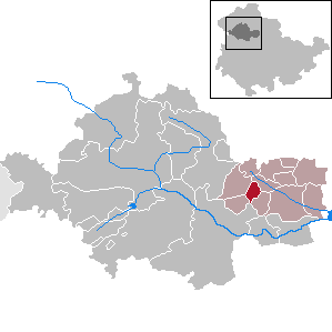
Hirschfeld is a municipality in the district of Greiz, in Thuringia, Germany. The town is member of the municipal association Am Brahmetal.

<span class="mw-page-title-main">Elxleben, Ilm-Kreis</span> Municipality in Thuringia, Germany

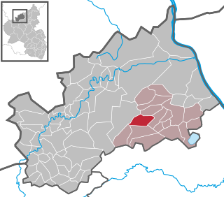
Elxleben is a municipality in the district Ilm-Kreis, in Thuringia, Germany.

<span class="mw-page-title-main">Bethenhausen</span> Municipality in Thuringia, Germany

Bethenhausen is a municipality in the district of Greiz, in Thuringia, Germany. The town is member of the municipal association Am Brahmetal.

<span class="mw-page-title-main">Großenstein</span> Municipality in Thuringia, Germany

Großenstein is a municipality in the district of Greiz, in Thuringia, Germany. The town is member of the municipal association Am Brahmetal.

<span class="mw-page-title-main">Pölzig</span> Municipality in Thuringia, Germany

Pölzig is a municipality in the district of Greiz, in Thuringia, Germany. It is member of the municipal association Am Brahmetal.

<span class="mw-page-title-main">Reichstädt</span> Municipality in Thuringia, Germany

Reichstädt is a municipality in the district of Greiz, in Thuringia, Germany. The town is member of the municipal association Am Brahmetal.

<span class="mw-page-title-main">Schwaara</span> Municipality in Thuringia, Germany

Schwaara is a municipality in the district of Greiz, in Thuringia, Germany. The town is member of the municipal association Am Brahmetal.

<span class="mw-page-title-main">Alkersleben</span> Municipality in Thuringia, Germany

Alkersleben is a municipality in the Ilm-Kreis district in Thuringia, Germany. The municipality is a member of the collective municipality Riechheimer Berg.

<span class="mw-page-title-main">Crossen an der Elster</span> Municipality in Thuringia, Germany

Crossen an der Elster is a municipality in the district Saale-Holzland, in Thuringia, Germany.

<span class="mw-page-title-main">Lausnitz</span> Municipality in Thuringia, Germany

Lausnitz is a municipality in the district Saale-Orla-Kreis, in Thuringia, Germany. It lies 4 km west of Neustadt an der Orla.

<span class="mw-page-title-main">Am Ohmberg</span> Municipality in Thuringia, Germany

Am Ohmberg is a municipality in the district of Eichsfeld, in Thuringia, Germany. It was formed by the merger of the previously independent municipalities Bischofferode, Großbodungen and Neustadt, on 1 December 2010.

<span class="mw-page-title-main">Sonnenstein, Thuringia</span> Municipality in Thuringia, Germany

Sonnenstein is a municipality in the district of Eichsfeld, Thuringia, Germany. It was formed by the merger of the previously independent municipalities Bockelnhagen, Holungen, Jützenbach, Silkerode, Steinrode, Stöckey, Weißenborn-Lüderode and Zwinge, on 1 December 2011. These municipalities had previously been part of the Verwaltungsgemeinschaft Eichsfeld-Südharz, which was disbanded. The seat of the municipality is in the village Weißenborn-Lüderode. The municipality consists of 8 Ortschaften : Bockelnhagen, Holungen, Jützenbach, Silkerode, Steinrode, Stöckey, Weißenborn-Lüderode and Zwinge.

References

  1. Gewählte Bürgermeister - aktuelle Landesübersicht, Freistaat Thüringen, accessed 10 November 2022.
  2. "Bevölkerung der Gemeinden, erfüllenden Gemeinden und Verwaltungsgemeinschaften in Thüringen Gebietsstand: 31.12.2020". Thüringer Landesamt für Statistik (in German). June 2021.
  3. "Verwaltungsgemeinschaft Ershausen/Geismar - Dieterode".
  4. Der Landeswahlleiter. "Kommunalwahlen in Thüringen am 7. Juni 2009. Wahlen der Gemeinde- und Stadtratsmitglieder. Vorläufige Ergebnisse" (PDF; 1,9 MB). Retrieved 10 March 2010.
  5. "Kommunalwahlen in Thüringen am 6. Juni 2010. Wahlen der Gemeinde- und Stadtratsmitglieder. Vorläufige Ergebnisse" (in German). Der Landeswahlleiter.
  6. Gemeinde: Dieterode, Thüringer Landesamt für Statistik