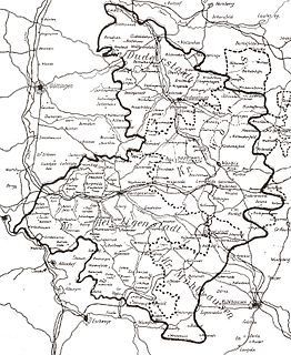
Eichsfeld is a district in Thuringia, Germany, and part of the historical region of Eichsfeld. It is bounded by the districts of Nordhausen, Kyffhäuserkreis and Unstrut-Hainich-Kreis, and by the states of Hesse and Lower Saxony.
Gernrode is a municipality in the district of Eichsfeld in Thuringia, Germany. Its agricultural land is some of the most productive in the district and it therefore does not have any wooded areas.
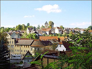
Wingerode is a municipality in the district of Eichsfeld in Thuringia, Germany. In 1996, Wingerode celebrated its 850th anniversary. It was founded in 1146.

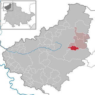
Teistungen is a municipality in the district of Eichsfeld in Thuringia, Germany.
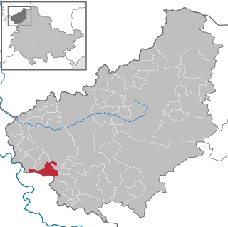
Asbach-Sickenberg is a municipality in the district of Eichsfeld, in Thuringia, Germany. As a result of the 1945 Wanfried agreement, formerly Hessian Asbach-Sickenberg became part of the Soviet occupation zone and the later German Democratic Republic.

Zeulenroda-Triebes is a German town in the district of Greiz in the state of Thuringia.

Ohrdruf is a small town in the district of Gotha in the German state of Thuringia. It lies some 30 km southwest of Erfurt at the foot of the northern slope of the Thuringian Forest. The former municipalities Crawinkel, Gräfenhain and Wölfis were merged into Ohrdruf in January 2019.

Apolda is a town in central Thuringia, Germany, the capital of the Weimarer Land district. It is situated in the center of the triangle Weimar–Jena–Naumburg near the river Ilm, c. 15 kilometres east by north from Weimar. Apolda station lies on the Halle–Bebra railway, which is part of the main line from Berlin to Frankfurt.
Stadtroda is a town of 6,653 people (2017), located in Thuringia, Germany. Stadtroda lies on the river Roda, a tributary of the Saale. The former municipalities Bollberg and Quirla were merged into Stadtroda in January 2019.

Schmalkalden is a town in the Schmalkalden-Meiningen district, in the southwest of the state of Thuringia, Germany. It is on the southern slope of the Thuringian Forest at the Schmalkalde river, a tributary to the Werra. As of 31 December 2010, the town had a population of 19,978.

Artern is a town in the Kyffhäuserkreis district, Thuringia, Germany. The former municipalities Heygendorf and Voigtstedt were merged into Artern in January 2019.

Schleiz is a town in the district of Saale-Orla-Kreis in Thuringia, Germany. The former municipality Crispendorf was merged into Schleiz in January 2019, and Burgk in December 2019.
Zella-Mehlis is a town in the Schmalkalden-Meiningen district, in Thuringia, Germany. It is situated in the Thuringian Forest, 5 km north of Suhl, and 20 km east of Meiningen. The town of Zella-Mehlis is the site of the original Walther Arms and J.G. Anschütz weapons factories. They remained there until the Soviets occupied eastern Germany at the end of World War II. The former municipality Benshausen was merged into Zella-Mehlis in January 2019.

Blankenhain is a town in the Weimarer Land district, in Thuringia, Germany. It is 14 km south of Weimar.

Buttstädt is a municipality in the district of Sömmerda, in Thuringia, Germany. It is situated 16 km northeast of Weimar. The former municipalities Ellersleben, Eßleben-Teutleben, Großbrembach, Guthmannshausen, Hardisleben, Kleinbrembach, Mannstedt, Olbersleben and Rudersdorf were merged into Buttstädt in January 2019.

Gerstungen is a municipality in the Wartburgkreis district of Thuringia, Germany. In July 2018 the former municipalities of Marksuhl and Wolfsburg-Unkeroda were merged into Gerstungen.

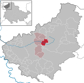
Körner is a municipality in the Unstrut-Hainich-Kreis district of Thuringia, Germany.

Gerstenberg is a municipality in the district of Altenburger Land, in Thuringia, Germany. Gerstenberg was first mentioned in a document in 1227. The line of knights "von Gerstenberg" died out in 1710. As early as 1181, a fortification was mentioned in the district of Pöschwitz. This later manor passed into civil ownership in 1798. Members of the families served the dukes of Saxe-Gotha and Saxe-Altenburg. After the expropriation in 1951, what was once the largest farm was just a residential property with MTS and a small new farmer.

Rositz is a municipality in the district Altenburger Land, in Thuringia, Germany.

Probstzella is a municipality in the district Saalfeld-Rudolstadt, in Thuringia, Germany.


