Eichsfeld is a district in Thuringia, Germany, and part of the historical region of Eichsfeld. It is bounded by the districts of Nordhausen, Kyffhäuserkreis and Unstrut-Hainich-Kreis, and by the states of Hesse and Lower Saxony.
The Kyffhäuserkreis is a district in the northern part of Thuringia, Germany. Neighboring districts are the districts Mansfeld-Südharz, Saalekreis und Burgenlandkreis in Saxony-Anhalt, and the districts Sömmerda, Unstrut-Hainich-Kreis and Eichsfeld.
Nordhausen is a Kreis (district) in the north of Thuringia, Germany. Neighboring districts are : Harz and Mansfeld-Südharz in Saxony-Anhalt; Kyffhäuserkreis and Eichsfeld in Thuringia; and Göttingen and Goslar in Lower Saxony.
Unstrut-Hainich-Kreis is a Kreis (district) in the north of Thuringia, Germany. Neighboring districts are the districts Eichsfeld, Kyffhäuserkreis, Sömmerda, Gotha, Wartburgkreis and the district Werra-Meißner in Hesse.

Dingelstädt is a town in the district of Eichsfeld in Thuringia, Germany. It is situated on the upper course of the river Unstrut, 8 km (5 mi) south of Leinefelde-Worbis and 15 km (9 mi) northwest of Mühlhausen. The former municipalities Helmsdorf, Kefferhausen, Kreuzebra and Silberhausen were merged into Dingelstädt in January 2019.

Niederorschel is a municipality in the district of Eichsfeld in Thuringia, Germany. The former municipalities Deuna, Gerterode, Hausen and Kleinbartloff were merged into Niederorschel in January 2019. It further includes the localities of Niederorschel, Oberorschel, and Rüdigershagen.
Gernrode is a municipality in the district of Eichsfeld in Thuringia, Germany. Its agricultural land is some of the most productive in the district and it therefore does not have any wooded areas.

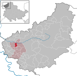
Volkerode is a municipality in the district of Eichsfeld in Thuringia, Germany.
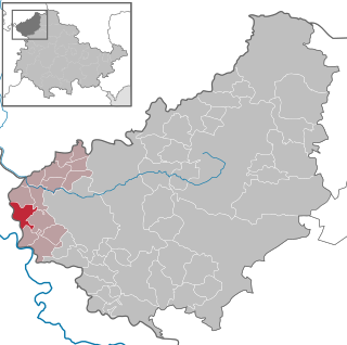
Bornhagen is a municipality in the district of Eichsfeld in Thuringia, Germany, located at the foot of the ruins of Hanstein Castle. The town district Rimbach is positioned directly south of the castle citadel at an elevation of 370 m. Bornhagen is located 22 km south of Göttingen, 85 km northwest of the state capital Erfurt and 270 km southwest of Berlin. It is the westernmost settlement in Thuringia but does not contain the westernmost point which is 75 km south near Geisa.

Lindewerra is a municipality in the district of Eichsfeld in Thuringia, Germany. It is part of the Verwaltungsgemeinschaft Hanstein-Rusteberg. Before the fall of the Berlin Wall in 1989 Lindewerra was one of the few villages in the German Democratic Republic that could be observed directly from the West. After the fall of the Berlin Wall a bridge was built to connect the village to the Hessian bank of the Werra River.

Heuthen is a municipality in the district of Eichsfeld in Thuringia, Germany. It is the seat of a fourth-order administrative division. In 2017 it had a population of 764.
Wingerode is a municipality in the district of Eichsfeld in Thuringia, Germany. In 1996, Wingerode celebrated its 850th anniversary. It was founded in 1146.

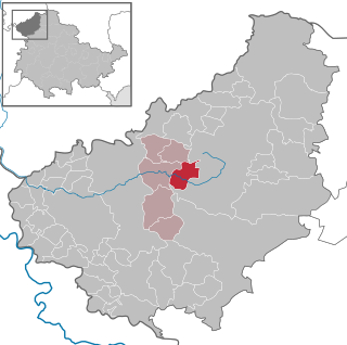
Teistungen is a municipality in the district of Eichsfeld in Thuringia, Germany.

Eichstruth is a municipality in the district of Eichsfeld in Thuringia, Germany. By area, it is the smallest municipality in what was East Germany, although there are 35 rural municipalities ("Gemeinden") and one city ("Stadt"), Arnis, in what was West Germany that have lesser or equal area.
Thalwenden is a municipality in the district of Eichsfeld in Thuringia, Germany.

Lederhose is a municipality in the Greiz district of Thuringia, Germany. The town has a municipal association with Münchenbernsdorf. The name is a well-known example of an unusual place name as it is synonymous with the German term for Lederhosen, hence the coat of arms. The name of the village derives probably from the slavic name Ludorad and has no historical link to the piece of clothes. The national A9 expressway has an interchange named after the rather small village which makes the name appearing regularly in traffic reporting via radio.

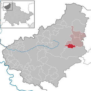
Sonnenstein is a municipality in the district of Eichsfeld, Thuringia, Germany. It was formed by the merger of the previously independent municipalities Bockelnhagen, Holungen, Jützenbach, Silkerode, Steinrode, Stöckey, Weißenborn-Lüderode and Zwinge, on 1 December 2011. These municipalities had previously been part of the Verwaltungsgemeinschaft Eichsfeld-Südharz, which was disbanded. The seat of the municipality is in the village Weißenborn-Lüderode. The municipality consists of 8 Ortschaften : Bockelnhagen, Holungen, Jützenbach, Silkerode, Steinrode, Stöckey, Weißenborn-Lüderode and Zwinge.
Eichsfeld I is an electoral constituency represented in the Landtag of Thuringia. It elects one member via first-past-the-post voting. Under the current constituency numbering system, it is designated as constituency 1. It comprises the western part of the district of Eichsfeld, including its capital Heilbad Heiligenstadt.
Eichsfeld II is an electoral constituency represented in the Landtag of Thuringia. It elects one member via first-past-the-post voting. Under the current constituency numbering system, it is designated as constituency 2. It comprises the eastern part of the district of Eichsfeld.
Kyffhäuserkreis I – Eichsfeld III is an electoral constituency represented in the Landtag of Thuringia. It elects one member via first-past-the-post voting. Under the current constituency numbering system, it is designated as constituency 10. It covers the western part of Kyffhäuserkreis and a small part of Eichsfeld district.


