Donga Department

Last updated
Donga
Extensive Landwirtschaft im Norden Benins bei Djougou.jpg
Agriculture near Djougou, the department capital
Benin - Donga.svg
Map highlighting the Donga Department
Coordinates: 9°42′N1°40′E / 9.700°N 1.667°E / 9.700; 1.667 Coordinates: 9°42′N1°40′E / 9.700°N 1.667°E / 9.700; 1.667
Country Flag of Benin.svg  Benin
Capital Djougou
Area
[1]
  Total11,126 km2 (4,296 sq mi)
Population
 (2013 census)
  Total542,605
  Density49/km2 (130/sq mi)
Time zone UTC+1 (WAT)

Donga is one of the twelve departments of Benin; its capital is Djougou, the fourth largest city in the country. The department of Donga was created in 1999 when it was split off from Atakora Department. Donga is subdivided into five communes, each centered at one of the principal towns: Bassila, Copargo, Djougou Rural, Djougou Urban and Ouaké.

Contents

As of 2013, the total population of the department was 543,130, with 270,754 males and 272,376 females. The proportion of women was 50.10%. The total rural population was 57.90%, while the urban population was 42.10%. The total labour force in the department was 120,021, of which 24.20% were women. The proportion of households with no level of education was 72.50%.

Geography

Road in Copargo, Benin Ortseingang Copargo.JPG
Road in Copargo, Benin

Donga Department, with an area of 10,691 square kilometres (4,128 sq mi), is located in north-central Benin, bordering Atakora Department to the north, Borgou Department to the east, Collines Department to the south, and Togo to the west. The northwest region of Benin consists mostly of forested mountains, from which two tributaries of the Niger River, the Mékrou River and the Pendjari River, originate. [2] Mont Sokbaro, widely cited as the highest point of Benin, lies on the border of Donga Department with Togo. The northern regions of Benin receive one season of rainfall from May to September, while the southern regions receive two spells of rain from March to July and September to November. The country receives an average annual rainfall of around 1,200 mm (47 in). [3]

Settlements

Djougou is the departmental capital; other major settlements include Aledjo-Koura, Aworo, Bassila, Bodi, Copargo, Kolokondé, Ouaké, Patargo, Pélébina, Pénéssoulou and Prekete.

Demographics

Religious census [4]
ReligionPercent(%)
Muslim
77.9%
Methodist
1%
Vodoun
0.4%
Catholic
11.9%
Celestial
0.2%
Other Christian
1.8%
Other Traditional
1.8%
Other
0.5%
Other Protestant
1.1%

According to Benin's 2013 census, the total population of the department was 543,130, with 270,754 males and 272,376 females. The proportion of women was 50.10%. The total rural population was 57.90%, while the urban population was 42.10%. The proportion of women of childbearing age (15 to 49 years old) was 23.30%. The foreign population was 7,760, representing 1.40% of the total population in the department. The labour force participation rate among foreigners aged 15–64 years was 30.70%. The proportion of women among the foreign population constituted 50.50%. The number of households in the department was 66,433 and the average household size was 8.2. The intercensal growth rate of the population was 4.00%. [5]

Among women, the average age at first marriage was 20.5 and the average age at maternity was 28. The synthetic index of fertility of women was 4.6. The average number of families in a house was 1.8 and the average number of persons per room was 1.8. The total labour force in the department was 120,021, of which 24.20% were women. The proportion of households with no level of education was 72.50% and the proportion of households with children attending school was 51.40%. The crude birth rate was 34.6, the general rate of fertility was 148.70 and the gross reproduction rate was 2.30. [4]

The main ethnolinguistic groups in the department are the Dendi and Yoruba. Other groups include the Anii, Bariba, Ede, Foodo, Kabiye, Lama, Lukpa, Tammari (also known as the Betammaribe, or Somba), Miyobe and Yom. [6]

Administrative divisions

Communes of Donga Donga communes.png
Communes of Donga

The department of Donga was created in 1999 when it was split off from Atakora Department. Its capital is Djougou. [7] Donga is subdivided into five communes, each centered at one of the principal towns: Bassila, Copargo, Djougou Rural, Djougou Urban and Ouaké. [8]

Benin originally had six administrative regions (départements), which have now been bifurcated to make 12. Each of the deconcentrated administrative services (directions départementales) of the sectoral ministries takes care of two administrative regions. A law passed in 1999 transformed the sous-prefectures, the lowest level of territorial administration, into local governments. [8] Municipalities and communal councils have elected representatives who manage the administration of the regions. The latest elections of the municipal and communal councils were held in June 2015. [9]

Related Research Articles

<span class="mw-page-title-main">Demographics of Benin</span>

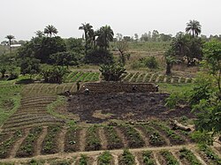
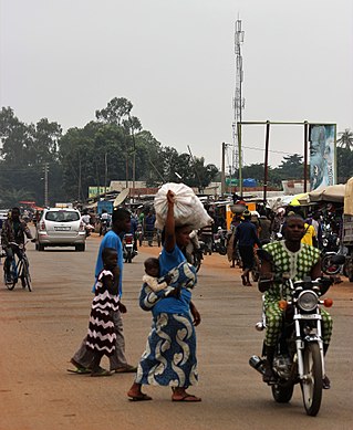
The demographics of Benin include population density, ethnicity, education level, health of the populace, economic status, religious affiliations and other aspects of the population.

<span class="mw-page-title-main">Alibori Department</span> Department of Benin

Alibori is the largest and northernmost department of Benin. Externally the department borders the countries of Burkina Faso, Niger, and Nigeria, and internally the departments of Atakora and Borgou. The department of Alibori was created in 1999 when it was split off from Borgou Department and is named after the Alibori River.

<span class="mw-page-title-main">Atakora Department</span> Department of Benin

Atakora is the northwesternmost department of Benin. Externally it borders Togo to the west and Burkina Faso to the north; internally it borders the departments of Alibori, Borgou and Donga. Major towns in the Atakora include Natitingou and Tanguiéta, and the major tourist areas include the Tata Somba houses, Pendjari National Park, and various waterfalls. The department of Atakora was bifurcated in 1999, with its southern territory removed to form the newly created Donga Department. The capital of Atakora Department is Natitingou; it is after the Atakora Mountains.

<span class="mw-page-title-main">Collines Department</span> Department of Benin

Collines is one of the twelve departments of Benin, located in the centre of the country; its name means "hills" in French. The department of Collines was created in 1999 when it was split off from Zou Department. In 2016, the city of Dassa-Zoumé became the department's capital.

<span class="mw-page-title-main">Littoral (Benin)</span> Department of Benin

Littoral is one of the twelve departments of Benin. At 79 km2 (31 sq mi), Littoral is the smallest department in the country. Its capital is Cotonou, Benin's largest city. The department was created in 1999 with the splitting up of territories of Atlantique Department.

<span class="mw-page-title-main">Ouémé Department</span> Department of Benin

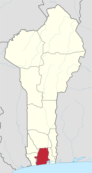
Ouémé is one of the twelve departments of Benin, containing the capital of the country Porto Novo. It is subdivided into nine communes, each centred at one of the principal towns: Adjarra, Adjohoun, Aguégués, Akpro-Missérété, Avrankou, Bonou, Dangbo, Porto-Novo and Sèmè-Kpodji. In 1999, the northern section of Ouémé was split off to form the department of Plateau.

<span class="mw-page-title-main">Zou Department</span> Department of Benin

Zou is one of the twelve departments of Benin, named for the Zou River which travels through the department before emptying into the Atlantic in the south of the country. The department of Zou was split in two in 1999, with the northern territory transferred to the newly created Collines Department. The capital of Zou is Abomey. Zou is subdivided into nine communes, each centred at one of the principal towns: Abomey, Agbangnizoun, Bohicon, Cové, Djidja, Ouinhi, Za-Kpota, Zangnanado and Zogbodomey.

<span class="mw-page-title-main">Plateau Department</span> Department of Benin

Plateau is one of the twelve departments of Benin. The department of Plateau was created in 1999 with an area of 2,835 square kilometres (1,095 sq mi) when it was split off from Ouémé Department. Plateau is subdivided into five communes, each centred at one of the principal towns: Adja-Ouèrè, Ifangni, Kétou, Pobè and Sakété.

<span class="mw-page-title-main">Mono Department</span> Department of Benin

Mono is one of the twelve departments of Benin, with its capital at Lokossa. It is named for the Mono River which forms much of the border with Togo. The northern areas of the department were split off to create the newly formed Kouffo Department in 1999. Mono is subdivided into six communes, each centred at one of the principal towns, namely, Athiémè, Bopa, Comè, Grand-Popo, Houéyogbé and Lokossa. It has an area of 1,396 square kilometres (539 sq mi).

<span class="mw-page-title-main">Atlantique Department</span> Regional department in the country of Benin

Atlantique is one of the twelve departments in Benin. The department is located in south-central Benin along the Atlantic coast, between Mono and Kouffo Department in the west, Zou in the north, and Ouémé in the east. The department of Atlantique was bifurcated in 1999 when some of its territories was transferred to the newly formed Littoral Department.

<span class="mw-page-title-main">Kouffo Department</span> Department of Benin

Kouffo or Couffo is one of the twelve departments of Benin. Kouffo borders the country of Togo and the departments of Mono, Zou and Atlantique. Since 2008, the department's capital has been Aplahoué. The department of Kouffo was created in 1999 when it was split off from Mono Department.

<span class="mw-page-title-main">Borgou Department</span> Department of Benin

Borgou is one of the twelve departments of Benin. Borgou borders the country of Nigeria and the departments of Alibori, Atakora, Collines and Donga. The capital of Borgou is Parakou. The department of Borgou was bifurcated in 1999, with its northern territory transferred to the newly created Alibori Department.

<span class="mw-page-title-main">Bassila</span> Commune in Donga Department, Benin

Bassila is a town, arrondissement, and commune located in the Donga Department of Benin. The commune covers an area of 120 square kilometres and as of 2013 had a population of 130,770 people.

<span class="mw-page-title-main">Communes of Benin</span> Second-level administrative divisions of Benin

The departments of Benin are subdivided into 77 communes, which in turn are divided into arrondissements and finally into villages or city districts. Prior to 1999 provinces were broken down into 84 districts, titled either urban or rural. Before independence, the six provinces were subdivided into Cercles, cantons, préfectures and villages or towns.

The Lambas are an ethnic and linguistic group of people living in the Kéran and Doufelgou Districts (Préfecture) of the Kara Region in Northern Togo and in the Atakora and Donga Departments of Bénin, West Africa. The capital of the Kéran District is Kanté and the capital of the Doufelgou District is Niamtougou.

<span class="mw-page-title-main">Religion in Benin</span> Religion in the country

Religion in Benin is characterized by diversity and pluralism, with no particular religion constituting an absolute majority of the population. Christianity is the most widely professed religion, and substantial populations of Muslims and adherents of Traditional Faiths are also present in the country. According to the most recent 2013 census, the population of Benin is 27.7% Muslim, 25.5% Roman Catholic, 13.5% Protestant, 11.6% Vodun, 9.5% of other Christian denominations, and 12.2% of others or none.

Biguina is a community or village in the commune of Bassila in the Donga Department of northwestern Benin. It is located near the border with Togo and it sits on Benin's Route Nationale 3, one of the two main north-south highways in the country.

Mont Sokbaro is a hill that is mostly cited as the highest point of Benin, with an elevation of 658 metres (2,159 ft). This designation is contested, as SRTM readings at coordinates 10°17′22″N1°32′38″E give an elevation of 672 metres (2,205 ft). This is a location 2.5 kilometres (1.6 mi) southeast of Kotoponga.

Djougou I is an arrondissement in the Donga department of Benin. It is an administrative division under the jurisdiction of the commune of Djougou. According to the population census conducted by the Institut National de la Statistique Benin on February 15, 2002, the arrondissement had a total population of 27,334.

Djougou III is an arrondissement in the Donga department of Benin. It is an administrative division under the jurisdiction of the commune of Djougou. According to the population census conducted by the Institut National de la Statistique Benin on February 15, 2002, the arrondissement had a total population of 17,713.

References

  1. "Benin". Geohive. Archived from the original on 2017-02-01. Retrieved 25 November 2016.
  2. McColl, R. W. (2014). Encyclopedia of World Geography, Volume 1. Infobase Publishing. pp. 92–93. ISBN   9780816072293.
  3. Haggett, Peter, ed. (2002). Encyclopedia of World Geography, Volume 17. Marshall Cavendish. p. 2325. ISBN   9780761473060.
  4. 1 2 "Socio economic data of Benin, 2013". Institut National de la Statistique et de l’Analyse Economique (INSAE) du Benin. 2013. Retrieved 25 November 2016.
  5. "Census of Benin, 2013". Institut National de la Statistique et de l’Analyse Economique (INSAE) du Benin. 2013. Retrieved 25 November 2016.
  6. "Languages of Benin". Ethnologue . Retrieved 26 November 2019.
  7. Houngnikpo, Mathurin C.; Decalo, Samuel (2013). Historical Dictionary of Benin. Rowman & Littlefield. pp. 143–4. ISBN   9780810871717.
  8. 1 2 Republic of Benin, Public Administration and Country profile (PDF) (Report). Department of Economic and Social Affairs (DESA), United Nations. 2004. p. 8. Retrieved 17 November 2016.
  9. "Local elections in Benin, 2015". African Elections Database. Retrieved 25 November 2016.