 |
|---|
| |

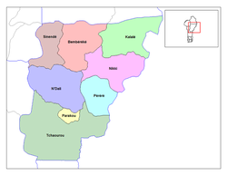
The departments of Benin are subdivided into 77 communes, which in turn are divided into arrondissements and finally into villages or city districts. Prior to 1999 provinces were broken down into 84 districts, titled either urban or rural. Before independence, the six provinces were subdivided into cercles, cantons, préfectures and villages or towns.
Contents
- Alibori
- Atakora
- Atlantique
- Borgou
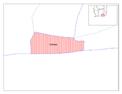
- Collines
- Donga
- Kouffo
- Littoral
- Mono
- Ouémé
- Plateau
- Zou
- References
- Sources
The communes are listed below, by department: