Atlantique is one of the twelve departments in Benin. The department is located in south-central Benin along the Atlantic coast, between Mono and Kouffo Department in the west, Zou in the north, and Ouémé in the east. The department of Atlantique was bifurcated in 1999 when some of its territories was transferred to the newly formed Littoral Department.
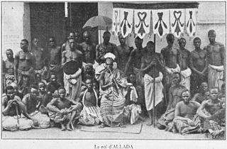
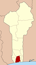
Allada is a town, arrondissement, and commune, located in the Atlantique Department of Benin.

Athiémè is a town and arrondissement located in the Mono Department of Benin. The commune covers an area of 220 square kilometres and as of 2013 had a population of 56,483 people.
The departments of Benin are subdivided into 77 communes, which in turn are divided into arrondissements and finally into villages or city districts. Prior to 1999 provinces were broken down into 84 districts, titled either urban or rural. Before independence, the six provinces were subdivided into Cercles, cantons, préfectures and villages or towns.
N'Dali is a city and arrondissement in the north of Benin, and the capital of the Commune of N'Dali in the Borgou Department. The commune covers an area of 3748 square kilometres and as of 2013 had a population of 113,604 people. In 2008 there were an estimated 16,941 people living in the main town of N'Dali.
Sô-Ava is a town, arrondissement, and commune in the Atlantique Department of southern Benin. The commune covers an area of 218 square kilometres and as of 2002 had a population of 76,315 people.
Toffo is a town and commune in the Atlantique Department of southern Benin. The commune covers an area of 515 square kilometres and as of 2002 had a population of 74,717 people.
Zè is a town, arrondissement, and commune in the Atlantique Department of southern Benin. The commune covers an area of 543 square kilometres and as of 2013 had a population of 106,913 people.
Avrankou is a town, arrondissement, and commune in the Ouémé Department of south-eastern Benin. The commune covers an area of 150 square kilometres and as of 2013 had a population of 128,050 people.
Bonou is a town, arrondissement, and commune in the Ouémé Department of south-eastern Benin. The commune covers an area of 275 square kilometres and as of 2002 had a population of 29,656 people.
Dangbo is a town, arrondissement, and commune in the Ouémé Department of south-eastern Benin.The commune covers an area of 340 square kilometres and as of 2002 had a population of 66,055 people. Dangbo is the site of Benin's Institute for Mathematics and Physical Sciences.

Sèmè-Kpodji is a town, arrondissement, and commune in the Ouémé Department of south-eastern Benin. The commune covers an area of 250 square kilometres and as of 2013 had a population of 222,701 people.
Zogbodomey or Zogbodomè is a town, arrondissement, and commune in the Zou Department of south-western Benin. The commune covers an area of 600 square kilometres and as of 2002 had a population of 72,338 people.
Arrondissements are administrative units of Benin, after departments and communes. In turn they contain villages and may often have several quartiers or city districts/urban neighborhoods. There are currently 545 arrondissements.
Bouhadjar is a town and commune in El Taref Province, Algeria. According to the 1998 census it has a population of 16,385.
Avamè is a town and arrondissement in the Atlantique Department of southern Benin. It is an administrative division under the jurisdiction of the commune of Tori-Bossito. According to the population census conducted by the Institut National de la Statistique Benin on February 15, 2002, the arrondissement had a total population of 4,444.
Azohouè-Aliho is a town and arrondissement in the Atlantique Department of southern Benin. It is an administrative division under the jurisdiction of the commune of Tori-Bossito. According to the population census conducted by the Institut National de la Statistique Benin on February 15, 2002, the arrondissement had a total population of 2,258.
Azohouè-Cada is a town and arrondissement in the Atlantique Department of southern Benin. It is an administrative division under the jurisdiction of the commune of Tori-Bossito. According to the population census conducted by the Institut National de la Statistique Benin on February 15, 2002, the arrondissement had a total population of 6,457.
Tori-Cada is a town and arrondissement in the Atlantique Department of southern Benin. It is an administrative division under the jurisdiction of the commune of Tori-Bossito. According to the population census conducted by the Institut National de la Statistique Benin on February 15, 2002, the arrondissement had a total population of 11,952.
Tori-Gare is a town and arrondissement in the Atlantique Department of southern Benin. It is an administrative division under the jurisdiction of the commune of Tori-Bossito. According to the population census conducted by the Institut National de la Statistique Benin on February 15, 2002, the arrondissement had a total population of 6,997.