Porto-Novo is the capital and second-largest city of Benin. The commune covers an area of 110 square kilometres (42 sq mi) and as of 2002 had a population of 223,552 people.

Abomey is the capital of the Zou Department of Benin. The commune of Abomey covers an area of 142 square kilometres and, as of 2012, had a population of 90,195 people.
Malanville is a city, arrondissement and commune in the Alibori Department of northeastern Benin, located across the River Niger from Niger. It is known as a centre of cross-border trade and has a major market. Malanville is also a centre for rice-growing. The commune covers an area of 3016 square kilometres and as of 2013 had a population of 168,006 people.

Natitingou, informally referred to as Nati, is a city and commune in north western Benin and the capital of Atakora Department. The commune covers an area of 3045 square kilometres and as of 2013 had a population of 104,010 people.
Boukoumbé or Boukombé is a town, arrondissement and commune in north western Benin on the border with Togo. It is known for its market, its whipping ceremony and for its tradition of pipe making. Mount Kousso-Kovangou, the highest point in Benin, lies nearby.

Bassila is a town, arrondissement, and commune located in the Donga Department of Benin. The commune covers an area of 120 square kilometres and as of 2013 had a population of 130,770 people.
Cové is a city in the Zou Department of Benin. The commune covers an area of 525 square kilometres and as of 2012 had a population of 43,554 people.
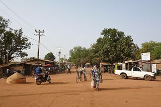
Kouandé is a town, arrondissement and commune, located in the Atakora Department of Benin.The commune covers an area of 4500 square kilometres and as of 2013 had a population of 112,014 people. The main town had an estimated 7,127 people in 2008.
Ségbana is a town, arrondissement and commune located in the Alibori Department of Benin. The commune covers an area of 4471 square kilometres and as of 2013 had a population of 89,268 people.
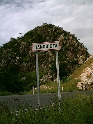
Tanguiéta is a town, arrondissement and commune located in the Atakora Department of Benin.The commune covers an area of 5465 square kilometres and as of 2013 had a population of 74,675 people. As of 2007 the town had an estimated population of 21,290. It lies on the RNIE 3 highway which connects it to Natitingou.
Karimama is a town, arrondissement and commune in the Alibori Department of northeastern Benin. The commune covers an area of 6102 square kilometers and as of 2013 had a population of 66,675 people. The town lies on the border with Niger.
Gogounou is a town, arrondissement and commune in the Alibori Department of Benin, about 35 kilometres south of Kandi. The commune covers an area of 4910 square kilometres and as of 2013 had a population of 117,793 people.
Adjohoun or Adjohon is a town, arrondissement, and commune in Ouémé Department, Benin. The commune is divided into 8 arrondissements and 57 villages. The commune of Adjohoun is located approximately 32 km from Porto-Novo and 62 km from Cotonou. The commune covers an area of 308 km2 and as of 2002 had a population of 60,955, 48.14% male and 51.86% female. The commune covers an area of 112 square kilometres and as of 2002 had a population of 60,112 people.
Cobly or Kobli is a town, arrondissement and commune in the Atakora Department of north-western Benin.
Glazoué is a town, arrondissement, and commune in the Collines Department of central Benin. It is located on the railway line from Cotonou to Parakou. The commune covers an area of 1350 square kilometres and as of 2013 had a population of 124,431 people.
Agbangnizoun is a town, arrondissement, and commune in the Zou Department of south-western Benin. The town lies 20 kilometres south-east of Abomey. The commune covers an area of 244 square kilometres and as of 2002 had a population of 55,001 people.
Djidja is a town, arrondissement, and commune in the Zou Department of south-western Benin. The commune covers an area of 2184 square kilometres and as of 2013 had a population of 123,542 people.
Ouinhi is a town, arrondissement, and commune in the Zou Department of south-western Benin. The commune covers an area of 483 square kilometres and as of 2013 had a population of 59,381 people. It is bounded on the north-west by the commune of Zagnanado, south-west by the commune of Zogbodomey, south by the commune of Bonou and east by the commune of Adja-Ouèrè. The commune is divided into arrondissements which include Dasso, Ouinhi, and Tohu, comprising 28 villages.
Zogbodomey or Zogbodomè is a town, arrondissement, and commune in the Zou Department of south-western Benin. The commune covers an area of 600 square kilometres and as of 2002 had a population of 72,338 people.

Kandi is a town, arrondissement and commune in the Alibori Department of eastern Benin. Originally a market town, Kandi is now primarily a farming centre. It lies on the nation's main north-south highway, 650 km (400 mi) from Cotonou and 523 km (325 mi) north of Porto-Novo. The town is the capital of the department of Alibori. The commune covers an area of 3,421 km2 (1,321 sq mi) and as of 2013 had a population of 177,683 people. The town itself had a population of 27,227 in 2002.