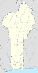
Benin, officially the Republic of Benin, and formerly Dahomey, is a country in West Africa. It is bordered by Togo to the west, Nigeria to the east, Burkina Faso to the north-west, and Niger to the north-east. The majority of its population lives on the southern coastline of the Bight of Benin, part of the Gulf of Guinea in the northernmost tropical portion of the Atlantic Ocean. The capital is Porto-Novo, and the seat of government is in Cotonou, the most populous city and economic capital. Benin covers an area of 114,763 square kilometres (44,310 sq mi) and its population in 2021 was estimated to be approximately 13 million. It is a small, tropical country. It is one of the least developed, with an economy heavily dependent on agriculture, and is an exporter of palm oil and cotton. Some employment and income arise from subsistence farming.
Porto-Novo is the capital and second-largest city of Benin. The commune covers an area of 110 square kilometres (42 sq mi) and as of 2002 had a population of 223,552 people.

Abomey is the capital of the Zou Department of Benin. The commune of Abomey covers an area of 142 square kilometres and, as of 2012, had a population of 90,195 people.

The Fon people, also called Fon nu, Agadja or Dahomey, are a Gbe ethnic group. They are the largest ethnic group in Benin found particularly in its south region; they are also found in southwest Nigeria and Togo. Their total population is estimated to be about 3,500,000 people, and they speak the Fon language, a member of the Gbe languages.
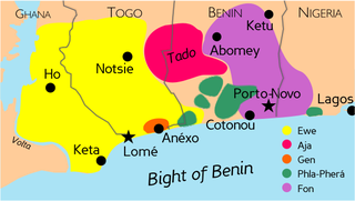
The Gbe languages form a cluster of about twenty related languages stretching across the area between eastern Ghana and western Nigeria. The total number of speakers of Gbe languages is between four and eight million. The most widely spoken Gbe language is Ewe, followed by Fon. The Gbe languages were traditionally placed in the Kwa branch of the Niger–Congo languages, but more recently have been classified as Volta–Niger languages. They include five major dialect clusters: Ewe, Fon, Aja, Gen (Mina), Gun and Phla–Pherá.

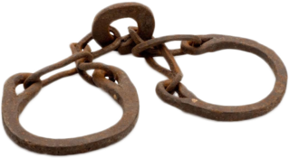
The Slave Coast is a historical name formerly used for that part of coastal West Africa along the Bight of Biafra and the Bight of Benin that is located between the Volta River and the Lagos Lagoon. The name is derived from the region's history as a major source of African people sold into slavery during the Atlantic slave trade from the early 16th century to the late 19th century.

Ouidah or Whydah, and known locally as Glexwe, formerly the chief port of the Kingdom of Whydah, is a city on the coast of the Republic of Benin. The commune covers an area of 364 km2 (141 sq mi) and as of 2002 had a population of 76,555 people.

Parakou is the largest city in northern Benin, and the third-largest city in the country, with an estimated population of around 206,667 people, and capital of the Borgou Department. Administratively the commune of Parakou makes up one of Benin's 77 communes. Since 2015, its mayor is Souradjou Adamou Karimou.

Natitingou, informally referred to as Nati, is a city and commune in north western Benin and the capital of Atakora Department. The commune covers an area of 3045 square kilometres and as of 2013 had a population of 104,010 people.

Aného, previously known as Anecho, is a town in southeastern Togo, lying on the Gulf of Guinea near the border of Benin. Founded in the late 17th century by Ane people fleeing from Denkyira attacks in Elmina, Aného developed as a slave port and commercial center. It was the capital of German Togoland from 1885 to 1887 and of the French occupation from 1914 to 1920. Aného remains an important intellectual center for Togo, though it has not grown as rapidly as Togo’s other major cities. Its estimated population in 2005 was 25,400.
The Phla–Pherá (Xwla–Xwela) languages form a possible group of Gbe languages spoken mainly in southeastern and southwestern Benin; some communities are found in southeastern Togo and southwestern Nigeria. The group, comprising about ten varieties, was introduced by H.B. Capo in his 1988 classification of Gbe languages as one of the five main branches of Gbe. Additional research carried out by SIL International in the nineties corroborated many of Capo's findings and led to adjustment of some of his more tentative groupings; in particular, Phla–Pherá was divided in an eastern and a western cluster. Phla–Pherá is one of the smaller Gbe branches in terms of number of speakers. It is also the most linguistically diverse branch of Gbe, due partly to the existence of several geographically separated communities, but mainly because of considerable influence by several non-Gbe languages in the past. Some of the Phla–Pherá peoples are thought to be the original inhabitants of the region having intermingled with Gbe immigrants.

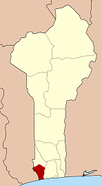
Mono is one of the twelve departments of Benin, with its capital at Lokossa. It is named for the Mono River which forms much of the border with Togo. The northern areas of the department were split off to create the newly formed Kouffo Department in 1999. Mono is subdivided into six communes, each centred at one of the principal towns, namely, Athiémè, Bopa, Comè, Grand-Popo, Houéyogbé and Lokossa. It has an area of 1,396 square kilometres (539 sq mi).

Aflao is a town in Ketu South District in the Volta Region on Ghana's border with Togo. Aflao is the twenty-eighth most populous settlement in Ghana, in terms of population, with a population of 96,550 people.
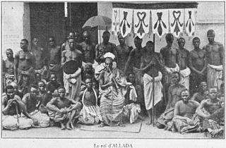
Allada is a town, arrondissement, and commune, located in the Atlantique Department of Benin.

Manillas are a form of commodity money, usually made of bronze or copper, which were used in West Africa. They were produced in large numbers in a wide range of designs, sizes, and weights. Originating before the colonial period, perhaps as the result of trade with the Portuguese Empire, manillas continued to serve as money and decorative objects until the late 1940s and are still sometimes used as decoration on arms, legs and around the neck. In popular culture, they are particularly associated with the Atlantic slave trade.
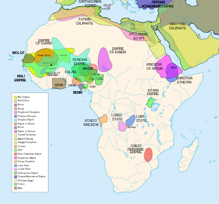
African empires is an umbrella term used in African studies to refer to a number of pre-colonial African kingdoms in Africa with multinational structures incorporating various populations and polities into a single entity, usually through conquest.
The following outline is provided as an overview of and topical guide to Benin:
The Dutch Slave Coast refers to the trading posts of the Dutch West India Company on the Slave Coast, which lie in contemporary Ghana, Benin, Togo, and Nigeria. The primary purpose of the trading post was to supply slaves for the Dutch colonies in the Americas. Dutch involvement on the Slave Coast started with the establishment of a trading post in Offra in 1660. Later, trade shifted to Ouidah, where the English and French also had a trading post. Political unrest caused the Dutch to abandon their trading post at Ouidah in 1725, now moving to Jaquim, at which place they built Fort Zeelandia. By 1760, the Dutch had abandoned their last trading post in the region.
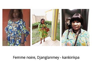
Djanglanmey is an arrondissement in the Mono department of Benin. It is an administrative division under the jurisdiction of the commune of Grand-Popo. According to the population census conducted by the Institut National de la Statistique Benin on February 15, 2002, the arrondissement had a total population of 5200. Djanglanmey is an old kingdom in west Africa and a commercial jonction in Grand-popo. This foundation was ruled by Gbokpoe Komavo. The princes and princesses are living in others countries. The traditional celebration in this town is kotafon. Before the arrival of Europeans Djanglanmey people are worshiping idols or vaudou. Now the area turn to jesus Christ by the evangelism, and the message of Christ touch so many villages in west Bénin. Djanglanmey was in the slave trade with Europeans because of the traditional priests and warriors whom are active in this trade. Their traditional language is Kotafon.