
Bohicon or Gbohikon is a city in Benin, and a conurbation of Abomey lying 9 kilometres east of the city on the railway line from Cotonou to Parakou and on Benin's main highway RNIE 2 which joins the RNIE 4. The commune covers an area of 139 square kilometres and as of 2012 had a population of 149,271 people.
Nikki is a town, arrondissement, and commune located in the Borgou Department of Benin. The commune covers an area of 3171 square kilometres and as of 2002 had a population of 99,251 people.
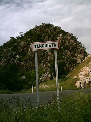
Tanguiéta is a town, arrondissement and commune located in the Atakora Department of Benin.The commune covers an area of 5465 square kilometres and as of 2013 had a population of 74,675 people. As of 2007 the town had an estimated population of 21,290. It lies on the RNIE 3 highway which connects it to Natitingou.
The departments of Benin are subdivided into 77 communes, which in turn are divided into arrondissements and finally into villages or city districts. Prior to 1999 provinces were broken down into 84 districts, titled either urban or rural. Before independence, the six provinces were subdivided into Cercles, cantons, préfectures and villages or towns.
Toucountouna is a town, arrondissement and commune in the Atakora Department of north-western Benin. The commune covers an area of 1600 square kilometres and as of 2013 had a population of 39,779 people.
Kalalè is a town, arrondissement, and commune in the Borgou Department of eastern Benin. The commune covers an area of 3,586 square kilometres (1,385 sq mi) and as of 2013 had a population of 168,882 people.
Pèrèrè is a town, arrondissement, and commune in the Borgou Department of eastern Benin. The commune covers an area of 2017 square kilometres and as of 2013 had a population of 78,988 people.
Glazoué is a town, arrondissement, and commune in the Collines Department of central Benin. It is located on the railway line from Cotonou to Parakou. The commune covers an area of 1350 square kilometres and as of 2013 had a population of 124,431 people.
Ouaké is a town, arrondissement, and commune in the Donga Department of western Benin. The commune covers an area of 663 square kilometres and as of 2013 had a population of 74,289 people.
Lalo is a town, arrondissement, and commune in the Kouffo Department of south-western Benin. The commune covers an area of 432 square kilometres and as of 2013 had a population of 119,926 people.
Toviklin is a town, arrondissement, and commune in the Kouffo Department of south-western Benin. The commune covers an area of 120 square kilometres and as of 2013 had a population of 88,611 people.
Bopa is a town, arrondissement, and commune in the Mono Department of south-western Benin.The commune covers an area of 365 square kilometres and as of 2002 had a population of 70,268 people.
Houéyogbé is a town, arrondissement, and commune in the Mono Department of south-western Benin. The commune covers an area of 290 square kilometres and as of 2002 had a population of 74,492 people.
Agbangnizoun is a town, arrondissement, and commune in the Zou Department of south-western Benin. The town lies 20 kilometres south-east of Abomey. The commune covers an area of 244 square kilometres and as of 2002 had a population of 55,001 people.
Djidja is a town, arrondissement, and commune in the Zou Department of south-western Benin. The commune covers an area of 2184 square kilometres and as of 2013 had a population of 123,542 people.
Ouinhi is a town, arrondissement, and commune in the Zou Department of south-western Benin. The commune covers an area of 483 square kilometres and as of 2013 had a population of 59,381 people. It is bounded on the north-west by the commune of Zagnanado, south-west by the commune of Zogbodomey, south by the commune of Bonou and east by the commune of Adja-Ouèrè. The commune is divided into arrondissements which include Dasso, Ouinhi, and Tohu, comprising 28 villages.
Pabégou is an arrondissement in the Donga department of Benin. It is an administrative division under the jurisdiction of the commune of Copargo. According to the population census conducted by the Institut National de la Statistique Benin on February 15, 2002, the arrondissement had a total population of 10,156.
Singré is an arrondissement in the Donga department of Benin. It is an administrative division under the jurisdiction of the commune of Copargo. According to the population census conducted by the Institut National de la Statistique Benin on February 15, 2002, the arrondissement had a total population of 13,378.
Miyobe or Soruba is an unclassified Niger-Congo language of Benin and Togo.
Djougou Rural is a municipality located in the department of Donga in the State of Benin. It includes the territory outside the city of Djougou.


