Doraville station

Last updated
Metropolitan Atlanta Rapid Transit Authority (logo).svg
NE10
Doraville
MARTA rapid transit station
Doraville Station Platform.jpg
General information
Location6000 New Peachtree Road
Doraville, GA 30340
Coordinates 33°54′07″N84°16′49″W / 33.902079°N 84.280389°W / 33.902079; -84.280389
Platforms1 island platform
Tracks2
ConnectionsAiga bus trans.svg MARTA Bus: 25, 39, 104, 124, 133
Aiga bus trans.svg Ride Gwinnett: 10A, 10B, 20, 35
Aiga bus trans.svg GRTA: 408
Construction
Structure typeElevated
Parking1,070 spaces
Bicycle facilitiesYes
AccessibleYes
Other information
Station codeNE10
History
OpenedDecember 29, 1992;31 years ago (1992-12-29)
Services
Preceding station MARTA stripes logo.svg MARTA Following station
Chamblee
toward Airport
Gold Line Terminus
Proposed Services
Preceding station BSicon LOGO Amtrak2.svg Amtrak Following station
Anniston
toward New Orleans
Crescent
proposed
Gainesville
toward New York

Doraville is a train station in Doraville, Georgia, and the northern terminus on the Gold Line of the Metropolitan Atlanta Rapid Transit Authority (MARTA) rail system. Doraville serves as the ground for the Doraville rail yard for the Gold line, with a capacity of 30 rail cars.

Contents

This station mainly serves Doraville, Tucker, Norcross, Peachtree Corners, Duluth and Lawrenceville.

This station provides access to Doraville City Hall, Doraville Health Department, Doraville Public Library, and bus service to Sugarloaf Mills (formerly Discover Mills). Bus service is also provided at this station to Oglethorpe University, Buford Highway, Phipps Plaza, Peachtree Industrial Boulevard, and Brandsmart USA.

Station layout

P
Platform level
WestboundGold Line toward Airport (Chamblee)
Island platform, doors will open on the left, right
WestboundGold Line toward Airport (Chamblee)
GStreet LevelEntrance/Exit, station house

Parking

Doraville has 1,070 daily and long term parking spaces available for MARTA users which are located in paved parking lots and one parking deck.

Bus routes

The station is served by the following MARTA bus routes:

The station is also served by the following Ride Gwinnett bus routes:

Georgia Regional Transportation Authority (GRTA) Xpress route 408 - Doraville to Johns Creek Parkway

Proposed Intercity Rail Service

Amtrak has been considering moving their service for the Atlanta area to a site near this station to replace their current station in the Brookwood neighborhood. [1] [2] While agreements with MARTA and Norfolk Southern are necessary, this would provide the station with a direct connection with Amtrak Crescent service to New York City, Charlotte, Washington, DC, Birmingham, and New Orleans.

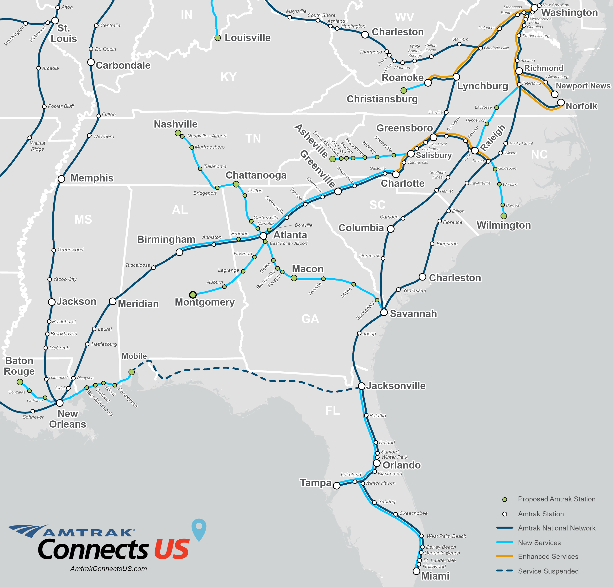
The station site is also proposed for possible intercity service on the Southeast High Speed Rail Corridor's Charlotte to Atlanta segment, should a future analysis choose an approach into Atlanta via Norfolk Southern Railway trackage. [3] If the alignment through Doraville is chosen, it is assumed at all trains along the corridor would stop here, due to its connection to the MARTA rail system. [4]

Amtrak had again listed Doraville as a proposed station stop along a corridor route from Charlotte, North Carolina to Atlanta as part of their "Connects US" plan in May 2021. [5] As part of this vision, three round trips would operate to Charlotte daily, with two of these trips extending to Union Station in Raleigh, North Carolina as a possible extension of the existing Piedmont service. [6]

Related Research Articles

<span class="mw-page-title-main">Chamblee, Georgia</span> City in Georgia, United States

Chamblee is a city in northern DeKalb County, Georgia, United States, northeast of Atlanta. The population was 30,164 as of the 2020 census.

<span class="mw-page-title-main">Metropolitan Atlanta Rapid Transit Authority</span> Public transit operator in Metro Atlanta, Georgia

The Metropolitan Atlanta Rapid Transit Authority is the principal public transport operator in the Atlanta metropolitan area. Formed in 1971 as strictly a bus system, MARTA operates a network of bus routes linked to a rapid transit system consisting of 48 miles (77 km) of rail track with 38 subway stations. MARTA's rapid transit system is the eighth-largest rapid transit system in the United States by ridership.

<span class="mw-page-title-main">Ride Gwinnett</span> Public transit system in Georgia, U.S.

Ride Gwinnett is the bus public transit system in Gwinnett County, Georgia, United States, one of metro Atlanta's three most populous suburban counties.

<span class="mw-page-title-main">Peachtree Street</span> Main street of Atlanta, Georgia, USA

Peachtree Street is one of several major streets running through the city of Atlanta, Georgia, United States. Beginning at Five Points in downtown Atlanta, it runs North through Midtown; a few blocks after entering into Buckhead, the name changes to Peachtree Road at Deering Road. Much of the city's historic and noteworthy architecture is located along the street, and it is often used for annual parades,, as well as one-time parades celebrating events such as the 100th anniversary of Coca-Cola in 1986 and the Atlanta Braves' 1995 and 2021 World Series victories.

<span class="mw-page-title-main">Georgia State Route 141</span> Highway in Georgia

State Route 141 (SR 141) is a 34.1-mile-long (54.9 km) state highway that runs southwest-to-northeast in the northwest part of the U.S. state of Georgia. It connects the Buckhead area of Atlanta with Cumming. Its routing exists within portions of Fulton, DeKalb, Gwinnett, Forsyth counties.

<span class="mw-page-title-main">Georgia State Route 13</span> State highway in northeastern Georgia

State Route 13 (SR 13) is a 49.5-mile-long (79.7 km) state highway in the north-central part of the U.S. state of Georgia, that travels through portions of Fulton, DeKalb, Gwinnett, and Hall counties.

<span class="mw-page-title-main">Arts Center station (MARTA)</span> MARTA rail station

Arts Center station is a train station in Atlanta, Georgia, serving the Red and Gold lines of the Metropolitan Atlanta Rapid Transit Authority (MARTA) rail system. It is the northernmost of three MARTA stations that serve Midtown Atlanta, the others being Midtown and North Avenue.

<span class="mw-page-title-main">Lindbergh Center station</span> MARTA rail station

Lindbergh Center station is an at-grade train station in Atlanta, Georgia, serving the Red and Gold lines of the Metropolitan Atlanta Rapid Transit Authority (MARTA) rail system. It serves the Lindbergh/Morosgo neighborhood in southern Buckhead, and is a part-time terminus of the Red Line and the last transfer point for the Red and Gold (Doraville) rail lines. It is the only station on this route served by the Red and Gold lines at all times. This is the third busiest station in the MARTA system, handling an average of 23,400 boardings per weekday. It is important to the MARTA system for a number of reasons. It is adjacent to the MARTA headquarters building, located just north of the Armour Yard Rail Services Facility, which allows trains to come into service at a more central location than was previously possible, and at an important junction point for the future Belt Line and Clifton Corridor.

<span class="mw-page-title-main">Chamblee station</span> MARTA rail station

Chamblee is a train station in Chamblee, Georgia, serving the Gold Line of the Metropolitan Atlanta Rapid Transit Authority (MARTA) rail system. The station is bounded by New Peachtree Road on the East, Peachtree Road on the West and Chamblee Tucker road to the South. Chamblee Dunwoody Road is approximately ¼ mile to the north. A multi use trail has been completed between Keswick Park and Chamblee Tucker Road; this trail crosses under Peachtree Industrial Boulevard at Clairmont Road and ends at the Wal-Mart Shopping Center just southeast of the station. Chamblee has plans to connect this multi use trail at Keswick Park to an existing PATH trail that runs near Ashford Dunwoody Road between Blackburn Park and Murphey Candler Park. This station provides access to DeKalb-Peachtree Airport, Interactive College of Technology, Chamblee City Hall, and connecting bus service to Northlake Mall, Georgia State University, Peachford Hospital, Mercer University, Strayer University, North DeKalb Health Center, and the Veterans Administration Hospital.

<span class="mw-page-title-main">Peachtree station</span> Railway station in Atlanta, US

Atlanta Peachtree Station is a train station in Atlanta, Georgia. It is currently a service stop for Amtrak's Crescent passenger train. The street address is 1688 Peachtree Road, Northwest, in the Brookwood section of town between Buckhead and Midtown.

<span class="mw-page-title-main">Peachtree Corners, Georgia</span> City in Georgia, United States

Peachtree Corners is a city in Gwinnett County, Georgia, United States. It is part of the Atlanta metropolitan area, and is the largest city in Gwinnett County with a population of 42,243 as of the 2020 US Census.

The Metropolitan Atlanta Rapid Transit Authority was created as the first public mass transit agency in metropolitan Atlanta. Its formation in 1965 was a result of the campaigning efforts of governmental planning agencies and Atlanta businessmen. The system broke ground on its rail system in 1975.

The transportation needs for the city of Charlotte, North Carolina are served by an expanding mass transit system, major airport, and several highways.

The transportation system of Georgia is a cooperation of complex systems of infrastructure comprising over 1,200 miles (1,900 km) of interstates and more than 120 airports and airbases serving a regional population of 59,425 people.

Xpress is a regional commuter coach service operated as a partnership between the Georgia Regional Transportation Authority (GRTA) and Clayton, Cherokee, Cobb, DeKalb, Douglas, Forsyth, Fulton, Gwinnett, Henry, Paulding, and Rockdale counties. As of 2015, 34 Xpress routes are in operation. Operators of Xpress are contracted through Professional Transit Management and American Coach. In Cobb and Gwinnett Counties Cobb Community Transit or Gwinnett County Transit provide Xpress service in addition to their own express services. Service hours are from roughly 5:30 a.m. to 9:30 pm weekdays, with most service being rush hours only. In 2022, the system had a ridership of 443,000, or about 3,400 per weekday as of the third quarter of 2023.

Sugarloaf Parkway is an at-grade and limited-access highway in Gwinnett County in the north-central part of the U.S. state of Georgia. The highway provides a cross-county route from Duluth to Dacula. In 2010, a freeway extension opened past the former eastern terminus at Georgia State Route 20 (SR 20), and the highway was extended to US 29/SR 316 in Dacula.

<span class="mw-page-title-main">Streetcars in Atlanta</span> Aspect of the history of Atlanta, Georgia, USA

Streetcars originally operated in Atlanta downtown and into the surrounding areas from 1871 until the final line's closure in 1949.

<span class="mw-page-title-main">Buford Highway</span> Place in Georgia, United States

Buford Highway, a.k.a. the DeKalb International Corridor, and in the 1990–2000's as the DeKalb County International Village district, is a community northeast of the city of Atlanta, celebrated for its ethnic diversity and spanning multiple counties including Fulton, DeKalb, and Gwinnett counties in the U.S. state of Georgia. The area generally spans along and on either side of a stretch of Georgia State Route 13 (SR 13) in DeKalb County. It begins just north of Midtown Atlanta, continues northeast through the towns of Brookhaven, Chamblee, Doraville, and Norcross. The name of the corridor originates from the name of the highway which connects to the city of Buford. Creative Loafing's Atlanta edition named Buford Highway Atlanta's "best neighborhood for diversity" in their March 2012 Neighborhood Guide. The population exceeds 50,000.

Peachtree Hills is a neighborhood within the Buckhead district of Atlanta, Georgia. It primarily contains residential buildings, however, commercial buildings are scattered throughout the neighborhood. Peachtree Battle Shopping Center is located within the borders of Peachtree Hills.

Atlanta's transportation system is a complex infrastructure of several systems, including 47.6 miles of heavy rail, 91 bus transit routes, 1,600 licensed taxis, a comprehensive network of freeways, the world's busiest airport and over 45 miles of bike paths.

References

  1. "Amtrak in talks for new station at GM plant site". July 31, 2015. Retrieved December 13, 2020.
  2. "Could Doraville become Atlanta's Grand Central Terminal?". The Atlanta Journal-Constitution. September 23, 2016. Retrieved December 13, 2020.
  3. "Charlotte to Atlanta Passenger Rail Corridor Investment Plan - Chapter 4, Alternatives Considered" (PDF). September 20, 2019. Retrieved December 13, 2020.
  4. "Charlotte to Atlanta Passenger Rail Corridor Investment Plan - Appendix B, Alternatives Development Report" (PDF). September 20, 2019. Retrieved December 13, 2020.
  5. "Amtrak Connects US - Southeast Map". May 27, 2021. Retrieved June 12, 2021.
  6. "Amtrak Connects US - More Trains, More Cities, Better Service" (PDF). May 27, 2021. p. 64. Retrieved June 12, 2021.