Dordi Rural Municipality

Last updated

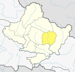
Dordi Rural Municipality is one of the local level rural municipalities of Lamjung District, of its 8 local municipalities.

It has 9 wards and according to census 2011, 18,392 people live in here.

It has 350.93 square km area.

Its center is in the office of the previous Nauthar V.D.C.

History

Previous Bharte V.D.C. (all wards), previous Archalbot V.D.C. (all wards), previous Shree Manjang V.D.C. (all wards), previous Nauthar V.D.C. (all wards), previous Pachowk V.D.C (all wards),previous Dhodeni V.D.C (all wards), previous Faleni V.D.C.(all wards),previous Bansar V.D.C. (all wards) and previous Hiletaksar V.D.C.(1, 2, 3, 4, 5, 6, 7 & 8 wards) are included in this newly made rural municipality.

Related Research Articles

<span class="mw-page-title-main">Gorkha District</span> District in Gandaki Province, Nepal

Gorkha District, a part of Gandaki Province, is one of the 77 districts of Nepal, and the fourth largest district of Nepal in terms of area. It is historically linked with the creation of modern Nepal and the name of the legendary Gorkha soldiers. The district, with Gorkha Municipality as its district headquarters, covers an area of 3,610 km2 (1,390 sq mi) and has a population of 252,201 according to the 2021 Nepal census. Gorkha district is the site of the Manakamana Temple. The temples of Gorakh Nath and Gorakh Kali are found in the district. Several major rivers—the Chepe, Daraudi, Marsyangdi, Budi Gandaki, and Trishuli—run through the district.

<span class="mw-page-title-main">Village development committee (Nepal)</span> Former lower administrative part of Nepals local development ministry

A village development committee in Nepal was the lower administrative part of its Ministry of Federal Affairs and Local Development. Each district had several VDCs, similar to municipalities but with greater public-government interaction and administration. There were 3,157 village development committees in Nepal. Each village development committee was further divided into several wards depending on the population of the district, the average being nine wards.

<span class="mw-page-title-main">Takukot</span> Ward of Rural Municipality in Gandaki Province, Nepal

Takukot is a Ward of Barpak sulikot Rural Municipality in Gorkha District in the Gandaki Province of northern-central Nepal. At the time of the 1991 Nepal census it had a population of 4,234 and had 801 houses in the town.

Taple (ताप्ले) was a village development committee in Gorkha District in the Gandaki Zone of northern-central Nepal. At the time of the 1991 Nepal census, it had a population of 4,398 and had 5000 houses in the town Hindu Muslim.

Melung is a Rural municipality located within the Dolakha District of the Bagmati Province of Nepal. The municipality spans 86.54 square kilometres (33.41 sq mi) of area, with a total population of 20,210 according to a 2011 Nepal census.

<span class="mw-page-title-main">Majibari</span> Village in Gandaki Zone, Nepal

Majibari is a small village in Dudhpokhari VDC, in the east Lamjung.

<span class="mw-page-title-main">Dudhpokhari Rural Municipality</span>

Dudhpokhari Rural Municipality is one of the local levels of Lamjung District out of 8 local levels. It has 6 wards and according to census 2011, 10,975 people live in here. It has 153.33 square km area. Its center is in the office of previous Gauda V.D.C. Gorkha District is in the east, Dordi Rural Municipality is in the west, Dordi Rural Municipality is in the north and Rainas Municipality and Gorkha District are in the south of Dudhpokhari Rural Municipality. Previous Dudhpokhari V.D.C., previous Bichaur V.D.C., previous Ilampokhari V.D.C., previous Kolki V.D.C. and previous Gauda V.D.C are included in this newly made municipality.

<span class="mw-page-title-main">Marsyandi Rural Municipality</span>

Marsyandi Rural Municipality is one of eight municipalities in Lamjung District, Nepal. It has 9 wards and, according to the 2011 census, a population of 18,759 people. The municipality is 597.25 km2 (230.60 sq mi) in area, and its administrative center is in the office of the previous Bhulbhule V.D.C. Gorkha District and Dordi Rural Municipality are to the east, Kwhlosothar Rural Municipality and Kaski District are to the west, Manang District, Kaski District and Gorkha District are in the north, and Besisahar Municipality, Dordi Rural Municipality and Kwhlosothar Rural Municipality are to the south of Marsyandi Rural Municipality. Previous portions of Ghanpokhara V.D.C., Khudi V.D.C., Taghring V.D.C., Ghermu V.D.C., Bahundanda V.D.C, Bhulbhule V.D.C and Simpani V.D.C.(all wards) are included in this newly made rural municipality.

<span class="mw-page-title-main">Rural municipality (Nepal)</span> Nepalese administrative subdivisions

A gaunpalika is an administrative division in Nepal. The Ministry of Federal Affairs and Local Development dissolved the existing village development committees and announced the establishment of this new local body. It is a sub-unit of a district. There are currently 481 rural municipalities.

Jwalamukhi is a Gaupalika(Nepali: गाउपालिका ; gaupalika) in Dhading District in the Bagmati Zone of central Nepal. The local body was formed by merging four VDCs namely Khari, Dhola, Nepal, Maidi and Chainpur, Bagmati. Currently, it has a total of 7 wards. The population of the rural municipality is 23,966 according to the data collected on 2017 Nepalese local elections.Chairman of this rural municipality is Binod Timalsina and he belongs to Nepali Congress Party.

<span class="mw-page-title-main">Gaurishankar Rural Municipality</span> Place in Bagmati Province, Nepal

Gaurishankar, a part of Bagmati Province, Nepal, is a rural municipality located in Dolakha District. With Suri as its current official headquarters, the rural municipality consists of nine wards covers an area of 681.39 km² and has a population of 17,062 in 2011.

Kamal is a rural municipality (gaunpalika) out of seven rural municipality located in Jhapa District of Province No. 1 of Nepal. There are a total of 15 municipalities in Jhapa in which 8 are urban and 7 are rural.

Jhapa is a rural municipality (gaunpalika) out of seven rural municipality located in Jhapa District of Koshi Province] of Nepal. There are a total of 15 municipalities in Jhapa in which 8 are urban and 7 are rural.

<span class="mw-page-title-main">Nechasalyan Rural Municipality</span> Rural Municipality in Province No. 1, Nepal

Nechasalyan is a rural municipality, or gaunpalika, located in Solukhumbu District, Province No. 1, Nepal. Solukhumbu has eight municipalities in all; one is an urban municipality and the other seven are rural municipalities.

Harinagar is a rural municipality (gaunpalika) out of six rural municipality located in Sunsari District of Province No. 1 of Nepal. There are a total of 12 municipalities in Sunsari in which 6 are urban and 6 are rural.

Tsum Nubri Rural Municipality is a rural municipality situated at the borderline of nepal and china in Gorkha District in Gandaki Province of Nepal. It is divided into 7 wards.

Dharche Rural Municipality is a Gaunpalika in Gorkha District in Gandaki Province of Nepal. It is divided into 7 wards. On 12 March 2017, the government of Nepal implemented a new local administrative structure, with the implementation of the new local administrative structure, VDCs have been replaced with municipal and Village Councils. Dharche is one of these 753 local units.

Bhimsen Thapa Municipality is a Rural Municipality aka Gaunpalika in Gorkha District in Gandaki Province of Nepal. On 12 March 2017, the government of Nepal implemented a new local administrative structure, with the implementation of the new local administrative structure, VDCs have been replaced with Urban Municipality and Rural Municipality. Bhimsen Thapa is one of these 753 local units. It represents - Masel VDC for ward number 1, Tandrang VDC for ward number 2 and 3, Dhawa VDC for ward number 4, Baguwa VDC for ward number 5, Ashrang VDC for ward number 6, and Borlang VDC for ward number 7 and 8.

Arughat Rural Municipality is a Gaunpalika in Gorkha District in Gandaki Province of Nepal. It is divided into 10 wards. On 12 March 2017, the government of Nepal implemented a new local administrative structure, with the implementation of the new local administrative structure, VDCs have been replaced with municipal and Village Councils. Arughat is one of these 753 local units.

Shailung is a rural municipality located within the Dolakha District of the Bagmati Province of Nepal. The municipality spans 96.30 square kilometres (37.18 sq mi) of area, with a total population of 20,098 according to a 2011 Nepal census.

References