
The Gurung people, also called Tamu, are an ethnic group in the hills and mountains of central Nepal. They live in Manang, Mustang, Kaski, Lamjung, Parbat and Syangja Dhading Districts, with a population of 522,641 people as of 2011. They speak the Sino-Tibetan Gurung language.

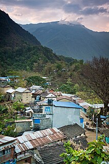
Lamjung District, a part of Gandaki Province, is one of the 77 districts of Nepal. The district, with Besisahar as its district headquarters, covers an area of 1,692 square kilometres (653 sq mi) and as of 2011 had a population of 167,724. Lamjung lies in the mid-hills of Nepal spanning tropical to trans-Himalayan geo-ecological belts, including the geographical midpoint of the country. It has mixed habitation of casts and ethnicities. It is host to probably the highest density of the Gurung ethnic population in the country.
Gurung language is spoken by the Gurung people of Nepal and in Sikkim, India. The total number of all Gurung speakers in Nepal was 227,918.
Bahundanda is a village development committee in Lamjung District in the Gandaki Zone of northern-central Nepal. At the time of the 1991 Nepal census it had a population of 2114 people living in 433 individual households.

Bichaur is a village development committee in Lamjung District in the Gandaki Zone of northern-central Nepal. At the time of the 1991 Nepal census it had a population of 2462 people living in 488 individual households.
Duradanda is one of the mid-hills in Lamjung District. Lamjung is one of districts in Gandaki in central Nepal. Duradanda used to have former six village development committees (VDCs) namely Chandreshwor, Duradanda, Dhuseni, Ishaneshwor, Neta, and Purankot. The new constitution has restructured the local bodies and these VDCs are formally non-existent. The name 'Duradanda' is composed of two terms: Dura= historical Dura tribes + danda= hill in Nepali. Duras inhabited this place from the historical times and were important political game players in the past, especially when Nepal was fragmented into 22–24 Kingdoms, known as Bayise Chaubisi rajyas. Duradanda is considered to be the place of origin of the 'Dura' tribe. Duras have their own language and culture but are being forgotten because of an increasing influence from other cultures. Dura language, in fact, is no longer in use as the tribe uses the Nepali language. Only old generations knows the language, and not many people of this generation are alive at this time. Thus, Dura language is in danger of being lost completely. Apart from Duras, Duradanda is also known for famous historical movements called 'Halo Kranti ' and 'Siksha Kranti '. Sarvodaya High School was one of the oldest school in the entire region of Central Nepal. Thus, people from very far places used to come to Duradanda for formal school education from Sarvodaya High School. At that time, young people who wanted to come here seeking school education from far villages used to say: "Duradanda kei chhaina tadha, janchhu ma ta sikshya ko khojima" meaning that "Duradanda is no longer far and I want to go there seeking my education". There were no hostels, so the youngesters used to live as guests in locals' houses, preferably relatives. In return, they had to bring commodities or to provide labor services for household and/or farm works.
Gauda, Nepal is a village development committee in Lamjung District in the Gandaki Zone of northern-central Nepal. At the time of the 1991 Nepal census it had a population of 3325 people living in 650 individual households.
Ilampokhari is a village development committee in Lamjung District in the Gandaki Zone of northern-central Nepal. At the time of the 1991 Nepal census it had a population of 3197 people living in 620 individual households.
Khudi, Nepal is a village development committee in Lamjung District in the Gandaki Zone of northern-central Nepal. At the time of the 1991 Nepal census it had a population of 3212 people living in 664 individual households.
Kolki is a village development committee in Lamjung District in the Gandaki Zone of northern-central Nepal. At the time of the 1991 Nepal census it had a population of 1892 people living in 354 individual households.
Maling is a village development committee in Lamjung District in the Gandaki Zone of northern-central Nepal. At the time of the 1991 Nepal census it had a population of 1745 people living in 337 individual households.
Mohoriyakot is a village development committee in Lamjung District in the Gandaki Zone of northern-central Nepal. At the time of the 1991 Nepal census it had a population of 2564 people living in 512 individual households.
Parewadanda is a village development committee in Lamjung District in the Gandaki Zone of northern-central Nepal. At the time of the 1991 Nepal census it had a population of 2633 people living in 528 individual households.
Pyarjung is a village development committee in Lamjung District in the Gandaki Zone of northern-central Nepal. At the time of the 1991 Nepal census it had a population of 2256 people living in 443 individual households.
Ramgha is a former village development committee now changed into MadhyaNepal Municipality in Lamjung District in the Gandaki Zone of northern-central Nepal. According to Geologist Dr.Harka Gurung this area lies in the centroid of Nepal.At the time of the 1991 Nepal census it had a population of 2327 people living in 446 individual households.
Tandrang, Lamjung is a village development committee in Lamjung District in the Gandaki Zone of northern-central Nepal. At the time of the 1991 Nepal census it had a population of 2293 people living in 453 individual households.
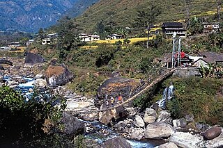
Tarkughat is a village development committee in Lamjung District in the Gandaki Zone of northern-central Nepal. At the time of the 1991 Nepal census it had a population of 2650 people living in 536 individual households. This village lies at the bank of Marsyangdi river.
Bhotewodar, one of the main cities of Lamjung District. Which is identified as the gateway of East Lamjung lies in the Gandaki zone, Nepal. It was named as Bhotewodar as there was a cave (odhar) in this place where Bhotes used to take shelter during the winter time and used to sell their goods. So, it was named as Bhotewodar later. It has three government schools and three private boarding schools. Bhakti Namuna Secondary School was established in 2024 B.S. Students can get education up to diploma level herein. It has got all kind of facilities like electricity, transportation, communication, health and so on. The climate is very fine to settle. It lies near the Marsyangdi river. It has Middle Marsyangdi Hydropower House. Newars are the first inhabitants of this place. Later on people from Gurung community, Brahmin community, Chhetri community also have settled here. At the time of the 2001 Nepal census it had a population of 5897.

Gandaki Province is one of the seven federal provinces established by the current constitution of Nepal which was promulgated on 20 September 2015. Pokhara is the province's capital city. It borders the Tibet Autonomous Region of China to the north, Bagmati Province to the east, Karnali Province to the west, and Lumbini Province and Bihar of India to the south. The total area of the province is 21,504 km² - about 14.57% of the country's total area. According to the latest census, the population of the province was 2,403,757. The newly elected Provincial Assembly adopted Gandaki Province as the permanent name by replacing its initial name Province no. 4 in July 2018. Krishna Chandra Nepali is the present chief minister of Gandaki province
Tandrange is a Sino-Tibetan language spoken in a few ethnic Gurung villages of Lamjung District, Nepal. Tandrange is spoken in the villages of Tāndrāṅ (तान्द्राङ), Pokharī Thok, and Jītā (जीता). It belongs to the Greater Magaric branch of the Sino-Tibetan language family.


