
The Gurung people, also called Tamu, are an ethnic group in the hills and mountains of central Nepal. They live in Manang, Mustang, Kaski, Lamjung, Parbat and Syangja Dhading Districts, with a population of 522,641 people as of 2011. They speak the Sino-Tibetan Gurung language.

Lamjung District, a part of Gandaki Province, is one of the 77 districts of Nepal. The district, with Besisahar as its district headquarters, covers an area of 1,692 square kilometres (653 sq mi) and as of 2011 had a population of 167,724. Lamjung lies in the mid-hills of Nepal spanning tropical to trans-Himalayan geo-ecological belts, including the geographical midpoint of the country. It has mixed habitation of casts and ethnicities. It is host to probably the highest density of the Gurung ethnic population in the country.

Besishahar is a municipality and the district headquarters of Lamjung District in Gandaki Province, Nepal. The Besishahar Municipality was formed by merging the existing Village Development Committees i.e. Besishahar, Gaunshahar, Udipur, Chandisthan, Baglungpani, Bajhakhet, Hiletaksar and Chiti and have 11 wards. Here are different castes and religions. So they have different culture. This municipality has a sub-tropical climate with deciduous forests. Annapurna II, Machhapuchhre, Lamjung Himal can be viewed from north of Besishahar Municipality.

Bichaur is a village development committee in Lamjung District in the Gandaki Zone of northern-central Nepal. At the time of the 1991 Nepal census it had a population of 2462 people living in 488 individual households.
Chandisthan is a town and market place at Besishahar Municipality in Lamjung District in Gandaki Province of northern-central Nepal. The Besishahar Municipality was formed by merging the existing Village Development Committees i.e. Besishahar, Gaunshahar, Udipur & Chandisthan in 15 May 2014.
Chiti is a village and the 11th ward of Besisahar Municipality in Lamjung District in the Gandaki Province of northern-central Nepal. It is also a former village development committee of Lamjung District out of 61. At the time of the 2011 Nepal census it had a population of 5166, and it covers the area of 17.62 square kilometer.
Gauda, Nepal is a village development committee in Lamjung District in the Gandaki Zone of northern-central Nepal. At the time of the 1991 Nepal census it had a population of 3325 people living in 650 individual households.

Gaunshahar is a town and market place at Besishahar Municipality in Lamjung District in Gandaki Province of northern-central Nepal. The Besishahar Municipality was formed by merging the existing Village Development Committees i.e. Besishahar, Gaunshahar, Udipur & Chandisthan on May 15, 2014. The temple of Lamjung Kalika & Lamjung Durbar are located here. This place is in the way of Annapurna Conservation Area. The Dumre-Besishahar-Chame highway also goes from this place. Here are different casts and religions.
Ilampokhari is a village development committee in Lamjung District in the Gandaki Zone of northern-central Nepal. At the time of the 1991 Nepal census it had a population of 3197 people living in 620 individual households.
Khudi, Nepal is a village development committee in Lamjung District in the Gandaki Zone of northern-central Nepal. At the time of the 1991 Nepal census it had a population of 3212 people living in 664 individual households.
Kolki is a village development committee in Lamjung District in the Gandaki Zone of northern-central Nepal. At the time of the 1991 Nepal census it had a population of 1892 people living in 354 individual households.
Maling is a village development committee in Lamjung District in the Gandaki Zone of northern-central Nepal. At the time of the 1991 Nepal census it had a population of 1745 people living in 337 individual households.
Mohoriyakot is a village development committee in Lamjung District in the Gandaki Zone of northern-central Nepal. At the time of the 1991 Nepal census it had a population of 2564 people living in 512 individual households.
Nalma is a village development committee in Lamjung District in the Gandaki Zone of northern-central Nepal. At the time of the 1991 Nepal census it had a population of 2082 people living in 409 individual households. The villages of Nalma VDC are as follows:
- Jyarkhang
- Bakhrijagat
- Syare, Lausibot, Kochme
- Puran Gaun
- Gairi Gaun
- Danda Gaun
- Bartu
- Chodo khora
- Fedi
- Ramche Khola
Parewadanda is a village development committee in Lamjung District in the Gandaki Zone of northern-central Nepal. At the time of the 1991 Nepal census it had a population of 2633 people living in 528 individual households.
Pyarjung is a village development committee in Lamjung District in the Gandaki Zone of northern-central Nepal. At the time of the 1991 Nepal census it had a population of 2256 people living in 443 individual households.
Sundarbazar is a Municipality in Lamjung District in the Gandaki Province of northern-central Nepal. The Sundarbazar Municipality was formed by merging the existing Village Development Committees i.e. Bhoteodar, Sundarbazar, Parewadanda, Tarku and Kuncha as one of the 61-municipalities category on 2071. As of 2011 Nepal census, it had 11,230 male population and 15,445 female population living in 7,512 households.

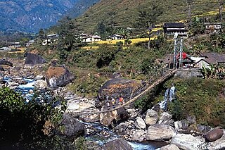
Udipur is a town and market place at Besishahar Municipality in Lamjung District in the Gandaki Zone of northern-central Nepal. The Besishahar Municipality was formed by merging the existing Village Development Committees i.e. Besishahar, Gaunshahar, Udipur & Chandisthan on May 15, 2014. Middle Marshyandi Hydro Electricity is located in this place. The famous temple of Udipur Kalika is located here. This place is in the way of Annapurna Conservation Area. The Dumre-Besishahar-Chame highway also goes from this place. Here are different casts and religions.

Rainas is a municipality of Lamjung District in Gandaki Province of central Nepal. The municipality was declared on 19 September 2015 by merging the existing six VDCs of Eastern Lamjung, Tarkughat, Dhamilikuwa, Chakratirtha, Bhalayakharka, Pyarjung and Mohoriyakot having a total of 73 square km area. The center of this municipality has been established in Tinpiple of Chakratirth VDC. Rainas has a total population of 18,527 and population density of 254 person/km2 according to 2011 Nepal census.

Gandaki Province is one of the seven federal provinces established by the current constitution of Nepal which was promulgated on 20 September 2015. Pokhara is the province's capital city. It borders the Tibet Autonomous Region of China to the north, Bagmati Province to the east, Karnali Province to the west, and Lumbini Province and Bihar of India to the south. The total area of the province is 21,504 km² - about 14.57% of the country's total area. According to the latest census, the population of the province was 2,403,757. The newly elected Provincial Assembly adopted Gandaki Province as the permanent name by replacing its initial name Province no. 4 in July 2018. Krishna Chandra Nepali is the present chief minister of Gandaki province


