Dudhpokhari Rural Municipality

Last updated

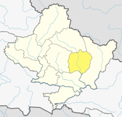
Dudhpokhari Rural Municipality is one of the local levels of Lamjung District out of 8 local levels. [1] It has 6 wards and according to census 2011, 10,975 people live in here. It has 153.33 square km area. Its center is in the office of previous Gauda V.D.C. Gorkha District is in the east, Dordi Rural Municipality is in the west, Dordi Rural Municipality is in the north and Rainas Municipality and Gorkha District are in the south of Dudhpokhari Rural Municipality. Previous Dudhpokhari V.D.C. (all wards), previous Bichaur V.D.C. (all wards), previous Ilampokhari V.D.C. (all wards), previous Kolki V.D.C. (all wards) and previous Gauda V.D.C (all wards) are included in this newly made municipality.

Related Research Articles

<span class="mw-page-title-main">Lamjung District</span> District in Gandaki Province, Nepal

Lamjung District, a part of Gandaki Province, is one of the 77 districts of Nepal. The district, with Besisahar as its district headquarters, covers an area of 1,692 square kilometres (653 sq mi) and as of 2011 had a population of 167,724. Lamjung lies in the mid-hills of Nepal spanning tropical to trans-Himalayan geo-ecological belts, including the geographical midpoint of the country. It has mixed habitation of casts and ethnicities. It is host to probably the highest density of the Gurung ethnic population in the country.

<span class="mw-page-title-main">Administrative divisions of Nepal</span> Subnational administrative units of Nepal

The administrative divisions of Nepal are subnational administrative units of Nepal. The first level of country subdivision of Nepal are the provinces. Each province is further subdivided into districts, each district into municipalities and rural municipalities, and each of those municipalities into wards. Before 2015, instead of provinces, Nepal was divided into developmental regions and administrative zones.

<span class="mw-page-title-main">Ilam Municipality</span> Municipality in Koshi Province, Nepal

Ilam is one of four urban municipalities of Ilam District, which lies in the Mahabharata hilly range of Koshi Province, eastern Nepal. Ilam also acts as the headquarters of Ilam District. Being the largest producer region for Nepali tea, its tea farms are a major tourist attraction in Koshi Province. Ilam is also famous for its natural scenery and landscapes as well as its diverse agricultural economy which specializes in horticultural crop production.

<span class="mw-page-title-main">Besishahar</span> Municipality in Gandaki Province, Nepal

Besishahar is a municipality and the district headquarters of Lamjung District in Gandaki Province, Nepal. The Besishahar Municipality was formed by merging the existing Village Development Committees i.e. Besishahar, Gaunshahar, Udipur, Chandisthan, Baglungpani, Bajhakhet, Hiletaksar and Chiti and have 11 wards. This municipality has a sub-tropical climate with deciduous forests. Annapurna II, Machhapuchhre, Lamjung Himal can be viewed from north of Besishahar Municipality.

<span class="mw-page-title-main">Village development committee (Nepal)</span> Former lower administrative part of Nepals local development ministry

A village development committee in Nepal was the lower administrative part of its Ministry of Federal Affairs and Local Development. Each district had several VDCs, similar to municipalities but with greater public-government interaction and administration. There were 3,157 village development committees in Nepal. Each village development committee was further divided into several wards depending on the population of the district, the average being nine wards.

Dudhpokhari (दूधपोखरी) is a village development committee in Lamjung District in the Gandaki Province of northern-central Nepal. The name Dudhpokhari is derived from the lake which lies in the base of Himalchuli. At the time of the 2011 Nepal census it had a population of 10,975 people living in 2590 individual households. The highest elevation is Mount Himalchuli. Dudhpokhari kunda, which lies in the base of himalchuli, is a popular religious destination which attracts thousand of Hindus in Shrawan during Janai Purnima.

Kolki is a village development committee in Lamjung District in the Gandaki Zone of northern-central Nepal. At the time of the 1991 Nepal census it had a population of 1892 people living in 354 individual households.

Gunjanagar is a town in Bharatpur, Chitwan in Bagmati Province of southern Nepal. The former Gunjanagar VDC and Saradanagar VDC were merged on 18 May 2014 to form new Chitrawan Municipality, which later was merged with Bharatpur. At the time of the 1991 Nepal census it had a population of 11,076 people living in 2025 individual households.

<span class="mw-page-title-main">Tinpiple, Lamjung</span> Municipality in Gandaki Zone, Nepal

Tinpiple is situated near the Chepe River. The Chepe River is the borderline between the Gorkha and Lamjung districts and originates in Dudhpokhari. The river has a long historical background and is seen as a sign of love and affection as well as the barrier to brotherhood.

<span class="mw-page-title-main">Majibari</span> Village in Gandaki Zone, Nepal

Majibari is a small village in Dudhpokhari VDC, in the east Lamjung.

Madhyanepal is a municipality located in Lamjung District in Gandaki Province of Nepal. It is one of four municipalities located in Lamjung.

Dordi Rural Municipality is one of the local level rural municipalities of Lamjung District, of its 8 local municipalities.

<span class="mw-page-title-main">Kwhlosothar Rural Municipality</span> Gaupalika in Gandaki Province, Nepal

Kwbholasothar is a rural municipality located in the Lamjung District of Gandaki Province, central Nepal. It was formed on 10 March 2017 as part of the new local administrative structure, which comprises 744 local units. Kwbholasothar, a local municipal unit in Lamjung is created by merging wards 1, 2, 5, 6 of Balungpani, Maling, Uttarkanya, Bhujung, Pasagaun, Bhoje, and Gilung. The municipality has a total population of 10,032 and covers an area of 175.37 km2. It is divided into 9 wards, with the administrative center situated in the former Maling V.D.C. Kwbholasothar is bordered by Besisahar Municipality and Marsyandi Rural Municipality to the east, Kaski District to the west, and Marsyandi Rural Municipality, Kaski District, Madhyanepal Municipality, and Besishahar Municipality to the north and south, respectively.

<span class="mw-page-title-main">Marsyandi Rural Municipality</span>

Marsyandi Rural Municipality is one of eight municipalities in Lamjung District, Nepal. It has 9 wards and, according to the 2011 census, a population of 18,759 people. The municipality is 597.25 km2 (230.60 sq mi) in area, and its administrative center is in the office of the previous Bhulbhule V.D.C. Gorkha District and Dordi Rural Municipality are to the east, Kwhlosothar Rural Municipality and Kaski District are to the west, Manang District, Kaski District and Gorkha District are in the north, and Besisahar Municipality, Dordi Rural Municipality and Kwhlosothar Rural Municipality are to the south of Marsyandi Rural Municipality. Previous portions of Ghanpokhara V.D.C., Khudi V.D.C., Taghring V.D.C., Ghermu V.D.C., Bahundanda V.D.C, Bhulbhule V.D.C and Simpani V.D.C.(all wards) are included in this newly made rural municipality.

Budhiganga is a Gaupalika out of eight rural municipality located at Morang district of Province No. 1 of Nepal. There are a total of 17 local body in Morang District in which 1 is metro city, 7 are urban municipality and 7 are rural municipality.

Harinagar is a rural municipality (gaunpalika) out of six rural municipality located in Sunsari District of Province No. 1 of Nepal. There are a total of 12 municipalities in Sunsari in which 6 are urban and 6 are rural.

Chumanuwri is a Gaunpalika in Gorkha District in Gandaki Province of Nepal. It is divided into 7 wards.

Bhimsen Thapa Municipality is a Rural Municipality aka Gaunpalika in Gorkha District in Gandaki Province of Nepal. On 12 March 2017, the government of Nepal implemented a new local administrative structure, with the implementation of the new local administrative structure, VDCs have been replaced with Urban Municipality and Rural Municipality. Bhimsen Thapa is one of these 753 local units. It represents - Masel VDC for ward number 1, Tandrang VDC for ward number 2 and 3, Dhawa VDC for ward number 4, Baguwa VDC for ward number 5, Ashrang VDC for ward number 6, and Borlang VDC for ward number 7 and 8.

Shailung is a rural municipality located within the Dolakha District of the Bagmati Province of Nepal. The municipality spans 96.30 square kilometres (37.18 sq mi) of area, with a total population of 20,098 according to a 2011 Nepal census.

References

  1. "EHRP Nepal: Lamjung Inspection Dashboard". National Reconstruction Authority . Retrieved 2021-03-27.