
Bajura District, a part of Sudurpashchim Province, is one of the seventy-seven districts of Nepal. The district, with Martadi as its district headquarters, covers an area of 2,188 km2 (845 sq mi) and had a population of 108,781 in 2001 and 134,912 in 2011. The district has nine municipalities, 9 Ilakas and 1 constituency areas. The district is situated in Longitude between 81° 10′ 20″ to 81° 48′ 27″ East and Latitude 29° 16′ 21″ to 29° 56′ 56″ North. Geographically the district is divided in three distinct regions from north to south viz. Higher Himalayan Region, Higher Mountain and mid – Mountains. The Higher Himalayan region comprises Saipal Himalayan range; High Mountain region comprises Doha Lekh and Ghori Lekh. Similarly, Mid-Mountain range comprises different ranges of mountains e.g. Badimalika Temple. The District has started from 300m to 6400m in height. The annual rainfall is about 13,433 mm and temperatures vary from 0 °C to 40 °C. The livelihood of more than 80% of the district population depends on agriculture farming, mainly small scale livestock. Due to low level of agricultural production, the majority of the households face acute food shortages for a large part of the year. According to the National Census 2011, the total population of the district is 134,912 comprising 69,106 female (51%) and 65,806 male (49%) residing in 24,908 households. Bajura district has an average population density of around 62 people per square km. The average family size is 5.4. Life expectancy of the people is 58 years. The average literacy rate is about 32%. Bajura district has a multi ethnic composition with Chhetri, Kami, Thakuri, Brahman, Damai, SarkI and Sanyashi. The common language is Nepali (96%) followed by Bhote Sherpa (0.46%) and Tamang (0.42%). Although accessibility to Bajura is very poor, this is improving rapidly. The Government strategy is mainly focused on the connection of VDC headquarters with all-weather motor able roads to SRN or District headquarters. Moreover, the DDC body of Bajura district has given higher priority on rural roads.

Darchula District (Nepali: दार्चुला जिल्लाpronounced [ˈdaɾt͡sula], a part of Sudurpashchim Province, is one of the nine districts of province and one of seventy-seven districts of Nepal. The district, with Khalanga as its district headquarters, covers an area of 2,322 km2 and has a population of 133,274. Darchula Lies in the west-north corner of the country.

Lamjung District, a part of Gandaki Province, is one of the 77 districts of Nepal. The district, with Besisahar as its district headquarters, covers an area of 1,692 square kilometres (653 sq mi) and as of 2011 had a population of 167,724. Lamjung lies in the mid-hills of Nepal spanning tropical to trans-Himalayan geo-ecological belts, including the geographical midpoint of the country. It has mixed habitation of casts and ethnicities. It is host to probably the highest density of the Gurung ethnic population in the country.

Inaruwa is a municipality and headquarters of Sunsari District located 25 km (16 mi) east of the Koshi Barrage and 18.6 km (11.6 mi) east of Koshi Tappu Wildlife Reserve in Province No. 1, Nepal. It covers an area of 77.92 km2 (30.09 sq mi).

Besishahar is a municipality and the district headquarters of Lamjung District in Gandaki Province, Nepal. The Besishahar Municipality was formed by merging the existing Village Development Committees i.e. Besishahar, Gaunshahar, Udipur, Chandisthan, Baglungpani, Bajhakhet, Hiletaksar and Chiti and have 11 wards. Here are different castes and religions. So they have different culture. This municipality has a sub-tropical climate with deciduous forests. Annapurna II, Machhapuchhre, Lamjung Himal can be viewed from north of Besishahar Municipality.

Bichaur is a village development committee in Lamjung District in the Gandaki Zone of northern-central Nepal. At the time of the 1991 Nepal census it had a population of 2462 people living in 488 individual households.
Chandisthan is a town and market place at Besishahar Municipality in Lamjung District in Gandaki Province of northern-central Nepal. The Besishahar Municipality was formed by merging the existing Village Development Committees i.e. Besishahar, Gaunshahar, Udipur & Chandisthan in 15 May 2014.
Duradanda is one of the mid-hills in Lamjung District. Lamjung is one of districts in Gandaki in central Nepal. Duradanda used to have former six village development committees (VDCs) namely Chandreshwor, Duradanda, Dhuseni, Ishaneshwor, Neta, and Purankot. The new constitution has restructured the local bodies and these VDCs are formally non-existent. The name 'Duradanda' is composed of two terms: Dura= historical Dura tribes + danda= hill in Nepali. Duras inhabited this place from the historical times and were important political game players in the past, especially when Nepal was fragmented into 22–24 Kingdoms, known as Bayise Chaubisi rajyas. Duradanda is considered to be the place of origin of the 'Dura' tribe. Duras have their own language and culture but are being forgotten because of an increasing influence from other cultures. Dura language, in fact, is no longer in use as the tribe uses the Nepali language. Only old generations knows the language, and not many people of this generation are alive at this time. Thus, Dura language is in danger of being lost completely. Apart from Duras, Duradanda is also known for famous historical movements called 'Halo Kranti ' and 'Siksha Kranti '. Sarvodaya High School was one of the oldest school in the entire region of Central Nepal. Thus, people from very far places used to come to Duradanda for formal school education from Sarvodaya High School. At that time, young people who wanted to come here seeking school education from far villages used to say: "Duradanda kei chhaina tadha, janchhu ma ta sikshya ko khojima" meaning that "Duradanda is no longer far and I want to go there seeking my education". There were no hostels, so the youngesters used to live as guests in locals' houses, preferably relatives. In return, they had to bring commodities or to provide labor services for household and/or farm works.
Gauda, Nepal is a village development committee in Lamjung District in the Gandaki Zone of northern-central Nepal. At the time of the 1991 Nepal census it had a population of 3325 people living in 650 individual households.

Gaunshahar is a town and market place at Besishahar Municipality in Lamjung District in Gandaki Province of northern-central Nepal. The Besishahar Municipality was formed by merging the existing Village Development Committees i.e. Besishahar, Gaunshahar, Udipur & Chandisthan on May 15, 2014. The temple of Lamjung Kalika & Lamjung Durbar are located here. This place is in the way of Annapurna Conservation Area. The Dumre-Besishahar-Chame highway also goes from this place. Here are different casts and religions.
Ilampokhari is a village development committee in Lamjung District in the Gandaki Zone of northern-central Nepal. At the time of the 1991 Nepal census it had a population of 3197 people living in 620 individual households.
Khudi, Nepal is a village development committee in Lamjung District in the Gandaki Zone of northern-central Nepal. At the time of the 1991 Nepal census it had a population of 3212 people living in 664 individual households.
Kolki is a village development committee in Lamjung District in the Gandaki Zone of northern-central Nepal. At the time of the 1991 Nepal census it had a population of 1892 people living in 354 individual households.
Mohoriyakot is a village development committee in Lamjung District in the Gandaki Zone of northern-central Nepal. At the time of the 1991 Nepal census it had a population of 2564 people living in 512 individual households.
Nalma is a village development committee in Lamjung District in the Gandaki Zone of northern-central Nepal. At the time of the 1991 Nepal census it had a population of 2082 people living in 409 individual households. The villages of Nalma VDC are as follows:
- Jyarkhang
- Bakhrijagat
- Syare, Lausibot, Kochme
- Puran Gaun
- Gairi Gaun
- Danda Gaun
- Bartu
- Chodo khora
- Fedi
- Ramche Khola
Pyarjung is a village development committee in Lamjung District in the Gandaki Zone of northern-central Nepal. At the time of the 1991 Nepal census it had a population of 2256 people living in 443 individual households.

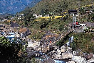
Udipur is a town and market place at Besishahar Municipality in Lamjung District in the Gandaki Zone of northern-central Nepal. The Besishahar Municipality was formed by merging the existing Village Development Committees i.e. Besishahar, Gaunshahar, Udipur & Chandisthan on May 15, 2014. Middle Marshyandi Hydro Electricity is located in this place. The famous temple of Udipur Kalika is located here. This place is in the way of Annapurna Conservation Area. The Dumre-Besishahar-Chame highway also goes from this place. Here are different casts and religions.
Hariwan Municipality is one of the new municipalities declared by the Government of Nepal on May 18, 2014. It is located in Sarlahi District Janakpur zone, Nepal. It is formed by the joining of four contemporary Village development committees (VDCs) namely Atrouli, Sasapur, Ghurkauli and Harion VDCs covering an area of 88.1 km2. It has been divided into 11 wards with an administration center in Harion Bazar. According to Nepal Population Census 2011, the municipality has a total population of 42,783.
Lalbandi is a Municipality in Sarlahi District in the Janakpur Zone of south-eastern Nepal. The municipality was established on 18 May 2014 by merging the existing Parwanipur VDC, Netragung vdc, Jabdi, Lalbandi and Pattharkot VDCs. At the time of the 2011 Nepal Census, it had a population of 59,395 people living in 3,295 individual households. There are 17 wards in this municipality. It is the largest municipality in Sarlahi district. The office of this municipality is in ward no.6 Located in the Lalbandi. Lalbandi Bazar, located on the East West Mahendra highway, is one of the main trading areas within the municipal area. Bordering East Ishwarpur Municipality, West Hariwan and Haripur Municipality, North Sindhuli District and bordering Haripur and Ishwarpur in the south, Lalbandi Bazar is the main trading site of the district.
Gadhimai is a municipality in Rautahat district of Narayani zone, Nepal. It lies at the border of Rautahat district that links Sarlahi District over Bagmati River. It was formed by merging former 6 Village development committees Gamhariya, samanpur, Sangrampur, Bahuwa Madanpur, Dharampur and Bariyarpur just before 2017 Nepalese local elections.


