
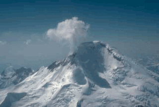
Redoubt Volcano, or Mount Redoubt, is an active stratovolcano in the largely volcanic Aleutian Range of the U.S. state of Alaska. Located at the head of the Chigmit Mountains subrange in Lake Clark National Park and Preserve, the mountain is just west of Cook Inlet, in the Kenai Peninsula Borough about 110 miles (180 km) southwest of Anchorage. At 10,197 feet (3,108 m), in just over 5 miles (8.0 km) Mount Redoubt attains 9,150 feet (2,790 m) of prominence over its surrounding terrain. It is the highest summit in the Aleutian Range. In 1976, Redoubt Volcano was designated as a National Natural Landmark by the National Park Service.
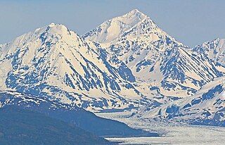
Iliamna Volcano, or Mount Iliamna, is a glacier-covered stratovolcano in the largely volcanic Aleutian Range in southwest Alaska. Located in the Chigmit Mountain subrange in Lake Clark National Park and Preserve, the 10,016-foot (3,053 m) volcano lies approximately 134 miles (215 km) southwest of Anchorage on the west side of lower Cook Inlet. It is the 25th most prominent peak in the United States.

Mount Hayes is the highest mountain in the eastern Alaska Range, in the U.S. state of Alaska. Despite not being a fourteener, it is one of the largest peaks in the United States in terms of rise above local terrain. For example, the Northeast Face rises 8,000 feet (2,440 m) in approximately 2 miles (3.2 km). This large vertical relief contributes to Mount Hayes being the 51st most topographically prominent peak in the world.

The Chigmit Mountains are a subrange of the Aleutian Range in the Kenai Peninsula and Lake and Peninsula Boroughs of the U.S. state of Alaska.

Pioneer Peak is a 6,398-foot (1,950 m) mountain in the Chugach Mountains in the U.S. state of Alaska. Located beside the Knik River just nine miles (14.5 km) south of Palmer and about six miles outside the Municipality of Anchorage limits, it is a prominent landmark in the Matanuska-Susitna Valley, as well as a popular hiking destination. Its Ahtna name means "the object is standing still" and its Dena'ina name means "the one that watches us". The name was given in 1939 in honor of the pioneers of the Matanuska agricultural colony of the mid-1930s. The Pioneer Ridge Trail leads up the eastern shoulder, beginning below 200', it allows access to the South summit. The North summit, and true summit of Pioneer Peak does not have a trail, and advanced mountaineering techniques are required. The first ascent of this peak was made June 1936 by Vernon Haik and John Wolffe via the Northwest Face.
Mount Abbe is an 8200+ feet double summit mountain located in the Fairweather Range of the Saint Elias Mountains, in southeast Alaska. The peak is situated near the terminus of the Johns Hopkins Glacier, within Glacier Bay National Park and Preserve, 100 mi (161 km) northwest of Juneau, and 8.2 mi (13 km) northeast of Mount Orville. Although modest in elevation, relief is significant since the mountain rises up from tidewater in less than two miles. Mount Abbe is often seen and photographed with the Johns Hopkins Glacier, which is a popular destination for cruise ships. The mountain was named in 1936 by William Osgood Field and William Skinner Cooper, of the American Geographical Society, for Cleveland Abbe Jr., (1872-1934), an American geographer. Abbe received a Ph.D. in 1898 from Johns Hopkins University. The Gilman Glacier and Clark Glacier on the mountain's slopes were named for Daniel Coit Gilman, the institution's first president, and William Bullock Clark who was a professor of geology at the university. The mountain's name was officially adopted in 1937 by the United States Geological Survey. The first ascent of the south summit was made June 11, 1977, by Jim Wickwire and Dusan Jagersky via the Southeast Face. Three days later, Dusan Jagersky was killed while descending an unnamed peak. The first ascent of the north summit was made July 14, 1991, by Walter Gove and William Pilling. The months May through June offer the most favorable weather for climbing Mount Abbe, but it's a challenging climb in any conditions, with few attempts.
Mount Abdallah is a prominent 6,210-foot (1,893-meter) mountain summit located in the Alsek Ranges of the Saint Elias Mountains, in southeast Alaska. The mountain is situated in Glacier Bay National Park and Preserve, as the highest point between Tarr Inlet and Rendu Inlet, 93 mi (150 km) northwest of Juneau, and 10.5 mi (17 km) southeast of Mount Barnard, which is the nearest higher peak. Although modest in elevation, relief is significant since the mountain rises up from tidewater in less than three miles. The mountain was named in 1892 by Harry Fielding Reid, an American geophysicist, who in 1892 hired a small crew of men for an expedition to study glaciology in Glacier Bay. There is no record of who Reid named this mountain for, but a member of his expeditionary crew who accompanied him might be a possibility. The months May through June offer the most favorable weather for viewing Mount Abdallah. Weather permitting, Mount Abdallah can be seen from Glacier Bay, which is a popular destination for cruise ships.
Mount Gilbert is a prominent 9,638-foot (2,938 m) glaciated mountain summit located in the Chugach Mountains, in the U.S. state of Alaska. The peak is situated 54 mi (87 km) east of Anchorage, 32 mi (51 km) northeast of Whittier, and 5.8 mi (9 km) northeast of Mount Muir, on land managed by Chugach National Forest. Although modest in elevation, relief is significant since the mountain rises up from tidewater at Harriman Fjord in Prince William Sound in less than six miles.

Mount Case is a prominent 5,545-foot (1,690 m) mountain summit located in the Alsek Ranges of the Saint Elias Mountains, in southeast Alaska. The mountain is situated in Glacier Bay National Park and Preserve, as the highest point between Adams Inlet and White Glacier, 65 mi (105 km) northwest of Juneau, and 2.47 mi (4 km) northeast of Mount Wright, which is the nearest peak. Although modest in elevation, relief is significant as the mountain rises up from tidewater in less than three miles, and it ranks 73rd in prominence for all peaks in Alaska. The mountain was named in 1890 by Harry Fielding Reid, an American geophysicist, who studied glaciology in Glacier Bay. Reid named this mountain for his school, the Case School of Applied Science, in Cleveland, Ohio. The months May through June offer the most favorable weather for viewing or climbing Mount Case. Weather permitting, Mount Case can be seen from Glacier Bay, which is a popular destination for cruise ships.

Black Mountain is a prominent, 5,891-foot-high (1,796-meter) mountain summit located in the Alsek Ranges of the Saint Elias Mountains in southeast Alaska. The mountain is situated in Glacier Bay National Park and Preserve, 75 mi (121 km) northwest of Juneau, between the Riggs and McBride glaciers. The months May through June offer the most favorable weather for viewing or climbing Black Mountain. Weather permitting, Black Mountain can be seen from Muir Inlet of Glacier Bay, which is a popular destination for cruise ships.

Mount Tom White is a prominent 11,191-foot glaciated mountain summit located in the Chugach Mountains, in the U.S. state of Alaska. The remote peak is situated on land managed by Chugach National Forest, 72 mi (116 km) northeast of Cordova, and 20 mi (32 km) north of the Bering Glacier, North America's largest glacier. The mountain lies within the Copper River drainage basin, and is the eighth-highest major peak in the Chugach Mountains. Topographic relief is significant as it ranks 17th in prominence for all peaks in Alaska, and 52nd for all North America peaks. The first ascent of the mountain was made in 1973 by Story Clark, Chris Hall, Tom Kizzia, William Resor, Sarah Robey, and Don White.

Black Peak is a prominent 6,385 ft-high (1,946 m) glaciated mountain summit located in Lake Clark National Park and Preserve, in the Chigmit Mountains of the Aleutian Range, in the US state of Alaska. It is the second-highest non-volcanic peak in the Chigmit Mountains, and fourth-highest overall. The mountain is situated 22 mi (35 km) west of Cook Inlet, 90 mi (145 km) west-southwest of Anchorage, and 10.2 mi (16 km) northeast of Double Peak, which is the nearest higher peak. Although modest in elevation, relief is significant since the mountain rises up 6,200 ft (1,900 m) from North Fork Big River in about two miles. The mountain's descriptive name was published in 1912 by the United States Coast and Geodetic Survey. The months May through June offer the most favorable weather for viewing or climbing the peak.

Mount Huxley is a 12,216-foot glaciated mountain summit located in the Saint Elias Mountains of Wrangell-St. Elias National Park and Preserve, in the U.S. state of Alaska. The remote peak is situated 75 mi (121 km) northwest of Yakutat, and 8.7 mi (14 km) west-northwest of Mount Saint Elias. The peak rises above the Columbus Glacier and Bagley Icefield to its north, the Tyndall Glacier to the south, and the Yahtse Glacier to the west. Precipitation runoff from the mountain drains into the Gulf of Alaska. The mountain was named in 1886 by English mountaineer Harold Ward Topham for Thomas Henry Huxley (1825-1895), an English biologist. The mountain was officially named Huxley Peak in 1917, but the name was officially changed to Mount Huxley in 1968 by the U.S. Board on Geographic Names. The first ascent of the peak was made June 9, 1996 by Paul Claus who landed his plane at 11,500 feet elevation on the western flank and climbed the remaining distance to the summit. The second ascent of Mt. Huxley, and first complete ascent from base to summit, was made in June 2018 by Scott Peters, Andrew Peter, and Ben Iwrey starting from the Columbus Glacier.
Mount Goode, pronounced like "good", is a prominent 10,610-foot (3,234 m) glaciated mountain summit located in the Chugach Mountains, in the U.S. state of Alaska. The peak is situated 60 mi (97 km) east of Anchorage, 10 mi (16 km) northwest of College Fjord, 3.35 mi (5 km) west of Mount Grace, and 10.9 mi (18 km) southwest of Mount Marcus Baker, on land managed by Chugach National Forest.

Passage Peak is a prominent 5,990-foot (1,826 m) mountain summit located in the Chugach Mountains, in the U.S. state of Alaska. The unofficially named peak is situated in Chugach National Forest, 9 mi (14 km) northeast of Whittier, Alaska, near the isthmus of the Kenai Peninsula, where the Chugach Mountains meet the Kenai Mountains. Nearby peaks include Maynard Mountain and Boggs Peak, each approximately 10 mi (16 km) to the southwest. Although modest in elevation, relief is significant since the southern aspect of the mountain rises up from the tidewater of Prince William Sound's Passage Canal in approximately five miles. The peak takes its name from Passage Canal, which in turn was named in 1794 by Captain George Vancouver, presumably because it leads to a portage connecting Prince William Sound with Cook Inlet.

Mount Nagishlamina is an 11,068-foot glaciated mountain summit located in the Tordrillo Mountains of the Alaska Range, in the US state of Alaska. The mountain is situated 90 mi (145 km) west of Anchorage, 7.4 mi (12 km) northwest of Mount Spurr, and 1.9 mi (3 km) southeast of Mount Torbert, which is the nearest higher neighbor. It is the fifth-highest peak in the Tordrillo Mountains, a subset of the Alaska Range. The mountain takes its Denaʼina language name from the Nagishlamina River which drains the west side of the peak. Mount Nagishlamina's name was in use by local mountaineers since the 1970s, and was officially adopted in 1999 by the U.S. Board on Geographic Names. This geographic feature was likely the highest unclimbed peak in the United States at the time of its first ascent in 1989 by Dave Johnston.
Truuli Peak is a mountain summit located in the Kenai Mountains, in the U.S. state of Alaska. At 6,612 ft, Truuli Peak is the highest mountain in the Kenai Mountains on the Kenai Peninsula in southern Alaska. It is located in the Kenai National Wildlife Refuge in the southwest of the Harding Icefield between the Chernof and Truuli glaciers.

Ch'akajabena Mountain is a 7,530-foot-elevation (2,295-meter) mountain summit in Alaska.

Mount Eleanor is a 3,988-foot (1,216 m) mountain summit in the US state of Alaska.
Slope Mountain is a 3,800-foot (1,158 m) summit in the US state of Alaska.


