Related Research Articles

Mehoopany Creek is a tributary of the Susquehanna River in Sullivan and Wyoming counties, Pennsylvania, in the United States. It is approximately 26.8 miles (43.1 km) long. In Sullivan County the creek flows through Colley Township and in Wyoming County it flows through Forkston Township and Mehoopany Township. The stream's watershed has an area of 123 square miles (320 km2). Its major tributaries include Stony Brook and North Fork Mehoopany Creek.
Stony Brook is a tributary of Mehoopany Creek in Wyoming County, Pennsylvania, in the United States. It is approximately 4.3 miles (6.9 km) long and flows through North Branch township and Forkston Township. The brook has a tributary known as Red Brook. Logging was done in the upper reaches of the watershed of Stony Brook in the early 1900s.
Wallace Run is a tributary of Bald Eagle Creek in Centre County, Pennsylvania, in the United States. It is 12.1 miles (19.5 km) long and is a low-alkalinity stream. The stream flows through Union Township and Boggs Township in Centre County. Most of the watershed is in Boggs Township. The North Branch of Wallace Run is one tributary of the stream. The watershed has an area of 24 square miles (62 km2). Oaks, maples, ash trees, birches, hemlocks, and rhododendrons all exist in the upper reaches of the stream, which is mostly forested. The lower reaches of the stream are mostly developed.
Crooked Run is a tributary of Catawissa Creek in Schuylkill County, Pennsylvania, in the United States. It is approximately 4.4 miles (7.1 km) long and flows through North Union Township. The watershed of the stream has an area of 4.24 square miles (11.0 km2). The stream is considered to be a High-Quality Coldwater Fishery and Class A Wild Trout Waters. However, it is impaired by atmospheric deposition. The main rock formations in the stream's watershed are the Mauch Chunk Formation and the Pocono Formation and the main soils are the Leck Kill soil and the Hazleton soil.

Negro Hollow is the only named tributary of Messers Run in Schuylkill County, Pennsylvania, in the United States. It is approximately 1.7 miles (2.7 km) long and flows through Delano Township, Kline Township, and East Union Township. The watershed of the stream has an area of 1.57 square miles (4.1 km2). The stream is considered to be a High-Quality Coldwater Fishery and Class A Wild Trout Waters. Two species of fish inhabit the stream, including brook trout. The main rock formations in the stream's watershed are the Mauch Chunk Formation and the Pottsville Formation and the main soils are the Leck Kill soil and the Hezleton soil. The stream has one unnamed tributary.
South Branch Roaring Run is a tributary of Roaring Run in Wyoming County, Pennsylvania, in the United States. It is approximately 2.0 miles (3.2 km) long and flows through Noxen Township and Forkston Township. The watershed of the stream has an area of 3.31 square miles (8.6 km2). The surficial geology in its vicinity consists of bedrock, Wisconsinan Till, Wisconsinan Bouldery Till, Wisconsinan Ice-Contact Stratified Drift, and alluvium. South Branch Roaring Run is classified as Class A Wild Trout Waters.
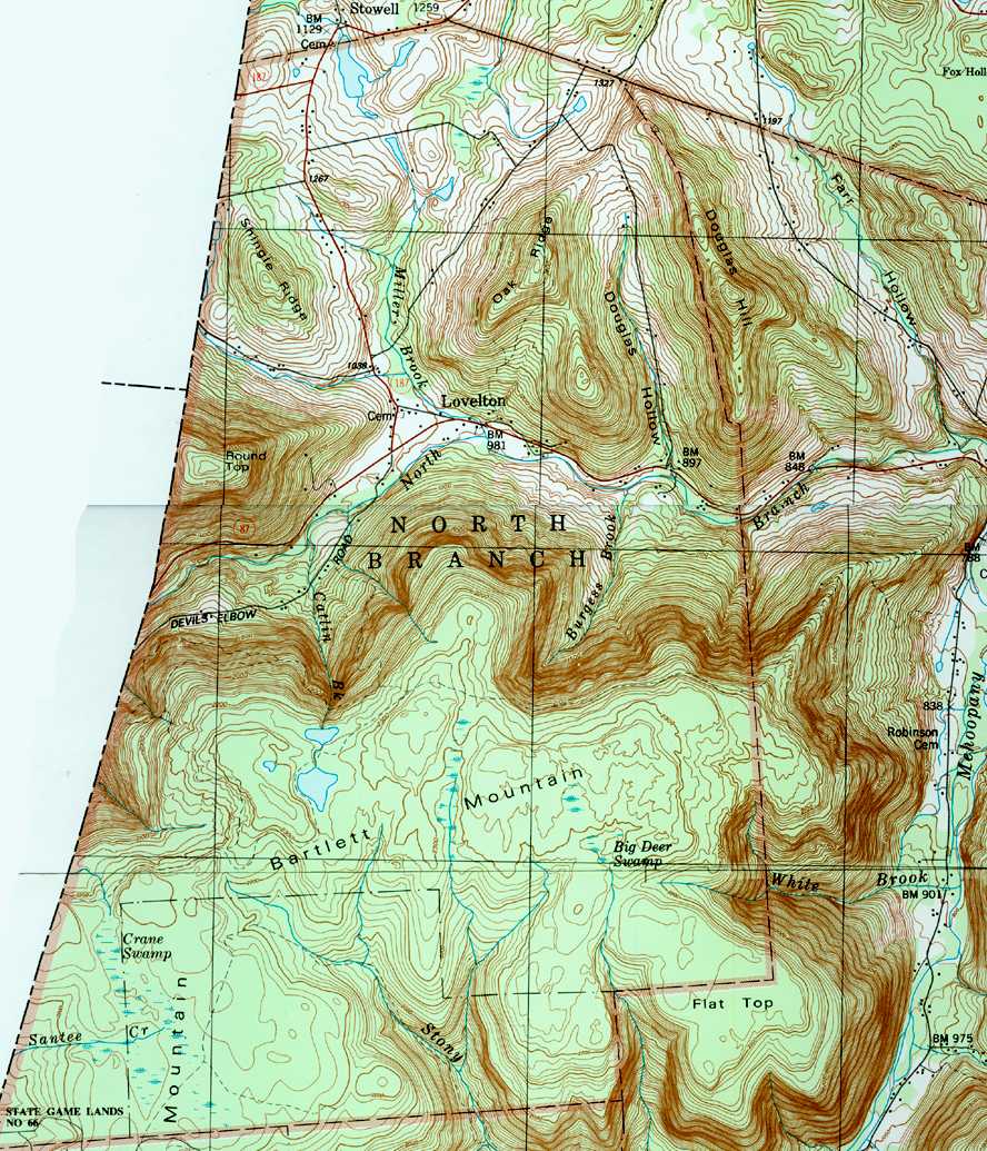
North Branch Mehoopany Creek is a tributary of Mehoopany Creek in Bradford County, Sullivan County, and Wyoming County, in Pennsylvania, in the United States. It is approximately 14 miles (23 km) long and flows through Wilmot Township in Bradford County, Colley Township in Sullivan County, and North Branch Township and Forkston Township. The watershed of the creek has an area of 40.0 square miles (104 km2). The creek has eight named direct tributaries, including hollows. In the 1940s and 1950s, the average discharge for September was found to be just 6.8 cubic feet per second (0.19 m3/s), but was found to be over 100 cubic feet per second (2.8 m3/s) for July and August.

White Brook is a tributary of Mehoopany Creek in Wyoming County, Pennsylvania, in the United States. It is approximately 1.8 miles (2.9 km) long and flows through North Branch Township and Forkston Township, in Wyoming County, Pennsylvania, in the United States. The stream's watershed has an area of 1.75 square miles (4.5 km2). The stream is classified as a High-Quality Coldwater Fishery. It has a small waterfall and a hiking path is located nearby.
Scouten Brook is a tributary of Mehoopany Creek in Wyoming County, Pennsylvania, in the United States. It is approximately 2.2 miles (3.5 km) long and flows through Forkston Township. The watershed of the stream has an area of 2.66 square miles (6.9 km2). The stream is designated as a High-Quality Coldwater Fishery and has wild trout. It is one of five large brooks to cut through South Mountain.
Kasson Brook is a tributary of Mehoopany Creek in Wyoming County, Pennsylvania, in the United States. It is approximately 2.7 miles (4.3 km) long and flows through Forkston Township. The watershed of the stream has an area of 4.53 square miles (11.7 km2). The stream is not designated as an impaired waterbody and is classified as a High-Quality Coldwater Fishery. It is one of several streams to cut through South Mountain.
Henry Lott Brook is a tributary of Mehoopany Creek in Wyoming County, Pennsylvania, in the United States. It is approximately 2.4 miles (3.9 km) long and flows through Forkston Township. The watershed of the stream has an area of 2.68 square miles (6.9 km2). The stream is not designated as an impaired waterbody and it is classified as a High-Quality Coldwater Fishery. It is one of five large tributaries of Mehoopany Creek to cut through the Mehoopany Creek-Bowman Creek watershed divide.
Somer Brook is a tributary of Mehoopany Creek in Wyoming County, Pennsylvania, in the United States. It is approximately 3.7 miles (6.0 km) long and flows through Noxen Township and Forkston Township. The watershed of the stream has an area of 4.48 square miles (11.6 km2). The stream is not designated as an impaired waterbody and is classified as a High-Quality Coldwater Fishery. Fauna that have been observed in the stream's vicinity include northern water shrews and trout.
Wolf Run is a tributary of North Branch Mehoopany Creek in Bradford County and Sullivan County, in Pennsylvania, in the United States. It is approximately 3.2 miles (5.1 km) long and flows through Wilmot Township in Bradford County and Colley Township in Sullivan County. The stream's watershed has an area of 3.45 square miles (8.9 km2), most of which is agricultural land and woodlots. In a 2001 study, seven species of fish were found in Wolf Run, but no gamefish. More recently, wild trout have been observed as well.
Farr Hollow is a tributary of North Branch Mehoopany Creek in Wyoming County, Pennsylvania, in the United States. It is approximately 3.1 miles (5.0 km) long and flows through Windham Township and North Branch Township. The watershed of the stream has an area of 2.99 square miles (7.7 km2). The stream is not designated as an impaired waterbody and flows through a mixture of forested and agricultural land. Eleven different fish species have been observed in the stream, including brook trout.
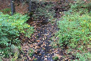
Burgess Brook is a tributary of North Branch Mehoopany Creek in Wyoming County, Pennsylvania, in the United States. It is approximately 1.2 miles (1.9 km) long and flows through North Branch Township. The watershed of the stream has an area of 1.42 square miles (3.7 km2). The stream is narrow, with a high gradient, and is located in a remote area, mostly far away from any roads. It is designated as Class A Wild Trout Waters and has a large population of brook trout, as well as smaller numbers of brown trout. Three other fish species are also present in the stream.
Miller Brook is a tributary of North Branch Mehoopany Creek in Wyoming County, Pennsylvania, in the United States. It is approximately 2.2 miles (3.5 km) long and flows through North Branch Township. The watershed of the stream has an area of 3.86 square miles (10.0 km2). The stream is not designated as an impaired waterbody. Wild trout naturally reproduce in the stream, and several other fish species have been observed.
Catlin Brook is a tributary of North Branch Mehoopany Creek in Wyoming County, Pennsylvania, in the United States. It is approximately 1.5 miles (2.4 km) long and flows through North Branch Township. The watershed of the stream has an area of 1.16 square miles (3.0 km2). The stream itself is very small and steep, and is known for its extremely inaccessible waterfalls.
Sciota Brook is a tributary of North Branch Mehoopany Creek in Bradford County, Sullivan County, and Wyoming County, in Pennsylvania, in the United States. It is approximately 2.0 miles (3.2 km) long and flows through Wilmot Township in Bradford County, Colley Township in Sullivan County, and North Branch Township in Wyoming County. The watershed of the stream has an area of 3.23 square miles (8.4 km2). The stream itself is a moderate-gradient stream in an area consisting primarily of agricultural land and woodlots.
Barnes Brook is a tributary of North Branch Mehoopany Creek in Wyoming County and Sullivan County, in Pennsylvania, in the United States. It is approximately 1.8 miles (2.9 km) long and flows through North Branch Township in Wyoming County and Colley Township in Sullivan County. The watershed of the stream has an area of 1.98 square miles (5.1 km2). It is a high-gradient stream that flows mainly through forested lands, and has one named tributary.
Smith Cabin Run is a tributary of North Branch Mehoopany Creek in Sullivan County, Pennsylvania, in the United States. It is approximately 1.6 miles (2.6 km) long and flows through Colley Township. The watershed of the stream has an area of 1.45 square miles (3.8 km2). The stream has a high gradient and flows primarily through forested land. It has an unnamed pond at its headwaters and a 20-foot (6.1 m) waterfall on an unnamed tributary.
References
- 1 2 3 United States Geological Survey, The National Map Viewer , retrieved January 5, 2018
- ↑ United States Geological Survey (1987), northbra.jpg , retrieved January 5, 2018
- 1 2 3 4 Pennsylvania Gazetteer of Streams (PDF), November 2, 2001, pp. 2, 10, retrieved January 5, 2018
- ↑ United States Environmental Protection Agency, 2006 Waterbody Report for Douglas Hollow , retrieved January 5, 2018
- 1 2 3 4 5 6 Robert Wnuk, Robert Moase, Matthew Gearhart (November 2001), North Branch Mehoopany Creek Basin (404G) Fisheries Management Report (PDF), pp. 1–2, 11, 16–17, 19, 23, retrieved January 5, 2018
{{citation}}: CS1 maint: multiple names: authors list (link) - 1 2 3 Geographic Names Information System, Feature Detail Report for: Douglas Hollow , retrieved January 5, 2018
- ↑ Pennsylvania Fish and Boat Commission (October 2017), Pennsylvania Wild Trout Waters (Natural Reproduction) - October 2017 (PDF), p. 100, archived from the original (PDF) on February 13, 2017, retrieved January 5, 2018
- ↑ Pennsylvania Environmental Council, Wyoming County Office of Community Planning, Mehoopany Creek Watershed Association (March 31, 2007), MEHOOPANY CREEK and LITTLE MEHOOPANY CREEK WATERSHEDS RIVERS CONSERVATION PLAN (PDF), pp. 18, 57, archived from the original (PDF) on April 1, 2019, retrieved January 5, 2018
{{citation}}: CS1 maint: multiple names: authors list (link)