
Koulikoro Region is a region in western Mali. It is the second administrative area of Mali and covers an area of 90,120 km2. Its capital is the city of Koulikoro.
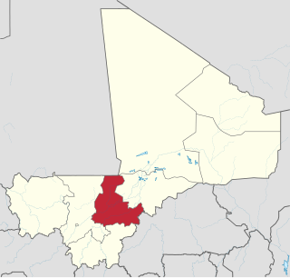
Ségou Region is an administrative region in Mali, situated in the centre of the country with an area of 64,821 km2. The region is bordered by Sikasso Region on the south, Tombouctou and Mopti on the east, Burkina Faso to the southeast and the Koulikoro Region to the west. In 2009 it had 2,336,255 inhabitants, making it the second most populous region of Mali. Its administrative capital is the town of Ségou.
San is an urban commune, town and capital of the Cercle of San in the Ségou Region of Mali. The town lies 10 km south of the Bani River. In the 2009 census the commune had a population of 68,078.
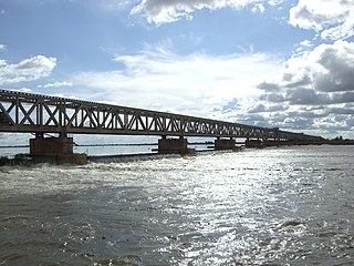
Markala is a commune in Mali's Ségou Region on the Niger River 35 km down stream from the town of Ségou. The commune contains 30 villages in an area of 318 square kilometers and in 2009 had a population of 45,961. Mali's primary irrigation dam, the Markala dam, lies in the commune. The main village of the commune, Diamarabougou, is on the right bank adjacent to the dam which also serves as an important road bridge.
Sokolo is a small town and rural commune in the Cercle of Niona in the Ségou Region of southern-central Mali. The commune has an area of approximately 2,219 square kilometers and includes the town and 17 villages. In the 2009 census the population was 23,338. The town lies 56 km north of Niono.

Bla Cercle is an administrative subdivision of the Ségou Region of Mali. The administrative center (chef-lieu) is the town of Bla.

Barouéli Cercle is an administrative subdivision of the Ségou Region of Mali. The administrative center (chef-lieu) is the town of Barouéli.

Macina Cercle is an administrative subdivision of the Ségou Region of Mali. The administrative center (chef-lieu) is the town of Macina.

Niono Cercle is an administrative subdivision of the Ségou Region of Mali. The administrative center (chef-lieu) is the town of Niono.
Ségou Cercle is an administrative subdivision of the Ségou Region of Mali. The administrative center (chef-lieu) is the town of Ségou.

Tominian Cercle is an administrative subdivision of the Ségou Region of Mali. The administrative center of the local government is in the town of Tominian. The Cercle is divided into Communes, and below this, quarters/villages. In the 2009 census the cercle had a population of 219,853 people.
Dioro is a town and rural commune in the Cercle of Ségou in the Ségou Region of southern-central Mali. The commune extends over an area of approximately 586 square kilometers on the right bank of the Niger River and includes the town and 29 of the surrounding villages. In the 2009 census the commune had a population of 47,876. The town of Dioro is located 57 km northeast of Ségou on the bank of the river.
Pelengana is a small town and rural commune in the Cercle of Ségou in the Ségou Region of southern-central Mali. The commune contains the town and 25 villages in an area of approximately 359 square kilometers. In the 2009 census it had a population of 56,259. The town of Pelengana lies 5 km southeast of Ségou on the Route Nationale 6.
Farako is a small town and rural commune in the Cercle of Ségou in the Ségou Region of southern-central Mali. The commune lies on the north bank of the Niger River and contains 11 settlements in an area of 200 square kilometers. In the 2009 census it had a population of 17,570. The town of Farako is the chef-lieu of the commune.
Saminé is a small town and rural commune in the Cercle of Ségou in the Ségou Region of southern-central Mali. The commune includes the town and 5 villages in an area of approximately 197 square kilometers. In the 2009 census it had a population of 12,082. The Bani River runs along the southern boundary of the commune. The town of Saminé, the chef-lieu of the commune, is 41 km south-southeast of Ségou.
Dougabougou is a small town and rural commune in the Cercle of Ségou in the Ségou Region of southern-central Mali. The commune covers an area of approximately 180 square kilometers and includes the town and 6 villages. In the 2009 census the population was 29,208. The town lies 20 km north of the Markala dam. Many of the inhabitants are employed in the production of sugar on land irrigated by the Office du Niger scheme. A Chinese-Malian company produces sugar in the town.

Macina is a small town and rural commune in the Cercle of Macina in the Ségou Region of southern-central Mali. The commune covers an area of 1,100 square kilometers and contains the main town and 20 villages. In the 2009 census the commune had a population of 36,170.
Siribala is a town and rural commune in the Cercle of Niona in the Ségou Region of southern-central Mali. The commune has an area of approximately 445 square kilometers and includes the town and 18 villages. In the 2009 census it had a population of 37,065. The town lies 25 km south of Niono on the east side of the Fala de Molodo channel that forms part of the Office du Niger irrigation scheme. The present town, actually Siribala Coura, was established in the 1970s to accommodate agricultural workers employed on the sugar-cane plantation and the associated mill. The earlier settlement, Siribala Coro, is 5 km away from the present town.
N'Koumandougou is a rural commune in the Cercle of Ségou in the Ségou Region of Mali. The commune contains 15 villages in an area of approximately 2,040 square kilometers. In the 2009 census it had a population of 14,237. The chef-lieu is the village of Doura.
Kassorola is a commune in the Cercle of San in the Ségou Region of Mali. The administrative center is the town of Nianasso. In a 2009 census, this regions total population was 16,275.

