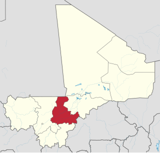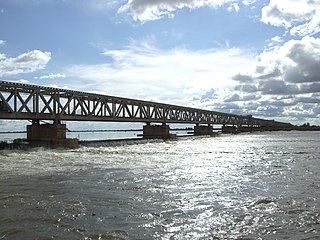
Markala is a commune in Mali's Ségou Region on the Niger River 35 km down stream from the town of Ségou. The commune contains 30 villages in an area of 318 square kilometers and in 2009 had a population of 45,961. Mali's primary irrigation dam, the Markala dam, lies in the commune. The main village of the commune, Diamarabougou, is on the right bank adjacent to the dam which also serves as an important road bridge.

Pelengana is a small town and rural commune in the Cercle of Ségou in the Ségou Region of southern-central Mali. The commune contains the town and 25 villages in an area of approximately 359 square kilometers. In the 2009 census it had a population of 56,259. The town of Pelengana lies 5 km southeast of Ségou on the Route Nationale 6.
Diouna is a village and rural commune in the Cercle of Ségou in the Ségou Region of southern-central Mali. The commune includes 11 villages in an area of approximately 175 square kilometers. In the 2009 census it had a population of 9,244. The chef-lieu of the commune is the village of Diouna which lies 49 km east of Ségou.
Sama Foulala is a village and rural commune in the Cercle of Ségou in the Ségou Region of southern-central Mali. The commune contains 7 villages in an area of approximately 154 square kilometers. In the 2009 census it had a population of 6,180. The village of Sama Foulala, is on the left (north) bank of the River Niger.
Souba is a village and rural commune in the Cercle of Ségou in the Ségou Region of southern-central Mali. The commune contains 24 villages in an area of approximately 1,104 square kilometers. In the 2009 census it had a population of 17,961. The village of Souba, the chef-lieu of the commune, sits on the left (north) bank of the Niger River.
Cinzana is a village and rural commune in the Cercle of Ségou in the Ségou Region of southern-central Mali. The commune includes 71 villages in an area of approximately 1,050 square kilometers. In the 2009 census it had a population of 36,440. The Bani River runs along the southern boundary of the commune. The village of Cinzana lies 41 km southeast of Ségou.
Saminé is a small town and rural commune in the Cercle of Ségou in the Ségou Region of southern-central Mali. The commune includes the town and 5 villages in an area of approximately 197 square kilometers. In the 2009 census it had a population of 12,082. The Bani River runs along the southern boundary of the commune. The town of Saminé, the chef-lieu of the commune, is 41 km south-southeast of Ségou.
Katiéna is a village and rural commune in the Cercle of Ségou in the Ségou Region of southern-central Mali. The commune includes 27 villages in an area of approximately 998 square kilometers. In the 2009 census it had a population of 33,180. The Bani River runs along the southern boundary of the commune. The village of Katiéna is the (chef-lieu) of the commune.
Dougabougou is a small town and rural commune in the Cercle of Ségou in the Ségou Region of southern-central Mali. The commune covers an area of approximately 180 square kilometers and includes the town and 6 villages. In the 2009 census the population was 29,208. The town lies 20 km north of the Markala dam. Many of the inhabitants are employed in the production of sugar on land irrigated by the Office du Niger scheme. A Chinese-Malian company produces sugar in the town.
Togou is a village and rural commune in the Cercle of Ségou in the Ségou Region of southern-central Mali. The commune contains 10 villages in an area of approximate 147 square kilometers. In the 2009 census it had a population of 8,987. The village of Togou, the chef-lieu of the commune, is 35 km northeast of Ségou.
Massala is a village and rural commune in the Cercle of Ségou in the Ségou Region of southern-central Mali. The commune includes 8 villages in an area of approximately 89 square kilometers. In the 2009 census it had a population of 6,547.
Diganibougou or Diganidougou is a rural commune in the Cercle of Ségou in the Ségou Region of Mali. The commune lies to the north of the Niger River opposite the urban commune of Ségou and includes 22 villages in an area of approximately 571 square kilometers. In the 2009 census the commune had a population of 13,879. The administrative center (chef-lieu) is the village of Digani.
Fatiné is a rural commune in the Cercle of Ségou in the Ségou Region of Mali. The commune includes 29 villages in an area of approximately 1006 square kilometers. In the 2009 census it had a population of 25,161. The Bani River runs along the southern boundary of the commune. The administrative center (chef-lieu) is the village of Fatiné Marka.
Kamiandougou is a rural commune in the Cercle of Ségou in the Ségou Region of Mali. The commune contains 18 villages in an area of approximately 311 square kilometers. In the 2009 census it had a population of 14313. The administrative center (chef-lieu) is the village of Nonongo which lies 94 km east-northeast of Ségou.
Baguindadougou is a rural commune in the Cercle of Ségou in the Ségou Region of Mali. The commune includes 14 villages in an area of approximately 702 square kilometers. In the 2009 census it had a population was 10,371. The administrative center (chef-lieu) is the village of Markanibougou.
N'Koumandougou is a rural commune in the Cercle of Ségou in the Ségou Region of Mali. The commune contains 15 villages in an area of approximately 2,040 square kilometers. In the 2009 census it had a population of 14,237. The chef-lieu is the village of Doura.
Bellen is a rural commune in the Cercle of Ségou in the Ségou Region of Mali. It is the most northerly within the cercle and is sparsely populated with only 9 villages in an area of approximately 3,189 square kilometers. In the 2009 census it had a population of 6,949. The chef-lieu is the village of Sagala which lies 89 km northwest of Ségou.
Sirifila-Boundy is a rural commune in the Cercle of Niono in the Ségou Region of Mali. It covers an area of approximately 159 square kilometers and includes 16 villages. In the 2009 census it had a population of 35,290. The seat of local government is the village of N'Debougou.
Toridaga-Ko is a rural commune in the Cercle of Niono in the Ségou Region of Mali. The commune covers an area of approximately 653 square kilometers and includes 18 villages. In the 2009 census the population was 26,901. The administrative center (chef-lieu) is the village of Bolibana which lies 20 km north of Niono.