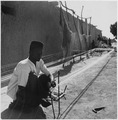
Ségou is a town and an urban commune in south-central Mali that lies 235 kilometres (146 mi) northeast of Bamako on the right bank of the River Niger. The town is the capital of the Ségou Cercle and the Ségou Region. With 130,690 inhabitants in 2009, it is the fifth-largest town in Mali.
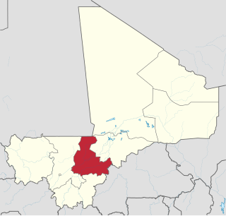
Ségou Region is an administrative region in Mali, situated in the centre of the country with an area of 64,821 km2 (25,028 sq mi), around 5% of Mali. The region is bordered by Sikasso Region on the south, Tombouctou and Mopti on the east, Burkina Faso to the southeast and the Koulikoro Region to the west. In 2009 it had 2,336,255 inhabitants, making it the second most populous region of Mali. Its administrative capital is the town of Ségou.
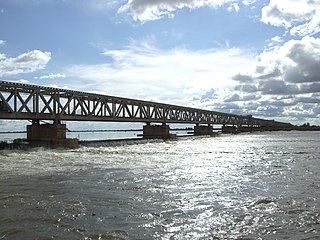
Markala is a commune in Mali's Ségou Region on the Niger River 35 km down stream from the town of Ségou. The commune contains 30 villages in an area of 318 square kilometers and in 2009 had a population of 45,961. Mali's primary irrigation dam, the Markala dam, lies in the commune. The main village of the commune, Diamarabougou, is on the right bank adjacent to the dam which also serves as an important road bridge.
Sokolo is a small town and rural commune in the Cercle of Niona in the Ségou Region of southern-central Mali. The commune has an area of approximately 2,219 square kilometers and includes the town and 17 villages. In the 2009 census the population was 23,338. The town lies 56 km north of Niono.

Niono Cercle is an administrative subdivision of the Ségou Region of Mali. The administrative center (chef-lieu) is the town of Niono.
Sansanding is a small town and rural commune in the Cercle of Ségou in the Ségou Region of southern-central Mali. The commune includes the town and 17 of the surrounding villages in an area of 315 square kilometers. In the 2009 census it had a population of 23,109. The town sits on the left (north) bank of the River Niger about 50 km downstream from Ségou.
Dougabougou is a small town and rural commune in the Cercle of Ségou in the Ségou Region of southern-central Mali. The commune covers an area of approximately 180 square kilometers and includes the town and 6 villages. In the 2009 census the population was 29,208. The town lies 20 km north of the Markala dam. Many of the inhabitants are employed in the production of sugar on land irrigated by the Office du Niger scheme. A Chinese-Malian company produces sugar in the town.

Macina is a small town and rural commune in the Cercle of Macina in the Ségou Region of southern-central Mali. The commune covers an area of 1,100 square kilometers and contains the main town and 20 villages. In the 2009 census the commune had a population of 36,170.
Kolongo or Kolongo Tomo is a village and rural commune in the Cercle of Macina in the Ségou Region of southern-central Mali. The commune covers an area of approximately 484 square kilometers and includes 37 villages. In the 2009 census the commune had a population of 37,648. The village lies on the Fala de Boky-Wéré, an ancient branch of the Niger River that now forms part of the irrigation system of the Office du Niger.

Kokry is a village and rural commune in the Cercle of Macina in the Ségou Region of southern-central Mali. The commune covers an area of approximately 160 square kilometers and includes 17 villages. The farmland is irrigated by the Office du Niger irrigation scheme. The main crop is rice. In the 2009 census the commune had a population of 13,393. The main village, (chef-lieu), is called Kokry Centre to distinguish it from Kokry Bozo which lies 3 km to the east on a strip of land between the Niger River and the Distributeur Kokry, an irrigation canal.
Dogofry is a village and a rural commune in the Cercle of Niona in the Ségou Region of southern-central Mali. The commune covers an area of approximately 3,820 square kilometers and is bordered to the north by the Republic of Mauritania, to the east by the commune of Nampalari, to the southeast by the commune of Diabaly, to the southwest by the commune of Sokolo and to the west by the commune of Guiré in the Cercle of Nara. It includes 19 villages, and had a population of 34,057 in the 2009 census. The south of the commune includes a region irrigated as part of the Office du Niger scheme. The village of Dogofry lies in this irrigated area, about 60 km north of Niono, to the west of the Fala de Molodo and the Distributeur de Kogoni.
Siribala is a town and rural commune in the Cercle of Niona in the Ségou Region of southern-central Mali. The commune has an area of approximately 445 square kilometers and includes the town and 18 villages. In the 2009 census it had a population of 37,065. The town lies 25 km south of Niono on the east side of the Fala de Molodo channel that forms part of the Office du Niger irrigation scheme. The present town, actually Siribala Coura, was established in the 1970s to accommodate agricultural workers employed on the sugar-cane plantation and the associated mill. The earlier settlement, Siribala Coro, is 5 km away from the present town.
Diabaly is a small town and rural commune in the Cercle of Niono in the Ségou Region of Mali. The commune has an area of approximately 1,538 square kilometres (594 sq mi) and includes 28 villages as well as the town. In the 2009 census the commune had a population of 35,266. The town lies 50 kilometres (31 mi) north of Niono on the west side of the Fala de Molodo channel that forms part of the Office du Niger irrigation scheme. The fields around the town are irrigated but much of the commune lies to the east of the Fala de Molodo in an area that lacks irrigation.
Yeredon Saniona is a commune in the Cercle of Niono in the Ségou Region of Mali. The commune covers an area of approximately 307 square kilometers and includes 15 villages. In the 2009 census it had a population of 17,291. The center of local government (chef-lieu) is the village of Werekela.
Sirifila-Boundy is a rural commune in the Cercle of Niono in the Ségou Region of Mali. It covers an area of approximately 159 square kilometers and includes 16 villages. In the 2009 census it had a population of 35,290. The seat of local government is the village of N'Debougou.
Toridaga-Ko is a rural commune in the Cercle of Niono in the Ségou Region of Mali. The commune covers an area of approximately 653 square kilometers and includes 18 villages. In the 2009 census the population was 26,901. The administrative center (chef-lieu) is the village of Bolibana which lies 20 km north of Niono.
Molodo is a village and seat of the commune of Kala Siguida in the Cercle of Niono in the Ségou Region of southern-central Mali. The village was created in 1945 to accommodate labourers working for the Office du Niger irrigation scheme. It lies only 4 km from Niono on opposite side of the Fala de Molodo.
Bolibana is a village and seat of the commune of Toridaga-Ko in the Cercle of Niono in the Ségou Region of southern-central Mali. The village is 20 km north of Niono.
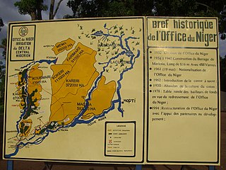
The Office du Niger is a semi-autonomous government agency in Mali that administers a large irrigation scheme in the Ségou Region of the country. Water from the Niger River is diverted into a system of canals at the Markala dam 35 kilometres (22 mi) downstream of Ségou. The water is used to irrigate nearly 100,000 hectares (390 sq mi) of the flat alluvial plains to the north and northeast of Markala that form part of the Delta mort. Although the French colonial administration constructed the system to produce cotton for the textile industry, the main agricultural product is now rice. Around 320,000 tons are grown each year representing 40 percent of the total Malian production. Large quantities of sugar cane are also grown in joint ventures between a Chinese company and the Malian state. The irrigation scheme uses 2.7 km3 (0.65 cu mi) of water each year corresponding to around 10 percent of the total flow of the Niger River.
Alatona is a locality in the Cercle of Niono in the Ségou Region of southern-central Mali. It encompasses the zone covered by the Alatona Irrigation Project, a part of the Office du Niger scheme. Alatona was originally a small village that was abandoned after droughts in the early seventies forced its inhabitants to move closer to the waters of the Fala de Molodo. The population of the former village was 127 in 2007 before the irrigation projects works started, and its old site turned into farmland. The original village was located in the Dogofry commune and is still listed as such by the Malian government, Although the Alatona Irrigation Project extends to the neighboring commune of Diabaly.