Djeguena

Last updated
Djeguena
Commune and town
CountryFlag of Mali.svg  Mali
Region Ségou Region
Cercle San Cercle
Population (1998)
  Total 5,162
Time zone GMT (UTC+0)

Djeguena is a small town and commune in the Cercle of San in the Ségou Region of Mali. In 1998 the commune had a population of 5,162. [1]

Communes of Mali

A Commune is the third level administrative unit in Mali. Mali is divided into eight regions and one capital district (Bamako). These subdivisions bear the name of their principal city. The regions are divided into 49 Cercles. The Cercles and the district are divided into 703 Communes, with 36 Urban Communes and 667 Rural Communes, while some larger Cercles still contain Arrondissements above the Commune level, these are organisational areas with no independent power or office. Rural Communes are subdivided in Villages, while Urban Communes are subdivided into Quartier. Communes usually bear the name of their principal town. The capital, Bamako, consists of six Urban Communes. There were initially 701 communes until the Law No. 01-043 of 7 June 2001 created two new Rural Communes in the desert region in the north east of the country: Alata, Ménaka Cercle in the Gao Region and Intadjedite, Tin-Essako Cercle in the Kidal Region.

San Cercle Cercle in Ségou Region, Mali

San Cercle is an administrative subdivision of the Ségou Region of Mali. The administrative center (chef-lieu) is the town of San.

Ségou Region Region in Mali

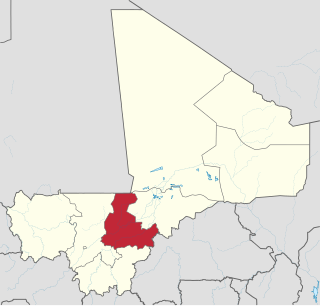
Ségou Region is an administrative region in Mali, situated in the centre of the country with an area of 64,821 km2. The region is bordered by Sikasso Region on the south, Tombouctou and Mopti on the east, Burkina Faso to the southeast and the Koulikoro Region to the west. In 2009 it had 2,336,255 inhabitants, making it the second most populous region of Mali. Its administrative capital is the town of Ségou.

Related Research Articles

Bafoulabé Cercle Cercle in Kayes Region, Mali

Bafoulabé Cercle is an administrative subdivision of the Kayes Region of Mali. The administrative center (chef-lieu) is the town of Bafoulabé. In the 2009 census the population of the cercle was 233,926.

Diéma Cercle Cercle in Kayes Region, Mali

Diéma Cercle is an administrative subdivision of the Kayes Region of Mali. Its administrative center (chef-lieu) is the small town of Diéma. The Cercle is divided into one urban commune and fourteen rural communes. In the 2009 census the cercle had a population of 212,062.

Kita Cercle Cercle in Kayes Region, Mali

Kita Cercle is an administrative subdivision of the Kayes Region of Mali. The administrative centre (chef-lieu) is the town of Kita. In the 2009 census the population of the cercle was 434,379.

Banamba Cercle Cercle in Koulikoro Region, Mali

Banamba Cercle is an administrative subdivision of the Koulikoro Region of Mali. Its seat is the town of Banamba, which is also its largest settlement. It lies at the center east of the region.

Badia, Mali Commune and town in Kayes Region, Mali

Badia is a rural commune in the Cercle of Kita in the Kayes Region of south-western Mali. The principal village is Daféla. In the 2009 census the commune had a population of 7,514.

Kadiolo Cercle Cercle in Sikasso Region, Mali

Kadiolo Cercle is an administrative subdivision of the Sikasso Region of southern Mali. The administrative center (chef-lieu) is the town of Kadiolo.

Sikasso Cercle Cercle in Sikasso Region, Mali

Sikasso Cercle is one of seven administrative subdivision of the Sikasso Region of southern Mali. The capital is the town of Sikasso.

Barouéli Cercle Cercle in Ségou Region, Mali

Barouéli Cercle is an administrative subdivision of the Ségou Region of Mali. The administrative center (chef-lieu) is the town of Barouéli.

Macina Cercle Cercle in Ségou Region, Mali

Macina Cercle is an administrative subdivision of the Ségou Region of Mali. The administrative center (chef-lieu) is the town of Macina.

Tominian Cercle Cercle in Ségou Region, Mali

Tominian Cercle is an administrative subdivision of the Ségou Region of Mali. The administrative center of the local government is in the town of Tominian. The Cercle is divided into Communes, and below this, quarters/villages. In the 2009 census the cercle had a population of 219,853 people.

Kazangasso is a small town and commune in the Cercle of Bla in the Ségou Region of southern-central Mali. As of 1998 the commune had a population of 5,481.

N'Goa is a small town and commune in the Cercle of San in the Ségou Region of Mali. As of 1998 the commune had a population of 7,172.

Sy is a small town and commune in the Cercle of San in the Ségou Region of Mali. In 1998 the commune had a population of 8,888.

Ouolon is a small town and commune in the Cercle of San in the Ségou Region of Mali. In 1998 the commune had a population of 9,278.

Sourountouna is a small town and commune in the Cercle of San in the Ségou Region of Mali. As of 1998 the commune had a population of 11,107.

Niamana is a small town and commune in the Cercle of San in the Ségou Region of Mali. In 1998 the commune had a population of 5,361.

Siadougou is a commune in the Cercle of San in the Ségou Region of Mali. The principal town lies at Siella. In 1998 the commune had a population of 10,294.

Korodougou is a commune in the Cercle of Bla in the Ségou Region of Mali. The principal town lies at Nampasso. In 1998 the commune had a population of 9,618.

Diallassagou is a small town and commune in the Cercle of Bankass in the Mopti Region of Mali. In 1998 the commune had a population of 18,799.

References

  1. "Previsions de desserte des communes pour la periode de 2001-2005" (PDF). Mali Reforme Telecom. Archived from the original (PDF) on August 29, 2004. Retrieved February 17, 2009.

Coordinates: 13°12′01″N5°07′47″W / 13.20028°N 5.12972°W / 13.20028; -5.12972

Geographic coordinate system Coordinate system

A geographic coordinate system is a coordinate system that enables every location on Earth to be specified by a set of numbers, letters or symbols. The coordinates are often chosen such that one of the numbers represents a vertical position and two or three of the numbers represent a horizontal position; alternatively, a geographic position may be expressed in a combined three-dimensional Cartesian vector. A common choice of coordinates is latitude, longitude and elevation. To specify a location on a plane requires a map projection.