Yangasso

Last updated
Yangasso
Commune and town
Mali adm location map.svg
Red pog.svg
Yangasso
Location in Mali
Coordinates: 13°4′N5°19′W / 13.067°N 5.317°W / 13.067; -5.317 Coordinates: 13°4′N5°19′W / 13.067°N 5.317°W / 13.067; -5.317
CountryFlag of Mali.svg  Mali
Region Ségou Region
Cercle Bla Cercle
Population (1998)
  Total 14,456
Time zone GMT (UTC+0)

Yangasso is a small town and commune in the Cercle of Bla in the Ségou Region of southern-central Mali. As of 1998 the commune had a population of 14,456. [1]

Communes of Mali

A Commune is the third level administrative unit in Mali. Mali is divided into eight regions and one capital district (Bamako). These subdivisions bear the name of their principal city. The regions are divided into 49 Cercles. The Cercles and the district are divided into 703 Communes, with 36 Urban Communes and 667 Rural Communes, while some larger Cercles still contain Arrondissements above the Commune level, these are organisational areas with no independent power or office. Rural Communes are subdivided in Villages, while Urban Communes are subdivided into Quartier. Communes usually bear the name of their principal town. The capital, Bamako, consists of six Urban Communes. There were initially 701 communes until the Law No. 01-043 of 7 June 2001 created two new Rural Communes in the desert region in the north east of the country: Alata, Ménaka Cercle in the Gao Region and Intadjedite, Tin-Essako Cercle in the Kidal Region.

Bla Cercle Cercle in Ségou Region, Mali

Bla Cercle is an administrative subdivision of the Ségou Region of Mali. The administrative center (chef-lieu) is the town of Bla.

Ségou Region Region in Mali

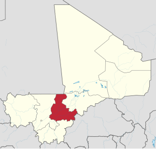
Ségou Region is an administrative region in Mali, situated in the centre of the country with an area of 64,821 km2. The region is bordered by Sikasso Region on the south, Tombouctou and Mopti on the east, Burkina Faso to the southeast and the Koulikoro Region to the west. In 2009 it had 2,336,255 inhabitants, making it the second most populous region of Mali. Its administrative capital is the town of Ségou.

On 21 December 1915 column of Senegalese Tirailleurs of the French Army was defeated here in a battle of the Volta-Bani War. [2]

Senegalese Tirailleurs colonial infantry in the French Army

The Senegalese Tirailleurs were a corps of colonial infantry in the French Army. They were initially recruited from Senegal, French West Africa and subsequently throughout Western, Central and Eastern Africa: the main sub-Saharan regions of the French colonial empire. The noun tirailleur, which translates variously as "skirmisher", "rifleman", or "sharpshooter", was a designation given by the French Army to indigenous infantry recruited in the various colonies and overseas possessions of the French Empire during the 19th and 20th centuries.

French Army land warfare branch of Frances military

The French Army, officially the Ground Army to distinguish it from the French Air Force, Armée de l'Air or Air Army, is the land-based and largest component of the French Armed Forces. It is responsible to the Government of France, along with the other four components of the Armed Forces. The current Chief of Staff of the French Army (CEMAT) is General Jean-Pierre Bosser, a direct subordinate of the Chief of the Defence Staff (CEMA). General Bosser is also responsible, in part, to the Ministry of the Armed Forces for organization, preparation, use of forces, as well as planning and programming, equipment and Army future acquisitions. For active service, Army units are placed under the authority of the Chief of the Defence Staff (CEMA), who is responsible to the President of France for planning for, and use, of forces.

Volta-Bani War

The Volta-Bani War was an anti-colonial rebellion which took place in French West Africa between 1915 and 1917. It was a war between an indigenous African force drawn from a heterogeneous coalition of local peoples who rose against the French Army. At its height in 1916 the rebels mustered from 15,000–20,000 men and fought on several fronts. After about a year and several setbacks, the French army defeated the insurgents and jailed or executed their leaders but resistance continued until 1917.

Related Research Articles

Ségou Cercle Cercle in Ségou Region, Mali

Ségou Cercle is an administrative subdivision of the Ségou Region of Mali. The administrative center (chef-lieu) is the town of Ségou.

Dioro, Mali Commune and town in Ségou Region, Mali

Dioro is a town and rural commune in the Cercle of Ségou in the Ségou Region of southern-central Mali. The commune extends over an area of approximately 586 square kilometers on the right bank of the Niger River and includes the town and 29 of the surrounding villages. In the 2009 census the commune had a population of 47,876. The town of Dioro is located 57 km northeast of Ségou on the bank of the river.

Sébougou Commune and village in Ségou Region, Mali

Sébougou is a village and rural commune in the Cercle of Ségou in the Ségou Region of southern-central Mali. The commune contains 10 villages in an area of approximately 115 square kilometers. In the 2009 census it had a population of 16,175. The commune lies to the south of the River Niger and to the west of the urban commune of Ségou.

Pelengana Commune and town in Ségou Region, Mali

Pelengana is a small town and rural commune in the Cercle of Ségou in the Ségou Region of southern-central Mali. The commune contains the town and 25 villages in an area of approximately 359 square kilometers. In the 2009 census it had a population of 56,259. The town of Pelengana lies 5 km southeast of Ségou on the Route Nationale 6.

Konodimini Commune and village in Ségou Region, Mali

Konodimini is a village and rural commune in the Cercle of Ségou in the Ségou Region of southern-central Mali. The commune includes 23 villages in an area of approximately 362 square kilometers. In the 2009 census it had a population of 16719. The village of Konodimini, the chef-lieu of the commune, lies 23 km southwest of Ségou, on the right (south) bank of the Niger River.

Sakoïba Commune and village in Ségou Region, Mali

Sakoïba is a village and rural commune in the Cercle of Ségou in the Ségou Region of southern-central Mali. The commune contains 23 villages in an area of approximately 360 square kilometers. In the 2009 census it had a population of 18,282. The village of Sakoïba, the chef-lieu of the commune is 16 km south of Ségou.

Diouna Commune and village in Ségou Region, Mali

Diouna is a village and rural commune in the Cercle of Ségou in the Ségou Region of southern-central Mali. The commune includes 11 villages in an area of approximately 175 square kilometers. In the 2009 census it had a population of 9,244. The chef-lieu of the commune is the village of Diouna which lies 49 km east of Ségou.

Boussin Commune and village in Ségou Region, Mali

Boussin is a village and rural commune in the Cercle of Ségou in the Ségou Region of southern-central Mali. The commune includes 15 villages in an area of approximately 178 square kilometers. In the 2009 census it had a population of 12,401. The village of Boussin lies 36 km east of Ségou.

Sama Foulala Commune and village in Ségou Region, Mali

Sama Foulala is a village and rural commune in the Cercle of Ségou in the Ségou Region of southern-central Mali. The commune contains 7 villages in an area of approximately 154 square kilometers. In the 2009 census it had a population of 6,180. The village of Sama Foulala, is on the left (north) bank of the River Niger.

Souba Commune and village in Ségou Region, Mali

Souba is a village and rural commune in the Cercle of Ségou in the Ségou Region of southern-central Mali. The commune contains 24 villages in an area of approximately 1,104 square kilometers. In the 2009 census it had a population of 17,961. The village of Souba, the chef-lieu of the commune, sits on the left (north) bank of the Niger River.

Farako, Ségou Commune and town in Ségou Region, Mali

Farako is a small town and rural commune in the Cercle of Ségou in the Ségou Region of southern-central Mali. The commune lies on the north bank of the Niger River and contains 11 settlements in an area of 200 square kilometers. In the 2009 census it had a population of 17,570. The town of Farako is the chef-lieu of the commune.

Cinzana Commune and village in Ségou Region, Mali

Cinzana is a village and rural commune in the Cercle of Ségou in the Ségou Region of southern-central Mali. The commune includes 71 villages in an area of approximately 1,050 square kilometers. In the 2009 census it had a population of 36,440. The Bani River runs along the southern boundary of the commune. The village of Cinzana lies 41 km southeast of Ségou.

Togou Commune and village in Ségou Region, Mali

Togou is a village and rural commune in the Cercle of Ségou in the Ségou Region of southern-central Mali. The commune contains 10 villages in an area of approximate 147 square kilometers. In the 2009 census it had a population of 8,987. The village of Togou, the chef-lieu of the commune, is 35 km northeast of Ségou.

NGara, Ségou Commune and village in Ségou Region, Mali

N'Gara is a village and rural commune in the Cercle of Ségou in the Ségou Region of southern-central Mali. The commune includes three villages in an area of approximately 159 square kilometers. In the 2009 census it had a population of 11,700. The village of N'Gara, the chef-lieu of the commune, is 30 km southwest of Ségou.

Massala, Mali Commune and village in Ségou Region, Mali

Massala is a village and rural commune in the Cercle of Ségou in the Ségou Region of southern-central Mali. The commune includes 8 villages in an area of approximately 89 square kilometers. In the 2009 census it had a population of 6,547.

Diganibougou Commune in Ségou Region, Mali

Diganibougou or Diganidougou is a rural commune in the Cercle of Ségou in the Ségou Region of Mali. The commune lies to the north of the Niger River opposite the urban commune of Ségou and includes 22 villages in an area of approximately 571 square kilometers. In the 2009 census the commune had a population of 13,879. The administrative center (chef-lieu) is the village of Digani.

Diédougou, Ségou Commune in Ségou Region, Mali

Diédougou is a rural commune in the Cercle of Ségou in the Ségou Region of Mali. The commune includes 21 villages in an area of approximately 409 square kilometers. In the census of 2009 it had a population of 13,268. The main village (chef-lieu) is Yolo which lies 80 km east-northeast of Ségou.

Farakou Massa Commune in Ségou Region, Mali

Farakou Massa is a rural commune in the Cercle of Ségou in the Ségou Region of Mali. The commune lies along the right bank of the River Niger and includes 8 villages in an area of approximately 109 square kilometers. In the 2009 census it had a population of 14,314. The administrative center (chef-lieu) of the commune is the village of Kominé which is 49 km northeast of Ségou.

NKoumandougou Commune in Ségou Region, Mali

N'Koumandougou is a rural commune in the Cercle of Ségou in the Ségou Region of Mali. The commune contains 15 villages in an area of approximately 2,040 square kilometers. In the 2009 census it had a population of 14,237. The chef-lieu is the village of Doura.

Sana, Mali Commune in Ségou Region, Mali

Sana is a rural commune in the Cercle of Macina in the Ségou Region of Mali.The commune covers an area of about 500 square kilometers and includes 27 villages. In the 2009 census the commune had a population of 28,356. The administrative center of the commune is the village of Saye.

References

  1. "Previsions de desserte des communes pour la periode de 2001-2005" (PDF). Mali Reforme Telecom. Retrieved February 17, 2009.
  2. Traoré, Samba Lamine (2011). La saga de la ville historique de Ségou. L'Harmattan. ISBN   978-2296559028.