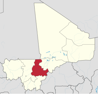
Dioro is a town and rural commune in the Cercle of Ségou in the Ségou Region of southern-central Mali. The commune extends over an area of approximately 586 square kilometers on the right bank of the Niger River and includes the town and 29 of the surrounding villages. In the 2009 census the commune had a population of 47,876. The town of Dioro is located 57 km northeast of Ségou on the bank of the river.
Sébougou is a village and rural commune in the Cercle of Ségou in the Ségou Region of southern-central Mali. The commune contains 10 villages in an area of approximately 115 square kilometers. In the 2009 census it had a population of 16,175. The commune lies to the south of the River Niger and to the west of the urban commune of Ségou.
Pelengana is a small town and rural commune in the Cercle of Ségou in the Ségou Region of southern-central Mali. The commune contains the town and 25 villages in an area of approximately 359 square kilometers. In the 2009 census it had a population of 56,259. The town of Pelengana lies 5 km southeast of Ségou on the Route Nationale 6.
Konodimini is a village and rural commune in the Cercle of Ségou in the Ségou Region of southern-central Mali. The commune includes 23 villages in an area of approximately 362 square kilometers. In the 2009 census it had a population of 16719. The village of Konodimini, the chef-lieu of the commune, lies 23 km southwest of Ségou, on the right (south) bank of the Niger River.
Soignébougou is a village and rural commune in the Cercle of Ségou in the Ségou Region of southern-central Mali. The commune includes 8 villages in an area of approximately 81 square kilometers. In the 2009 census the population was 3,110. The village of Soignébougou, the chef-lieu of the commune, is 30 km southwest of Ségou.
Sakoïba is a village and rural commune in the Cercle of Ségou in the Ségou Region of southern-central Mali. The commune contains 23 villages in an area of approximately 360 square kilometers. In the 2009 census it had a population of 18,282. The village of Sakoïba, the chef-lieu of the commune is 16 km south of Ségou.
Diouna is a village and rural commune in the Cercle of Ségou in the Ségou Region of southern-central Mali. The commune includes 11 villages in an area of approximately 175 square kilometers. In the 2009 census it had a population of 9,244. The chef-lieu of the commune is the village of Diouna which lies 49 km east of Ségou.
Boussin is a village and rural commune in the Cercle of Ségou in the Ségou Region of southern-central Mali. The commune includes 15 villages in an area of approximately 178 square kilometers. In the 2009 census it had a population of 12,401. The village of Boussin lies 36 km east of Ségou.
Sama Foulala is a village and rural commune in the Cercle of Ségou in the Ségou Region of southern-central Mali. The commune contains 7 villages in an area of approximately 154 square kilometers. In the 2009 census it had a population of 6,180. The village of Sama Foulala, is on the left (north) bank of the River Niger.
Souba is a village and rural commune in the Cercle of Ségou in the Ségou Region of southern-central Mali. The commune contains 24 villages in an area of approximately 1,104 square kilometers. In the 2009 census it had a population of 17,961. The village of Souba, the chef-lieu of the commune, sits on the left (north) bank of the Niger River.
Cinzana is a village and rural commune in the Cercle of Ségou in the Ségou Region of southern-central Mali. The commune includes 71 villages in an area of approximately 1,050 square kilometers. In the 2009 census it had a population of 36,440. The Bani River runs along the southern boundary of the commune. The village of Cinzana lies 41 km southeast of Ségou.
Togou is a village and rural commune in the Cercle of Ségou in the Ségou Region of southern-central Mali. The commune contains 10 villages in an area of approximate 147 square kilometers. In the 2009 census it had a population of 8,987. The village of Togou, the chef-lieu of the commune, is 35 km northeast of Ségou.
N'Gara is a village and rural commune in the Cercle of Ségou in the Ségou Region of southern-central Mali. The commune includes three villages in an area of approximately 159 square kilometers. In the 2009 census it had a population of 11,700. The village of N'Gara, the chef-lieu of the commune, is 30 km southwest of Ségou.
Massala is a village and rural commune in the Cercle of Ségou in the Ségou Region of southern-central Mali. The commune includes 8 villages in an area of approximately 89 square kilometers. In the 2009 census it had a population of 6,547.
Kolongo or Kolongo Tomo is a village and rural commune in the Cercle of Macina in the Ségou Region of southern-central Mali. The commune covers an area of approximately 484 square kilometers and includes 37 villages. In the 2009 census the commune had a population of 37,648. The village lies on the Fala de Boky-Wéré, an ancient branch of the Niger River that now forms part of the irrigation system of the Office du Niger.
Diganibougou or Diganidougou is a rural commune in the Cercle of Ségou in the Ségou Region of Mali. The commune lies to the north of the Niger River opposite the urban commune of Ségou and includes 22 villages in an area of approximately 571 square kilometers. In the 2009 census the commune had a population of 13,879. The administrative center (chef-lieu) is the village of Digani.
Farakou Massa is a rural commune in the Cercle of Ségou in the Ségou Region of Mali. The commune lies along the right bank of the River Niger and includes 8 villages in an area of approximately 109 square kilometers. In the 2009 census it had a population of 14,314. The administrative center (chef-lieu) of the commune is the village of Kominé which is 49 km northeast of Ségou.
N'Koumandougou is a rural commune in the Cercle of Ségou in the Ségou Region of Mali. The commune contains 15 villages in an area of approximately 2,040 square kilometers. In the 2009 census it had a population of 14,237. The chef-lieu is the village of Doura.
Sana is a rural commune in the Cercle of Macina in the Ségou Region of Mali.The commune covers an area of about 500 square kilometers and includes 27 villages. In the 2009 census the commune had a population of 28,356. The administrative center of the commune is the village of Saye.