Based on the Köppen climate classification, Dragons Tail is located in an alpine subarctic climate zone with long, cold, snowy winters, and cool to warm summers.[3] Temperatures can drop below −10°F with wind chill factors below −30°F. Precipitation runoff from the west side of the ridge drains into creeks which empty into Lake McDonald, and the east side drains into the St. Mary River.
Geology
Like other mountains in Glacier National Park, Dragons Tail is composed of sedimentary rock laid down during the Precambrian to Jurassic periods. Formed in shallow seas, this sedimentary rock was initially uplifted beginning 170million years ago when the Lewis Overthrust fault pushed an enormous slab of precambrian rocks 3mi (4.8km) thick, 50 miles (80km) wide and 160 miles (260km) long over younger rock of the cretaceous period.[4]
Gallery
Dragons Tail reflected in Hidden Lake
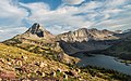
Reynolds Mountain (left) and Dragons Tail (right)
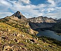
Dragons Tail, Hidden Lake, and Bearhat Mountain (right)
Reynolds Mountain (left) and Dragons Tail (right)
Reynolds Mountain (left) and Dragons Tail (right)
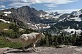
with mountain goat
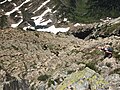
Climbers descend from the ridge of Dragons Tail
Dragons Tail seen from the east, with Fusillade Mountain far left edge, Reynolds Mountain upper right corner, and frozen Saint Mary Lake.
Part of Dragons Tail seen from Bearhat Mountain
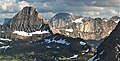
Reynolds Mountain (left), Mt. Jackson (centered), Dragons Tail (right) seen from Mt. Oberlin
This page is based on this Wikipedia article Text is available under the CC BY-SA 4.0 license; additional terms may apply. Images, videos and audio are available under their respective licenses.