Dry Prong, Louisiana

Last updated

Dry Prong, Louisiana
Village
Grant Parish Louisiana Incorporated and Unincorporated areas Dry Prong Highlighted.svg
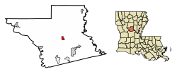
Location of Dry Prong in Grant Parish, Louisiana.
Louisiana in United States (US48).svg
Location of Louisiana in the United States
Coordinates: 31°34′44″N92°31′46″W / 31.57889°N 92.52944°W / 31.57889; -92.52944
CountryUnited States
StateLouisiana
Parish Grant
Area
[1]
  Total1.40 sq mi (3.62 km2)
  Land1.39 sq mi (3.59 km2)
  Water0.01 sq mi (0.03 km2)
Elevation
230 ft (70 m)
Population
 (2020)
  Total455
  Density328.28/sq mi (126.75/km2)
Time zone UTC-6 (CST)
  Summer (DST) UTC-5 (CDT)
Area code 318
FIPS code 22-21765

Dry Prong is a village in central Grant Parish, Louisiana, United States. It is part of the Alexandria, Louisiana Metropolitan Statistical Area. The population was 436 at the 2010 census. [2]

Contents

History

Dry Prong was incorporated as a village in 1945.

According to tradition, the village received its name when a family moved to the region in the 1870s to build a sawmill. To power the mill, they built a water wheel, only to discover that the creek over which they had built it went dry every summer: the creek was a "dry prong". [3] The mill was soon rebuilt over a nearby creek which flowed all year, but the name stuck. The creek is now outside the city limits, on Highway 123. Shane Davis is the current mayor of the village.

Geography

Dry Prong is located at the center of Grant Parish at 31°34′44″N92°31′46″W / 31.57889°N 92.52944°W / 31.57889; -92.52944 (31.578819, -92.529487). [4] U.S. Route 167 passes through the village, leading north 26 miles (42 km) to Winnfield and south 22 miles (35 km) to Alexandria. The village is within Kisatchie National Forest.

According to the United States Census Bureau, the village has a total area of 1.3 square miles (3.4 km2), of which 0.01 square miles (0.02 km2), or 0.65%, is water. [2]

Major highways

Demographics

Historical population
CensusPop.Note
1950 377
1960 360−4.5%
1970 352−2.2%
1980 52649.4%
1990 380−27.8%
2000 42110.8%
2010 4363.6%
2020 4554.4%
U.S. Decennial Census [5]

As of the census [6] of 2000, there were 421 people, 176 households, and 124 families residing in the village. The population density was 315.8 inhabitants per square mile (121.9/km2). There were 195 housing units at an average density of 146.3 per square mile (56.5/km2). The racial makeup of the village was 95.25% White, 0.95% African American, 0.24% Native American, 1.66% from other races, and 1.90% from two or more races. Hispanic or Latino of any race were 2.61% of the population.

There were 176 households, out of which 30.7% had children under the age of 18 living with them, 55.7% were married couples living together, 11.9% had a female householder with no husband present, and 29.5% were non-families. 28.4% of all households were made up of individuals, and 14.8% had someone living alone who was 65 years of age or older. The average household size was 2.39 and the average family size was 2.91.

In the village, the population was spread out, with 25.7% under the age of 18, 5.7% from 18 to 24, 25.7% from 25 to 44, 27.8% from 45 to 64, and 15.2% who were 65 years of age or older. The median age was 40 years. For every 100 females, there were 97.7 males. For every 100 females age 18 and over, there were 94.4 males.

The median income for a household in the village was $32,917, and the median income for a family was $43,214. Males had a median income of $36,944 versus $18,864 for females. The per capita income for the village was $13,978. About 12.9% of families and 19.0% of the population were below the poverty line, including 25.0% of those under age 18 and 13.5% of those age 65 or over.

Education

Dry Prong residents are zoned to Grant Parish School Board schools.

Media

Notable people

Related Research Articles

<span class="mw-page-title-main">LaSalle Parish, Louisiana</span> Parish in Louisiana, United States

LaSalle Parish is a parish located in the U.S. state of Louisiana. As of the 2020 United States Census, the population was 14,791. The parish seat is Jena. The parish was created in 1910 from the western section of Catahoula Parish.

<span class="mw-page-title-main">Hessmer, Louisiana</span> Village in Louisiana, United States

Hessmer is a village in Avoyelles Parish, Louisiana, United States. The population was 802 at the 2010 census.

<span class="mw-page-title-main">Bienville, Louisiana</span> Village in Louisiana, United States

Bienville is a village in Bienville Parish, Louisiana, United States. The population was 218 at the 2010 census.

<span class="mw-page-title-main">Bryceland, Louisiana</span> Village in Louisiana, United States

Bryceland is a village in Bienville Parish, Louisiana, United States. The population was 108 at the 2010 census.

<span class="mw-page-title-main">Clarks, Louisiana</span> Village in Louisiana, United States

Clarks is a rural village in Caldwell Parish, Louisiana, United States. The population was 1,017 at the 2010 census. Clarks is the largest community by population in Caldwell Parish.

<span class="mw-page-title-main">Grayson, Louisiana</span> Village in Louisiana, United States

Grayson is a village in Caldwell Parish, Louisiana, United States. The population was 532 at the 2010 census.

<span class="mw-page-title-main">Pine Prairie, Louisiana</span> Village in Louisiana, United States

Pine Prairie is a village in Evangeline Parish, Louisiana, United States. The population was 1,610 at the 2010 census, up from 1,087 in 2000.

<span class="mw-page-title-main">Turkey Creek, Louisiana</span> Village in Louisiana, United States

Turkey Creek is a village in Evangeline Parish, Louisiana, United States. The population was 441 at the 2010 census, up from 356 in 2000.

<span class="mw-page-title-main">Colfax, Louisiana</span> Town in Louisiana, United States

Colfax is a town in, and the parish seat of, Grant Parish, Louisiana, United States, founded in 1869. Colfax is part of the Alexandria, Louisiana metropolitan area. The largely African American population of Colfax counted 1,558 at the 2010 census.

<span class="mw-page-title-main">Georgetown, Louisiana</span> Village in Louisiana, United States

Georgetown is a village in Grant Parish, Louisiana, United States. It is part of the Alexandria, Louisiana Metropolitan Statistical Area. The population was 327 at the 2010 census.

<span class="mw-page-title-main">Pollock, Louisiana</span> Town in Louisiana, United States

Pollock is a small town in Grant Parish, Louisiana, United States. It is part of the Alexandria, Louisiana Metropolitan Statistical Area. The population was 469 as of the 2010 census, up from 376 in 2000. Pollock and southern Grant Parish have been experiencing residential and business growth in recent years. The population of Pollock increased between the 2000 and 2010 censuses as a result of the annexation of the land surrounding a federal prison, the United States Penitentiary, Pollock.

<span class="mw-page-title-main">Eros, Louisiana</span> Town in Louisiana, United States

Eros is a town in Jackson Parish, Louisiana, United States. The population was 130 at the 2020 Census It is part of the Ruston Micropolitan Statistical Area.

<span class="mw-page-title-main">Hodge, Louisiana</span> Village in Louisiana, United States

Hodge is a village in Jackson Parish, Louisiana, United States. The population was 470 at the 2010 census. It is part of the Ruston Micropolitan Statistical Area.

<span class="mw-page-title-main">North Hodge, Louisiana</span> Village in Louisiana, United States

North Hodge is a village in Jackson Parish, Louisiana, United States. The population was 388 at the 2010 census, down from 436 at the 2000 census. It is part of the Ruston Micropolitan Statistical Area.

<span class="mw-page-title-main">Quitman, Louisiana</span> Village in Louisiana, United States

Quitman is a village in Jackson Parish, Louisiana, United States. As of the 2010 census, the village population was 181. Quitman is 15 miles (24 km) south of Ruston on U.S. Highway 167, and 9 miles (14 km) north of Jonesboro, the parish seat of Jackson Parish. It is also adjacent to the Jackson Bienville Wildlife Area.

<span class="mw-page-title-main">Fenton, Louisiana</span> Village in Louisiana, United States

Fenton is a village in Jefferson Davis Parish, Louisiana, United States. The population was 226 at the 2020 census. It is notable for being a speed trap along U.S. Route 165.

<span class="mw-page-title-main">Spearsville, Louisiana</span> Village in Louisiana, United States

Spearsville is a village in Union Parish, Louisiana, United States. The population was 137 at the 2010 census, a decrease from 155 in 2000. It is part of the Monroe Metropolitan Statistical Area.

<span class="mw-page-title-main">Sikes, Louisiana</span> Village in Louisiana, United States

Sikes is a village in Winn Parish, Louisiana, United States. The population was 121 at the 2000 census.

<span class="mw-page-title-main">Tullos, Louisiana</span> Town in Louisiana, United States

Tullos is a town in LaSalle and Winn parishes in the U.S. state of Louisiana, along Castor Creek. The population was 385 at the 2010 census.

<span class="mw-page-title-main">Downsville, Louisiana</span> Village in Louisiana, United States

Downsville is a village in Lincoln and Union parishes in the U.S. state of Louisiana. The population as of the 2010 census was 143, an increase from 118 in the 2000 census.

References

  1. "2020 U.S. Gazetteer Files". United States Census Bureau. Retrieved March 20, 2022.
  2. 1 2 "Geographic Identifiers: 2010 Demographic Profile Data (G001): Dry Prong village, Louisiana". American Factfinder. U.S. Census Bureau. Retrieved December 15, 2016.[ dead link ]
  3. "Some towns sure have funny names". The Miami News. pp. 4A. Retrieved May 19, 2015.
  4. "US Gazetteer files: 2010, 2000, and 1990". United States Census Bureau. February 12, 2011. Retrieved April 23, 2011.
  5. "Census of Population and Housing". Census.gov. Retrieved June 4, 2015.
  6. "U.S. Census website". United States Census Bureau . Retrieved January 31, 2008.