
A suspension bridge is a type of bridge in which the deck is hung below suspension cables on vertical suspenders. The first modern examples of this type of bridge were built in the early 1800s. Simple suspension bridges, which lack vertical suspenders, have a long history in many mountainous parts of the world.

A cable-stayed bridge has one or more towers, from which cables support the bridge deck. A distinctive feature are the cables or stays, which run directly from the tower to the deck, normally forming a fan-like pattern or a series of parallel lines. This is in contrast to the modern suspension bridge, where the cables supporting the deck are suspended vertically from the main cable, anchored at both ends of the bridge and running between the towers. The cable-stayed bridge is optimal for spans longer than cantilever bridges and shorter than suspension bridges. This is the range within which cantilever bridges would rapidly grow heavier, and suspension bridge cabling would be more costly.
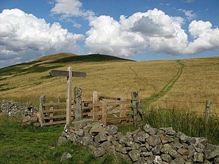
St Cuthbert's Way is a 100-kilometre (62 mi) long-distance trail between the Scottish Borders town of Melrose and Lindisfarne off the coast of Northumberland, England. The walk is named after Cuthbert, a 7th-century saint, a native of the Borders who spent his life in the service of the church. The route links Melrose Abbey, where Cuthbert began his religious life, with his initial burial place on Holy Island. Cuthbert achieved the status of bishop, and was called a saint eleven years after his death, when his coffin was opened and his remains found to be perfectly preserved.
The Union Chain Bridge or Union Bridge is a suspension bridge that spans the River Tweed between Horncliffe, Northumberland, England and Fishwick, Berwickshire, Scotland. It is four miles (6.4 km) upstream of Berwick-upon-Tweed. When it opened in 1820 it was the longest wrought iron suspension bridge in the world with a span of 449 feet (137 m), and the first vehicular bridge of its type in the United Kingdom. Although work started on the Menai Suspension Bridge earlier, the Union Bridge was completed first. The suspension bridge, which is a Category A listed building in Scotland, is now the oldest to be still carrying road traffic.

David Stuart Erskine, 11th Earl of Buchan,, styled Lord Cardross between 1747 and 1767, was a Scottish antiquarian, founder of the Society of Antiquaries of Scotland, and patron of the arts and sciences.

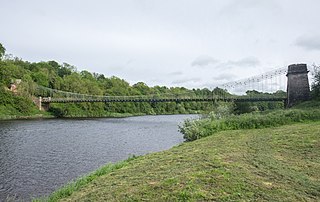
Dryburgh Suspension Bridge is a suspension bridge erected near Dryburgh Abbey, Scottish Borders.

Dryburgh is a village in the Borders region of Scotland, within the county of Berwickshire. It is most famous for the ruined Dryburgh Abbey.
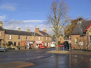
St Boswells is a village on the south side of the River Tweed in the Scottish Borders, about 1 mile southeast of Newtown St Boswells on the A68 road. It lies within the boundaries of the historic county of Roxburghshire.
Greycrook is a village off the A68 and the A699 in the Scottish Borders, approximately 500 m (550 yd) south-east of St Boswells, and close to Dryburgh, Dryburgh Abbey, Maxton, Newtown St Boswells, and the River Tweed.

Captain Sir Samuel Brown of Netherbyres KH FRSE was an early pioneer of chain design and manufacture and of suspension bridge design and construction. He is best known for the Union Bridge of 1820, the first vehicular suspension bridge in Britain.

Angers Bridge, also called the Basse-Chaîne Bridge, was a suspension bridge over the Maine River in Angers, France. It was designed by Joseph Chaley and Bordillon, and built between 1836 and 1839. The bridge collapsed on 16 April 1850, while a battalion of French soldiers were marching across it, killing over 200.

Bemersyde is a hamlet in the Mertoun parish of Berwickshire, in the Scottish Borders. It sits on the left bank of the River Tweed, about three miles east of Melrose. Bemersyde House, the ancestral home of the Haig family, is the most notable feature.

The William Wallace Statue near the grounds of the Bemersyde estate, near Melrose in the Scottish Borders is a statue commemorating William Wallace. It was commissioned by David Steuart Erskine, 11th Earl of Buchan, and it protected as a category B listed building.
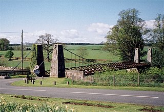
The Kalemouth Suspension Bridge is a suspension bridge at Kalemouth in the Scottish Borders area of Scotland, near the B6401. It crosses the River Teviot just above its confluence with the Kale Water, near Eckford.

Clintmains is a village by the River Tweed, in the parish of Mertoun, to the east of Newtown St Boswells, in the Scottish Borders area of Scotland, in the former county of Berwickshire.

Lady Grisell Baillie was the first woman to be created a deaconess in the Church of Scotland.
Dryburgh Bridge may refer to the following footbridges over the Tweed in Scotland:

The Mertoun Bridge is a bridge across the River Tweed in the Scottish Borders.
Mertoun is a parish in the south-west of the historic county of Berwickshire in the Scottish Borders area of Scotland. Together with the parish of Maxton, Roxburghshire it forms the Maxton and Mertoun Community Council area. It was included in the former Ettrick and Lauderdale District of Borders Region, by the Local Government (Scotland) Act 1973, from 1975 to 1996.

