Mertoun Bridge

Last updated

Mertoun Bridge
Mertoun Bridge - geograph.org.uk - 763034.jpg
Coordinates 55°34′50″N2°37′14″W / 55.5804579°N 2.6206061°W / 55.5804579; -2.6206061 Coordinates: 55°34′50″N2°37′14″W / 55.5804579°N 2.6206061°W / 55.5804579; -2.6206061
Crosses River Tweed
Characteristics
MaterialStone
No. of spans5
History
Designer James Slight
Constructed byWilliam Slight
Construction end1841

The Mertoun Bridge is a bridge across the River Tweed in the Scottish Borders.

Contents

History

The Act of Parliament that authorised the building of a bridge was passed in 1837, and it was designed by James Slight of Edinburgh. [1] Although the original design was for a bridge built entirely of stone, it was eventually built with stone piers and wooden arches, but with sufficiently strong piers and abutments to allow stone arches to be used in the future. [2]

A flood in September 1839 washed away all the wooden parts. [3] It was rebuilt between 1839 and 1841 by William Smith of Montrose, with the piers raised by 2 feet (0.61 m) compared with the original design. [2]

The stone arches were added in 1887. [4] The bridge is a Category B listed building. [5] [6]

Design

The piers built between 1 and 3 feet (0.30 and 0.91 m) into the bedrock, which was achieved by using cofferdams, and the depth of the bottom of the piers is between 6 feet 3 inches (1.91 m) and 11 feet 7 inches (3.53 m) below the summer level of the river. [2] The piers are 18 feet (5.5 m) high from the summer level of the river to the base of the arches, and 29 feet 6 inches (8.99 m) long and 10 feet (3.0 m) deep, with a straight profile. [2] The masonry used is ashlar, and the stone is a reddish sandstone quarried nearby. [7]

The bridge carries the B6404 public road across the River Tweed near St Boswells. [8] At the western end of the bridge is a toll-house, built on the embankment leading to the bridge. [9] Nearby is the Mertoun House Bridge, a suspension footbridge dating from the mid-eighteenth century. [10]

The Tweed is an important fishing river, and the Mertoun Bridge is the middle of the Mertoun Upper beat. [11]

Related Research Articles

Ladykirk and Norham Bridge bridge on the English-Scottish border in the United Kingdom

The Ladykirk and Norham Bridge connects Ladykirk in the Borders, Scotland, with Norham in Northumberland, England, across the River Tweed.

The Kelvin Aqueduct is a navigable aqueduct in Glasgow, Scotland, which carries the Forth and Clyde Canal over the River Kelvin.

Connel Bridge Cantilever bridge that spans Loch Etive in Scotland

Connel Bridge is a cantilever bridge that spans Loch Etive at Connel in Scotland. The bridge takes the A828 road across the narrowest part of the loch, at the Falls of Lora. It is a category B listed structure.

Ballochmyle Viaduct High railway viaduct in Ayrshire, Scotland

The Ballochmyle Viaduct is the highest extant railway viaduct in Britain. It is 169 feet (52 m) high, and carries the railway over the River Ayr near Mauchline and Catrine in East Ayrshire, Scotland. It carries the former Glasgow and South Western Railway line between Glasgow and Carlisle.

Slateford Aqueduct bridge in United Kingdom

The Slateford Aqueduct is a navigable aqueduct that carries the Union Canal over the Water of Leith at Slateford, Edinburgh, Scotland. Completed in 1822, it has eight arches and spans a length of 500 feet (150 m).

Brig o Doon late medieval bridge in Ayrshire, Scotland

The Brig o' Doon, sometimes called the Auld Brig or Old Bridge of Doon, is a late medieval bridge in Ayrshire, Scotland, and a Category A structure.

Avon Aqueduct 12-arch aqueduct carrying the Union Canal over the River Avon between Falkirk and West Lothian, Scotland, UK

The Avon Aqueduct is a navigable aqueduct that carries the Union Canal over the River Avon, near Linlithgow, Scotland.

Leaderfoot Viaduct Railway viaduct over the River Tweed near Melrose in the Scottish Borders.

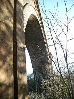
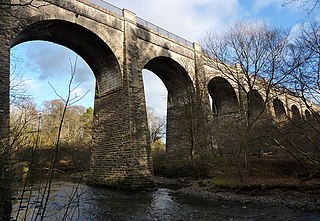
The Leaderfoot Viaduct, also known as the Drygrange Viaduct, is a railway viaduct over the River Tweed near Melrose in the Scottish Borders.

Yair, Scottish Borders

Yair, also known as The Yair, is an estate in the Scottish Borders. It stands by the River Tweed in the former county of Selkirkshire, 2.5 miles (4.0 km) north-west of Selkirk, and 28 miles (45 km) south of Edinburgh. The name comes from the old Scots word for a fish trap. The estate is centred on Yair House, which is protected as a category A listed building. The nearby Yair Bridge is also category A listed.

Tweed Bridge stone-built road bridge over the River Tweed in Peebles, in the Scottish Borders

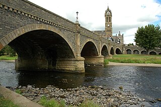
The Tweed Bridge is a stone-built road bridge of five spans over the River Tweed in Peebles, in the Scottish Borders.

Kalemouth Suspension Bridge bridge at Kalemouth in the Scottish Borders area of Scotland

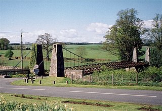
The Kalemouth Suspension Bridge is a suspension bridge at Kalemouth in the Scottish Borders area of Scotland, near the B6401. It crosses the River Teviot just above its confluence with the Kale Water, near Eckford.

Yair Bridge bridge in United Kingdom

The Yair Bridge or Fairnilee Bridge is a bridge across the River Tweed at Yair, near Galashiels in the Scottish Borders.

Glaisnock Viaduct bridge in United Kingdom

The Glaisnock Viaduct or Caponacre Viaduct is a viaduct over the Glaisnock Water, on the former Glasgow and South Western Railway. It is located in Cumnock, East Ayrshire.

Caledonian Railway Bridge bridge in United Kingdom

The Caledonian Railway Bridge is a bridge crossing the River Clyde at Broomielaw in Scotland. It is adjacent to Glasgow Central station.

Newbattle Viaduct railway bridge in Midlothian, Scotland, UK

The Newbattle Viaduct, sometimes also called the Lothianbridge, Newtongrange or Dalhousie Viaduct, carries the Borders Railway, which opened in 2015, over the River South Esk near Newtongrange, Midlothian, Scotland.

Avon Viaduct 23-arch railway viaduct carrying the Edinburgh-Glasgow railway across the River Avon in West Lothian, Scotland, UK

The Avon Viaduct carries the railway over the River Avon at Linlithgow, West Lothian, Scotland.

Broomhill Bridge bridge in Highland, Scotland, UK

The Broomhill Bridge is a wooden bridge over the River Spey.

Drygrange Old Bridge bridge in Scotland

The Drygrange Old Bridge is a disused road bridge over the River Tweed near Melrose in the Scottish Borders.

Kelso Bridge bridge across the River Tweed at Kelso, in the Scottish Borders

The Kelso Bridge or Rennie's Bridge is a bridge across the River Tweed at Kelso, in the Scottish Borders.

Mertoun Human settlement in Scotland

Mertoun is a parish in the south-west of the historic county of Berwickshire in the Scottish Borders area of Scotland. Together with the parish of Maxton, Roxburghshire it forms the Maxton and Mertoun Community Council area. It was included in the former Ettrick and Lauderdale District of Borders Region, by the Local Government (Scotland) Act 1973, from 1975 to 1996.

References

  1. "Mertoun Bridge". rcahms.gov.uk. Retrieved 25 March 2015.
  2. 1 2 3 4 Newlands, James; White, John (1869). The Carpenter and Joiner's Assistant. Blackie. p. 171.
  3. Burke, Edmund (1840). The Annual Register of World Events: A Review of the Year. Longmans, Green. p. 175.
  4. Strang, Charles Alexander (1994). Borders and Berwick: An Illustrated Architectural Guide to the Scottish Borders and Tweed Valley. Rutland Press. ISBN   978-1-873190-10-4.
  5. Historic Environment Scotland. "Mertoun Bridge  (Category B) (LB15113)" . Retrieved 29 March 2019.
  6. Historic Environment Scotland. "Mertoun Bridge  (Category B) (LB17410)" . Retrieved 29 March 2019.
  7. "Mertoun Bridge, Roxburghshire" . scran.ac.uk. Retrieved 5 August 2015.
  8. Google (25 March 2015). "Mertoun Bridge" (Map). Google Maps . Google. Retrieved 25 March 2015.
  9. "Mertoun Bridge, Tollhouse". rcahms.gov.uk. Retrieved 5 August 2015.
  10. "Mertoun House, Bridge". rcahms.gov.uk. Retrieved 5 August 2015.
  11. "Mertoun Upper". fishpal.com. Retrieved 9 August 2015.