
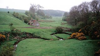
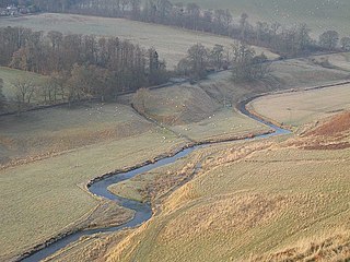
The River Leader, or Leader Water, is a small tributary of the River Tweed in Lauderdale in the Scottish Borders. It flows southwards from the Lammermuir Hills through the towns of Lauder and Earlston, joining the River Tweed at Leaderfoot.
The River Leader, or Leader Water, is a small tributary of the River Tweed in Lauderdale in the Scottish Borders. It flows southwards from the Lammermuir Hills through the towns of Lauder and Earlston, joining the River Tweed at Leaderfoot.
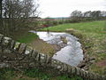
The feeder burns of the Leader Water are the Headshaw Burn, the Hillhouse Burn and the Kelphope Burn. They combine at the Carfrae mill hotel and the village of Oxton. The river is now sandwiched between the A68 and the A697, and it has absorbed the Cleekhimin Burn, Harry Burn, Washing Burn and Earnscleugh Burn. The Leader Water now passes to the east of the town of Lauder, by Thirlestane Castle. The A679 bridges the river which continues past Lauder Barns, West Mains and St. Leonards where the Leader receives his final feeder burn, the Boondreigh Burn. It now sticks closely by the A68, near the Whitslaid Tower, the Blainslies, Galadean, Birkhill, Chapel-on-Leader and Leadervale. After passing through the outskirts of Earlston, the course of the river is almost done, as it skirts some woodland, and after passing Drygrange, it joins the Tweed at Leaderfoot Viaduct.
Nearby are Scott's View, Bemersyde House, Bemersyde Moss, Carolside, Dryburgh Abbey, the William Wallace Statue and the Roman forts at Newstead (Trimontium).


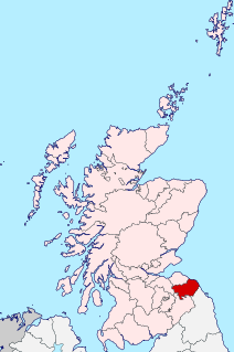
The Scottish Borders is one of 32 council areas of Scotland. It borders the City of Edinburgh, Dumfries and Galloway, East Lothian, Midlothian, South Lanarkshire, West Lothian and, to the south-west, south and east, the English counties of Cumbria and Northumberland. The administrative centre of the area is Newtown St Boswells.

The River Tyne is a river in Scotland. It rises in the Moorfoot Hills in Midlothian near Tynehead to the south of Edinburgh, at the junction of the B6458 and the B6367. It continues approximately 30 miles northeast, and empties into the North Sea near Belhaven.

The A68 is a major road in the United Kingdom, running from Darlington in England to the A720 in Edinburgh.
Berwickshire is a historic county, registration county and lieutenancy area in southeastern Scotland, on the English border. It takes its name from Berwick-upon-Tweed, which was part of the Kingdom of Northumbria at the time of the county's formation, but became part of England in 1482 after several centuries of swapping back and forth between the two kingdoms

The former Royal Burgh of Lauder is a town in the Scottish Borders in the historic county of Berwickshire. On the Southern Upland Way, the burgh lies 27 miles (43 km) southeast of Edinburgh, on the western edge of the Lammermuir Hills.
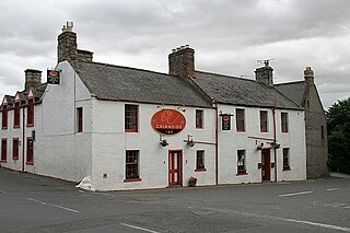
Chirnside is a hillside village in Berwickshire in Scotland, 9 miles (14 km) west of Berwick-upon-Tweed and 7 miles (11 km) east of Duns.

Earlston is a civil parish and market town in the county of Berwickshire, within the Scottish Borders. It is on the River Leader in Lauderdale, Scotland.

Scott's View is a viewpoint in the Scottish Borders, overlooking the valley of the River Tweed, which is reputed to be one of the favourite views of Sir Walter Scott.
Cessford Burn is a small stream which eventually runs to meet the Kale Water and then joins the River Teviot, finally entering the River Tweed at Kelso, Scotland.

Oxton is a small rural village in the Scottish Borders area of Scotland, just off the A68. It is 4+1⁄2 miles north of Lauder, and 20 mi (32 km) southeast of the centre of Edinburgh, yet in a quiet rural position.
The TD postcode area, also known as the Galashiels postcode area, is a group of fifteen postcode districts in south-east Scotland and the far north-east of England, within seventeen post towns. These cover most of the Scottish Borders council area and the northernmost part of Northumberland, plus a part of south-eastern East Lothian and a very small part of Cumbria.
Eden Water is a tributary of the River Tweed in the Scottish Borders of Scotland. "Water" is the Lowland Scots term for a small river.
The Lyne Water is a tributary of the River Tweed which rises in the Pentland Hills of southern Scotland at Baddinsgill Reservoir. It runs through West Linton and Romannobridge, passes Flemington and Lyne Station and enters the Tweed west of Peebles. It floods regularly in winter and occasionally in summer. There is free fishing above Flemington Bridge, and below Flemington fishing in the river is administered by the Peebles fishing authority.
Addinston is a farming village, off the A697, close to the Carfraemill roundabout, with two hill forts and settlements, in Lauderdale in the Scottish Borders area of Scotland, in the former Berwickshire.

Lauderdale is a long narrow geographical district in the Scottish Borders, Scotland, being the valley of the Leader Water,, above which rivulet St. Cuthbert had a vision of St. Aidan's soul being conducted to heaven. It is traversed from end to end by the A68 trunk road which runs from Darlington to Edinburgh.

Eddleston Water is a small river north of Peebles, in the Scottish Borders area of Scotland which joins the River Tweed at Peebles. It is also known locally as "The Cuddy".

Bemersyde is a hamlet in the Mertoun parish of Berwickshire, in the Scottish Borders. It sits on the left bank of the River Tweed, about three miles east of Melrose. Bemersyde House, the ancestral home of the Haig family, is the most notable feature.

The William Wallace Statue near the grounds of the Bemersyde estate, near Melrose in the Scottish Borders is a statue commemorating William Wallace. It was commissioned by David Steuart Erskine, 11th Earl of Buchan, and it protected as a category B listed building.

Clintmains is a village by the River Tweed, in the parish of Mertoun, to the east of Newtown St Boswells, in the Scottish Borders area of Scotland, in the former county of Berwickshire.
| | This section is empty. You can help by adding to it. (July 2010) |
| Wikimedia Commons has media related to Leader Water . |
Coordinates: 55°36′23″N2°40′20″W / 55.60643°N 2.67225°W
| | This Scottish Borders location article is a stub. You can help Wikipedia by expanding it. |