Dryburgh Suspension Bridge | |
|---|---|
 | |
| Coordinates | 55°34′51″N2°39′15″W / 55.580712°N 2.65418°W |
| Crosses | River Tweed |
| Location | |
 | |

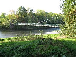
Dryburgh Suspension Bridge is a suspension bridge erected near Dryburgh Abbey, Scottish Borders.
Dryburgh Suspension Bridge | |
|---|---|
| | |
| Coordinates | 55°34′51″N2°39′15″W / 55.580712°N 2.65418°W |
| Crosses | River Tweed |
| Location | |
| | |
Dryburgh Suspension Bridge is a suspension bridge erected near Dryburgh Abbey, Scottish Borders.
The footbridge across the River Tweed was erected in 1872 with a gift intended to allow the Dryburgh villagers to worship at the churches in St. Boswells (part of a ribbon of settlements including Newtown St. Boswells). An earlier bridge nearby, the Dryburgh Abbey Bridge, collapsed in 1818.
It is a relatively simple design with only one suspended span.

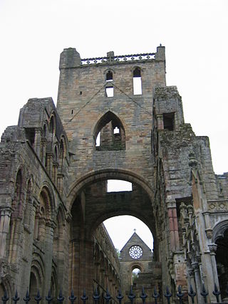
Dryburgh Abbey, near Dryburgh on the banks of the River Tweed in the Scottish Borders, was nominally founded on 10 November (Martinmas) 1150 in an agreement between Hugh de Morville, Constable of Scotland, and the Premonstratensian canons regular from Alnwick Abbey in Northumberland. The arrival of the canons along with their first abbot, Roger, took place on 13 December 1152.
St Cuthbert's Way is a 100-kilometre (62 mi) long-distance trail between the Scottish Borders town of Melrose and Lindisfarne off the coast of Northumberland, England. The walk is named after Cuthbert, a 7th-century saint, a native of the Borders who spent his life in the service of the church. The route links Melrose Abbey, where Cuthbert began his religious life, with his initial burial place on Holy Island. Cuthbert achieved the status of bishop, and was called a saint eleven years after his death, when his coffin was opened and his remains found to be perfectly preserved.

Dryburgh is a village in the Borders region of Scotland, within the county of Berwickshire. It is most famous for the ruined Dryburgh Abbey.
St Boswells is a village on the south side of the River Tweed in the Scottish Borders, about 1 mile southeast of Newtown St Boswells on the A68 road. It lies within the boundaries of the historic county of Roxburghshire.

Scott's View is a viewpoint in the Scottish Borders, overlooking the valley of the River Tweed, which is reputed to be one of the favourite views of Sir Walter Scott.
Greycrook is a village off the A68 and the A699 in the Scottish Borders, approximately 500 m (550 yd) south-east of St Boswells, and close to Dryburgh, Dryburgh Abbey, Maxton, Newtown St Boswells, and the River Tweed.

Bemersyde House is a historic house in Roxburghshire, Scotland.

Angers Bridge, also called the Basse-Chaîne Bridge, was a suspension bridge over the Maine River in Angers, France. It was designed by Joseph Chaley and Bordillon, and built between 1836 and 1839. The bridge collapsed on 16 April 1850, while a battalion of French soldiers were marching across it, killing over 200.

Dryburgh Abbey Bridge was a cable-stayed footbridge of significant historical interest erected near Dryburgh Abbey, in the Borders of Scotland. It connected the villages of Dryburgh and St. Boswells, across the River Tweed. A crossing had existed here for centuries, originally with a ferry service.

Leader Water is a small tributary of the River Tweed in Lauderdale in the Scottish Borders. It flows southwards from the Lammermuir Hills through the towns of Lauder and Earlston, joining the River Tweed at Leaderfoot.

Dryburgh Abbey Hotel is a baronial country house, located on the banks of the River Tweed, in Dryburgh about 5 km south east of Melrose in the Scottish Borders. The modern house was first constructed in 1845 and it was converted into a hotel in 1932. It is next to the ruins of Dryburgh Abbey and part of the former churchyard and its burials are within the grounds.
The Borders Abbeys Way is a long-distance footpath in the Scottish Borders area of Scotland. It is a circular walkway and is 109 kilometres (68 mi) in length. The theme of the footpath is the ruined Borders abbeys along its way: Kelso Abbey, Jedburgh Abbey, Melrose Abbey and Dryburgh Abbey. These abbeys were homes to monks, who lived there between the 12th and 16th centuries. The route also passes through the towns of Hawick and Selkirk, and close to Abbotsford House, the home of Sir Walter Scott. Along the Borders Abbeys Way there are several rivers: Jed Water, River Teviot, River Tweed, Ale Water, and Rule Water.

Bemersyde is a hamlet in the Mertoun parish of Berwickshire, in the Scottish Borders. It sits on the left bank of the River Tweed, about three miles east of Melrose. Bemersyde House, the ancestral home of the Haig family, is the most notable feature.

The William Wallace Statue near the grounds of the Bemersyde estate, near Melrose in the Scottish Borders is a statue commemorating William Wallace. It was commissioned by David Steuart Erskine, 11th Earl of Buchan, and it protected as a category B listed building.

Darnick is a village near Melrose in the Scottish Borders area of Scotland, in the former Roxburghshire. The name was first recorded in 1124, and has changed from Dernewic, Dernwick and Darnwick to the present Darnick. Darnick Tower was built in c. 1425, and another tower house, Fisher's Tower, is still recognisable by its remains.

Clintmains is a village by the River Tweed, in the parish of Mertoun, to the east of Newtown St Boswells, in the Scottish Borders area of Scotland, in the former county of Berwickshire.

Lady Grisell Baillie was the first woman to be created a deaconess in the Church of Scotland.
Dryburgh Bridge may refer to the following footbridges over the Tweed in Scotland:
Mertoun is a parish in the south-west of the historic county of Berwickshire in the Scottish Borders area of Scotland. Together with the parish of Maxton, Roxburghshire it forms the Maxton and Mertoun Community Council area. It was included in the former Ettrick and Lauderdale District of Borders Region, by the Local Government (Scotland) Act 1973, from 1975 to 1996.