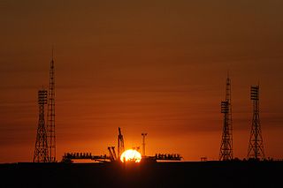
The Baikonur Cosmodrome is a spaceport operated by Russia within Kazakhstan. Located in the Kazakh city of Baikonur, it is the largest operational space launch facility in terms of area. All Russian crewed spaceflights are launched from Baikonur.
The EC postcode area, also known as the London EC postal area, is a group of postcode districts in central London, England. It includes almost all of the City of London and parts of the London boroughs of Islington, Camden, Hackney, Tower Hamlets and Westminster. The area covered is of very high density development. Deliveries for the EC postcode area are made from Mount Pleasant Mail Centre.

Delhi is an ancient centre of Jainism, home to over 165 Jain temples. Delhi has a large population of Jains spread all over the city. It has had continued presence of a Jain community throughout its history, and it is still a major Jain centre.

Crowborough Athletic Football Club is a football club based in Crowborough, East Sussex, England. Affiliated to the Sussex County Football Association, the club are currently members of the Southern Combination Premier Division and play at the Crowborough Community Stadium.
Telephone numbers in Switzerland are defined and assigned according to the Swiss telephone numbering plan administered by the Swiss Federal Office of Communications. The plan has been changed several times and the most recent reorganization was implemented in March 2002.
Horsham and Crawley was a parliamentary constituency centred on the towns of Horsham and Crawley in West Sussex. It returned one Member of Parliament (MP) to the House of Commons of the Parliament of the United Kingdom.

Wyncham Stream is a small river within the London Boroughs of Bexley and Bromley in southeast London, England, United Kingdom. It is 5.6 km (3.5 mi) in length and is a tributary of the River Shuttle.
Duff is a special service area in the Canadian province of Saskatchewan within the Rural Municipality (RM) of Stanley No. 215 and Census Division No. 5. It is approximately 122 kilometres (76 mi) northeast of the City of Regina, 66 kilometres (41 mi) southwest of Yorkton and 20 kilometres (12 mi) west of Melville.

Lingfield Cernes is a 10.3-hectare (25-acre) biological Site of Special Scientific Interest east of Lingfield in Surrey.

The River Stour has been used for centuries as a source of power. Many different processes were performed by the use of water power:- Corn milling, fulling, paper making and electricity generation. Many of the mills survive today as house conversions, with two of them still working commercially.

The Serpent Trail is a 64-mile (103 km) long distance footpath. It runs from Haslemere to Petersfield, which are 11 miles apart in a straight line, by a route which is designed to join up the many heathland areas on greensand in the western Weald. The path takes its name both from its serpentine shape and from passing through habitat of all three British species of snake.

Penn's Rocks is a 10.2-hectare (25-acre) biological Site of Special Scientific Interest north of Crowborough in East Sussex.

Walbrook Wharf is an operating freight wharf in the Port of London located in the City of London adjacent to Cannon Street station. It has been given safeguarded wharf status by the Mayor of London and the Port of London Authority (PLA).

Aghione Airfield is an abandoned World War II military airfield in France, which was located approximately 27 km southeast of Corte on Corsica. It was an all-weather temporary field built by the XII Engineer Command using Pierced Steel Planking for runways and parking areas, as well as for dispersal sites. In addition, tents were used for billeting and also for support facilities; an access road was built to the existing road infrastructure; a dump for supplies, ammunition, and gasoline drums, along with drinkable water and minimal electrical grid for communications and station lighting.
Gipsy Hill ward is an administrative division of the London Borough of Lambeth, England.
North Elizabeth Street is a neighborhood in southwestern Lexington, Kentucky, United States. It is located just west of the University of Kentucky and most of its residents are college students.

Shacklewell Lane Mosque is a Turkish mosque located in Shacklewell, London. Established by Ramadan Güney, his wife Suheyla Güney and other Trustees Turkish Cypriot in 1977, it is the first ever Turkish mosque in the United Kingdom. The mosque is an Andalusian-style building and was previously a synagogue, known as the New Dalston Synagogue.

Whittington's Longhouse was a public toilet in Cheapside, London, constructed with money given or bequeathed by Richard Whittington, Lord Mayor of London. The toilet had 128 seats: 64 for men and 64 for women. It operated from around 1 May 1421, until the seventeenth century.
Karumbakkam is a village located in the Chengalpattu taluk of the Kanchipuram district of the Indian state Tamil Nadu. According to the 2011 Census information, the total geographical area of the village is 184.89 hectares (0.714 sq mi), and the total population is 1,330.
This page is based on this
Wikipedia article Text is available under the
CC BY-SA 4.0 license; additional terms may apply.
Images, videos and audio are available under their respective licenses.
