
Wealden is a local government district in East Sussex, England. Its council is based in Hailsham, the district's second largest town. The district also includes the towns of Crowborough, Polegate and Uckfield, along with numerous villages and surrounding rural areas. The district's name comes from the Weald, the landscape and ancient woodland which occupies much of the centre and north of the area.

Polegate is a town and civil parish in the Wealden District of East Sussex, England, United Kingdom. It is located five miles (8 km) north of the seaside resort of Eastbourne and is part of the greater area of that town. Although once a railway settlement, its rail links were closed as part of the Beeching cuts. The 2011 census put the civil parish of Polegate at a population of 8,586, with 41.2% aged 65 and over.
Cuckmere Valley is a civil parish in the Wealden District of East Sussex, England. As its name suggests, the parish consists of a number of small settlements in the lower reaches of the River Cuckmere.

Glynde and Beddingham Parish Council is a combined council of two civil parishes in the Lewes district of East Sussex.

Buxted is a village and civil parish in the Wealden district of East Sussex in England. The parish is situated on the Weald, north of Uckfield; the settlements of Five Ash Down, Heron's Ghyll and High Hurstwood are included within its boundaries. At one time its importance lay in the Wealden iron industry, and later it became commercially important in the poultry and egg industry.
Alciston is a village and civil parish in the Wealden district of East Sussex, England. It is inland, just off the A27 road, about ten miles (16 km) north-west of Eastbourne and seven miles (11 km) east of Lewes. The ecclesiastical parish is linked with that of Selmeston and Berwick.

Alfriston is a village and civil parish in the East Sussex district of Wealden, England. The village lies in the valley of the River Cuckmere, about four miles (6 km) north-east of Seaford and south of the main A27 trunk road and part of the large area of Polegate. The parish had a population of 829 at the 2011 census.

Arlington is a village and civil parish in the Wealden district of East Sussex, England. The parish is on the River Cuckmere, and is the location of a medieval priory, a reservoir and a car racetrack.

East Dean and Friston is a civil parish in the Wealden District of East Sussex, England.The two villages in the parish are in a dry valley on the South Downs – between Eastbourne three miles (4.8 km) to the east and Seaford an equal distance to the west. The main A259 road goes through both village centres. The coast and much of the land between it and the A259 from the east edge of Seaford to the west edge of Eastbourne is owned by the National Trust, and this has prevented further development to the area. The civil parish was formed on 1 April 1999 from "East Dean" and "Friston" parishes.

Willingdon and Jevington is a civil parish in the Wealden District of East Sussex, England. The two villages lie one mile (1.6 km) south of Polegate. Willingdon is part of the built-up area which is Eastbourne, and lies on the main A22 road, whilst Jevington is on a minor road leading to Friston. The civil parish was formed on 1 April 1999 from "Jevington" and "Willingdon" parishes. Under the name of Willingdon it is also an electoral ward.

Heathfield and Waldron is a civil parish within the Wealden District of East Sussex, England. Heathfield is surrounded by the High Weald Area of Outstanding Natural Beauty. The parish was formed on 1 April 1999 from "Heathfield" and "Waldron" parishes.

Hellingly is a village, and can also refer to a civil parish, and to a district ward, in the Wealden District of East Sussex, England.

Hadlow Down is a village and civil parish in the Wealden district of East Sussex, England. It is located on the A272 road three miles (4.8 km) north-west of Heathfield. The parish is within the High Weald Area of Outstanding Natural Beauty. It came to prominence with the Wealden iron industry in the 17th and 18th centuries. In 2011 the parish had a population of 857. The majority of the population now works outside the parish, but it still has a strong community atmosphere centred on the New Inn pub, St. Mark's school and St. Mark's church.
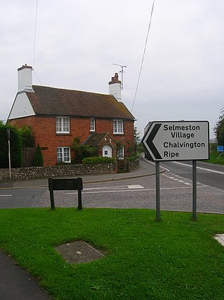
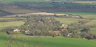
Selmeston is a village and civil parish in the Wealden District of East Sussex, England. It is located eight miles (13 km) east of Lewes, to the north of the A27 road between there and Polegate.
East Chiltington is a village and civil parish in the Lewes District of East Sussex, England. It is centred four miles (5.9 km) south-east of Burgess Hill and five miles (8 km) north-west of Lewes. It is a strip parish of 3.76 square miles (9.7 km2), stretching northward from the crest of the South Downs. The village church is 13th century in origin; the vicar also has charge of two churches in Plumpton. Near the church there is a pub called The Jolly Sportsman. The Sussex Greensand Way, a Roman road, runs from east to west through the centre of the parish.

Iford is a village and civil parish in the Lewes District of East Sussex, England. The village is located two miles (3.2 km) south of Lewes. The parish lies on slopes of the South Downs in the valley of the River Ouse.

Kingston near Lewes is a village and civil parish in the Lewes District of East Sussex, England. The village is mentioned in the Domesday Book and is located two miles (3.2 km) south of Lewes and is nestled in the South Downs. The parish is par of two Sites of Special Scientific Interest: the Lewes Brooks and Kingston Escarpment and Iford Hill.
Lullington is a village and former civil parish, now in the parish of Cuckmere Valley, in the Wealden district, in the county of East Sussex, England. Historically in Sussex, it lies 9⅓ miles southeast of Lewes, on a shoulder of the South Downs at the point where the River Cuckmere cuts through the downs. It faces Alfriston on the opposite bank of the river. In 1961 the parish had a population of 35. On 1 April 1990 the parish was abolished and merged with Litlington and Westdean to form Cuckmere Valley.

The civil parish of Chalvington with Ripe, in the Wealden District of East Sussex, England, is made up of the two villages, Chalvington and Ripe. They are located in the upper Rivers Cuckmere and Ouse joint valley north of the South Downs, between the A27 and the A22 roads, and some 15 miles (24 km) north-west of Eastbourne. Ripe is the larger of the two ecclesiastical parishes with 1,120 acres, compared to the 729 acres of Chalvington. The civil parish was formed on 1 April 1999 from "Chalvington" and "Ripe" parishes.

Litlington is a village and former civil parish, now in the parish of Cuckmere Valley, in the Wealden district, in the county of East Sussex, England. It is focussed 3 miles (4.8 km) ENE of Seaford on the south coast. It was in a roughly square parish of dramatic chalkland that extends down to a natural coastline of pebble beach, Cuckmere Haven. In 1961 the parish had a population of 117. On 1 April 1990 the parish was abolished and merged with Lullington and Westdean to form Cuckmere Valley.


