Ninfield

Last updated • 2 min readFrom Wikipedia, The Free Encyclopedia

Ninfield
Church of St Mary The Virgin Ninfield East Sussex - geograph.org.uk - 97095.jpg
Church of St Mary The Virgin, Ninfield
East Sussex UK location map.svg
Red pog.svg
Ninfield
Location within East Sussex
Area10.6 km2 (4.1 sq mi)  [1]
Population1,562 (2011) [2]
  Density 372/sq mi (144/km2)
OS grid reference TQ706124
  London 49 miles (79 km) NNW
District
Shire county
Region
Country England
Sovereign state United Kingdom
Post town BATTLE
Postcode district TN33
Dialling code 01424
Police Sussex
Fire East Sussex
Ambulance South East Coast
UK Parliament
List of places
UK
England
East Sussex
50°52′59″N0°25′16″E / 50.883°N 0.421°E / 50.883; 0.421

Ninfield is a village and civil parish in the Wealden District of East Sussex, England. The village is quite linear and centred 4 miles (6.4 km) north of Bexhill-on-Sea where two roads cross: the A269 from Bexhill to Battle and the A271 to Hailsham. The parish covers 2,500 acres (1,010 ha); approximately the northern half of which is in the High Weald AONB.

Contents

To the west of the village is Standard Hill, said to be the place that William the Conqueror placed his flag (2 lions of Normandy standard) before the Battle of Hastings. [3] As with many other Wealden villages, it was involved in the iron industry: that fact is commemorated by the presence in the village of a set of iron stocks. Smuggling was also rife in the eighteenth century.

The village name is said to come from the fact that it was originally composed of nine and three quarter fields.[ citation needed ] A legal record, of 1452, mentioning a Sussex village as "Nempnefeld", may refer to Ninfield. [4]

Landmarks

Stocks and a whipping post made of Sussex iron are located by the village green. [5]

Amenities

Ninfield has a primary school, [6] a shop and two pubs- The Kings Arms and the Blacksmiths Inn. It has two churches, its medieval parish church dedicated to St Mary the Virgin; and the Methodist church.

Cultural references and former residents

Ninfield was once featured in an episode of the classic comedy The Goon Show entitled The Nadger Plague and first broadcast by the BBC in October 1956. In the episode, set in the 16th century, the residents of Ninfield were left terrified when two carriers of the titular plague, which caused the seats of peoples' trousers to "burn out", arrived in the village. The episode was written by Spike Milligan, a sometime resident of East Sussex.

James T.A. Osborne (d. 1979), painter, artistic print maker, etcher and engraver long settled in Ninfield.

Local government

The parish council consists of nine councillors. [7]

Ninfield is currently drawn, for the purposes of the fair apportionment of District Councillors as part of electoral ward: Ninfield and Hooe with Wartling. The population of this ward at the 2011 Census was 2,543. [8]

Built-up component

The central, contiguous area of 558 homes on 65 hectares has been identified as a small Built-up Area, in the statistical government bodies definition (ONS and GSS) and had in 2011 a total of 1,307 residents. [9] Population density of this area was 20.1 persons per hectare.

Notable people

eSports participant and sim-racer Jimmy Broadbent is from Ninfield.

Related Research Articles

<span class="mw-page-title-main">Pevensey</span> Village and parish in East Sussex, England

Pevensey is a village and civil parish in the Wealden district of East Sussex, England. The main village is located five miles (8 km) north-east of Eastbourne, one mile (1.6 km) inland from Pevensey Bay. The settlement of Pevensey Bay forms part of the parish. It was here that William the Conqueror made the landing in his invasion of England in 1066 after crossing the English Channel from Normandy.

<span class="mw-page-title-main">Rother District</span> Non-metropolitan district in England

Rother is a local government district in East Sussex, England. Its council is based in Bexhill-on-Sea. The district is named after the River Rother which flows within its boundaries.

Worth is either a civil parish in the Mid Sussex District of West Sussex, or a distinct but historically related village in Crawley.

<span class="mw-page-title-main">Burwash</span> Village and parish in East Sussex, England

Burwash, archaically known as Burghersh, is a rural village and civil parish in the Rother district of East Sussex, England. Situated in the High Weald of Sussex some 15 miles (24 km) inland from the port of Hastings, it is located five miles (8 km) south-west of Hurst Green, on the A265 road, and on the River Dudwell, a tributary of the River Rother. In an area steeped in history, some nine miles (14 km) to the south-east lies Battle Abbey and eight miles (13 km) to the east is Bodiam Castle.

<span class="mw-page-title-main">Long Man</span> Civil parish in East Sussex, England

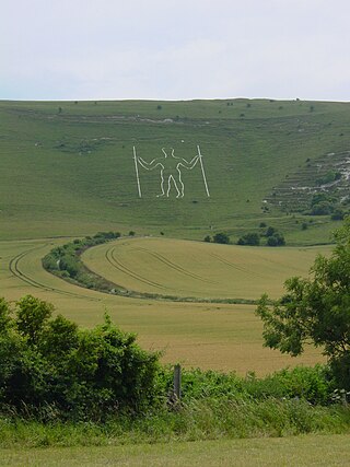
Long Man is a civil parish in the Wealden District of East Sussex, England, which includes the villages of Wilmington, Milton Street and Folkington. The parish is named after the Long Man of Wilmington, a 69.2-metre (227 ft) chalk figure in the parish.

<span class="mw-page-title-main">Horam</span> Village in East Sussex, England

Horam is a village, electoral ward and civil parish in the Wealden District of East Sussex, situated three miles (4.8 km) south of Heathfield. Included in the parish are the settlements of Vines Cross and Burlow.

<span class="mw-page-title-main">Eastbourne (UK Parliament constituency)</span> Parliamentary constituency in the United Kingdom, 1885 onwards

Eastbourne is a constituency for the House of Commons of the UK Parliament. It was created as one of nine in Sussex in 1885, since when it has reduced in geographic size reflecting the growth of its main settlement, Eastbourne. The seat has been represented since 2024 by Josh Babarinde, a Liberal Democrat.

<span class="mw-page-title-main">Bexhill and Battle (UK Parliament constituency)</span> Parliamentary constituency in the United Kingdom, 1983 onwards

Bexhill and Battle is a constituency in East Sussex represented in the House of Commons of the UK Parliament since 2024 by Kieran Mullan of the Conservative Party.

<span class="mw-page-title-main">Buxted</span> Village and parish in Sussex, England

Buxted is a village and civil parish in the Wealden district of East Sussex in England. The parish is situated on the Weald, north of Uckfield; the settlements of Five Ash Down, Heron's Ghyll and High Hurstwood are included within its boundaries. At one time its importance lay in the Wealden iron industry, and later it became commercially important in the poultry and egg industry.

<span class="mw-page-title-main">Hooe, East Sussex</span> Village in East Sussex, England

Hooe is both a small village and a civil parish in the Wealden District of East Sussex; the village being located about two miles (3 km) north-west of Bexhill, and north of the A259 coast road, on the B2095 road from Ninfield. The parish name takes account of local usage, and the location of the parish church; in fact the main population centre is to the north, and is called Hooe Common.

<span class="mw-page-title-main">Ashburnham, East Sussex</span> Parish in East Sussex, England

Ashburnham is a civil parish in the Rother district of East Sussex, England, situated to the west of Battle. It includes the settlements of Brownbread Street and Ponts Green; Ashburnham Forge is also within the parish. Ashburnham shares a parish council with the neighbouring parish of Penhurst.

<span class="mw-page-title-main">Beckley, East Sussex</span> Village and parish in East Sussex, England

Beckley is a village and civil parish in the Rother district of East Sussex, England. It is located on the B2088 minor road above the Rother Levels five miles (8 km) northwest of Rye and ten miles (16 km) from Hastings. The northern border follows the river Rother.

<span class="mw-page-title-main">Penhurst</span> Village in East Sussex, England

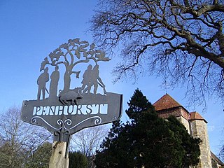
Penhurst is a village and civil parish in the Rother district of East Sussex, England. It is located on the Weald, 4 miles (7km) west of Battle. The parish borders Ashburnham, Battle, Brightling and Catsfield, and shares a parish council with Ashburnham.

<span class="mw-page-title-main">Danehill, East Sussex</span> Village in East Sussex, England

Danehill is a village in East Sussex, England.

<span class="mw-page-title-main">Frant</span> Village and parish in East Sussex, England

Frant is a village and civil parish in the Wealden District of East Sussex, England, on the Kentish border about three miles (5 km) south of Royal Tunbridge Wells.

<span class="mw-page-title-main">Hadlow Down</span> Village and parish in East Sussex, England

Hadlow Down is a village and civil parish in the Wealden district of East Sussex, England. It is located on the A272 road three miles (4.8 km) north-west of Heathfield. The parish is within the High Weald Area of Outstanding Natural Beauty. It came to prominence with the Wealden iron industry in the 17th and 18th centuries. In 2011 the parish had a population of 857. The majority of the population now works outside the parish, but it still has a strong community atmosphere centred on the New Inn pub, St. Mark's school and St. Mark's church.

<span class="mw-page-title-main">Selmeston</span> Village in East Sussex, England

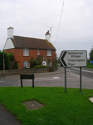
Selmeston is a village and civil parish in the Wealden District of East Sussex, England. It is located eight miles (13 km) east of Lewes, to the north of the A27 road between there and Polegate.

<span class="mw-page-title-main">Wartling</span> Village in East Sussex, England

Wartling is a village and civil parish in the Wealden District of East Sussex, England, between Bexhill and Hailsham, ten miles (16 km) west of the latter at the northern edge of the Pevensey Levels. The parish includes Wartling itself and Boreham Street, two miles (3 km) north-east on the A271 road.

References

  1. "East Sussex in Figures". East Sussex County Council. Retrieved 26 April 2008.
  2. "Civil Parish population 2011" . Retrieved 11 October 2015.
  3. Historical notes, Vision of Britain website
  4. Plea Rolls of the Court of Common Pleas; National Archives; image seen at: 4th entry down; Sussex in the margin; http://aalt.law.uh.edu/AALT3/H6/CP40no764/aCP40no764fronts/IMG_0391.htm
  5. Historic England. "The stocks and whipping-post (Grade II) (1353381)". National Heritage List for England . Retrieved 20 December 2024.
  6. Ninfield CE Primary School website
  7. "The Parish Council representatives". Archived from the original on 29 October 2007. Retrieved 12 May 2008.
  8. "Ninfield and Hooe with Wartling ward population 2011" . Retrieved 11 October 2015.
  9. "Custom report - Nomis - Official Labour Market Statistics".

Commons-logo.svg Media related to Ninfield at Wikimedia Commons