
East Sussex is a ceremonial county in South East England. It is bordered by Kent to the north-east, West Sussex to the west, Surrey to the north-west, and the English Channel to the south. The largest settlement is the city of Brighton and Hove, and the county town is Lewes.

Ashdown Forest is an ancient area of open heathland occupying the highest sandy ridge-top of the High Weald Area of Outstanding Natural Beauty. It is situated some 30 miles (48 km) south of London in the county of East Sussex, England. Rising to an elevation of 732 feet (223 m) above sea level, its heights provide expansive vistas across the heavily wooded hills of the Weald to the chalk escarpments of the North Downs and South Downs on the horizon.

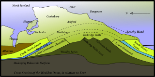
The Weald is an area of South East England between the parallel chalk escarpments of the North and the South Downs. It crosses the counties of Hampshire, Surrey, West Sussex, East Sussex, and Kent. It has three separate parts: the sandstone "High Weald" in the centre; the clay "Low Weald" periphery; and the Greensand Ridge, which stretches around the north and west of the Weald and includes its highest points. The Weald once was covered with forest, and its name, Old English in origin, signifies "woodland". The term is still used today, as scattered farms and villages sometimes refer to the Weald in their names.

Wealden is a local government district in East Sussex, England. Its council is based in Hailsham, the district's largest town. The district also includes the towns of Crowborough, Polegate and Uckfield, along with numerous villages and surrounding rural areas. The district's name comes from the Weald, the landscape and ancient woodland which occupies much of the centre and north of the area.

The High Weald Area of Outstanding Natural Beauty is in south-east England. Covering an area of 1,450 square kilometres (560 sq mi), it takes up parts of Kent, Surrey, East Sussex, and West Sussex. It is the fourth largest Area of Outstanding Natural Beauty (AONB) in England and Wales. It has an attractive landscape with a mosaic of small farms and woodlands, historic parks, sunken lanes and ridge-top villages.

Bolney is a village and civil parish in the Mid Sussex district of West Sussex, England. It lies 36 miles (58 km) south of London, 11 miles (18 km) north of Brighton, and 27 miles (43 km) east northeast of the county town of Chichester, near the junction of the A23 road with the A272 road. The parish has a land area of 1,479.41 hectares. In the 2001 census there were 1209 people living in 455 households of whom 576 were economically active. At the 2011 Census the population had increased to 1,366. Nearby towns include Burgess Hill to the southeast and Haywards Heath to the east.

Hellingly is a village, and can also refer to a civil parish, and to a district ward, in the Wealden District of East Sussex, England.
Ansty and Staplefield, previously Cuckfield Rural, is a civil parish in the Mid Sussex District of West Sussex, England, covering an area from the north-west side of Burgess Hill, the whole lying around but mostly to the west of Cuckfield civil parish, from which it was created in 1894 under the Local Government Act 1894. It includes the settlements of Ansty in the south, Staplefield to the north-west and Brook Street to the north-east. It is the largest civil parish in West Sussex, covering an area of 3,869 hectares (14.94 sq mi), and has a population of 1574, increasing to 1,756 at the 2011 Census.

Nutley is a village in the Wealden District of East Sussex, England. It lies about 5 mi (8.0 km) north-west of Uckfield, the main road being the A22. Nutley, Fairwarp and Maresfield together form the Maresfield civil parish.

The Greensand Ridge, also known as the Wealden Greensand, is an extensive, prominent, often wooded, mixed greensand/sandstone escarpment in south-east England. Forming part of the Weald, a former dense forest in Sussex, Surrey and Kent, it runs to and from the East Sussex coast, wrapping around the High Weald and Low Weald. It reaches its highest elevation, 294 metres (965 ft), at Leith Hill in Surrey—the second highest point in south-east England, while another hill in its range, Blackdown, is the highest point in Sussex at 280 metres (919 ft). The eastern end of the ridge forms the northern boundary of Romney Marsh.
Kent is the south-easternmost county in England. It is bounded on the north by the River Thames and the North Sea, and on the south by the Straits of Dover and the English Channel. The continent of Europe is 21 miles across the straits.
St Leonard's Forest is at the western end of the Wealden Forest Ridge which runs from Horsham to Tonbridge, and is part of the High Weald Area of Outstanding Natural Beauty. It lies on the ridge to the south of the A264 between Horsham and Crawley with the villages of Colgate and Lower Beeding within it. The A24 lies to west and A23 to the East and A272 through Cowfold to the south. Much has been cleared, but a large area is still wooded. Forestry England has 289 ha. which is open to the public, as are Owlbeech and Leechpool Woods to the east of Horsham, and Buchan Country Park to the SW of Crawley. The rest is private with just a few public footpaths and bridleways. Leonardslee Gardens were open to the public until July 2010 and re-opened in April 2019. An area of 85.4 hectares is St Leonards Forest Site of Special Scientific Interest.

The London to Lewes Way is a 71 kilometres (44 mi) long Roman road between Watling Street at Peckham and Lewes in Sussex. The road passes through Beckenham and West Wickham, then crosses the North Downs above Titsey, on the county boundary between Surrey and Kent, and is overlain by Edenbridge High Street. The road continues on this alignment onto the high ground of Ashdown Forest, where the more grassy vegetation on the silted up outer ditches contrasts very clearly with surrounding heather in aerial photographs, then descends through Piltdown to Lewes, linking with the Sussex Greensand Way at Barcombe Mills and with a network of roads at Lewes.
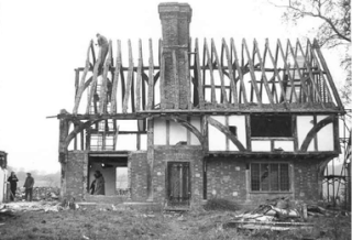
The Wealden hall house is a type of vernacular medieval timber-framed hall house traditional in the south east of England. Typically built for a yeoman, it is most common in Kent and the east of Sussex but has also been built elsewhere. Kent has one of the highest concentrations of such surviving medieval timber-framed buildings in Europe.

The geology of East Sussex is defined by the Weald–Artois anticline, a 60 kilometres (37 mi) wide and 100 kilometres (62 mi) long fold within which caused the arching up of the chalk into a broad dome within the middle Miocene, which has subsequently been eroded to reveal a lower Cretaceous to Upper Jurassic stratigraphy. East Sussex is best known geologically for the identification of the first dinosaur by Gideon Mantell, near Cuckfield, to the famous hoax of the Piltdown man near Uckfield.
Ashdown Forest formed an important part of the Wealden iron industry that operated from pre-Roman times until the early 18th century. The industry reached its peak in the two periods when the Weald was the main iron-producing region of Britain, namely in the first 200 years of the Roman occupation and during Tudor and early Stuart times. Iron-smelting in the former period was based on bloomery technology, while the latter depended for its rapid growth on the blast furnace, when the Ashdown area became the first in England to use this technology.

Ashdown Forest contains a wealth of archeological features. Absence of ploughing, predominance of heathland and lack of building development have allowed archaeological sites to survive and remain visible. More than 570 such sites have been identified, including Bronze Age round barrows, Iron Age enclosures, prehistoric field systems, iron workings from Roman times onwards, the Pale, medieval and post-medieval pillow mounds for the rearing of rabbits, and a set of military kitchen mounds between Camp Hill and Nutley dating from 1793 that are among the only surviving ones in the United Kingdom. The earliest known trace of human activity in Ashdown Forest is a stone hand axe found near Gills Lap, which is thought to be about 50,000 years old. The vast majority of finds however date from the Mesolithic and onwards into the modern era.

The Ashdown Formation is a geological unit, which forms part of the Wealden Group and the lowermost and oldest part of the now unofficial Hastings Beds. These geological units make up the core of the Weald in the English counties of East Sussex and Kent.

The Wadhurst Clay Formation is a geological unit which forms part of the Wealden Group and the middle part of the now unofficial Hastings Beds. These geological units make up the core of the geology of the High Weald in the English counties of West Sussex, East Sussex and Kent.
The geology of Kent in southeast England largely consists of a succession of northward dipping late Mesozoic and Cenozoic sedimentary rocks overlain by a suite of unconsolidated deposits of more recent origin.
