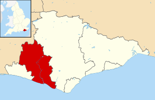
Wealden is a local government district in East Sussex, England. Its council is based in Hailsham, the district's second largest town. The district also includes the towns of Crowborough, Polegate and Uckfield, along with numerous villages and surrounding rural areas. The district's name comes from the Weald, the landscape and ancient woodland which occupies much of the centre and north of the area.
Lewes is a local government district in East Sussex, England. The district is named after the town of Lewes. The largest town is Seaford. The district also includes the towns of Newhaven, Peacehaven and Telscombe and numerous villages and surrounding rural areas. The council meets in Lewes and has its main offices in Newhaven.

Polegate is a town and civil parish in the Wealden District of East Sussex, England, United Kingdom. It is located five miles (8 km) north of the seaside resort of Eastbourne and is part of the greater area of that town. Although once a railway settlement, its rail links were closed as part of the Beeching cuts. The 2011 census put the civil parish of Polegate at a population of 8,586, with 41.2% aged 65 and over.
Cuckmere Valley is a civil parish in the Wealden District of East Sussex, England. As its name suggests, the parish consists of a number of small settlements in the lower reaches of the River Cuckmere.
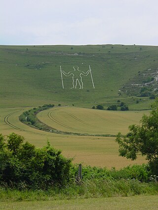
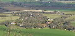
Long Man is a civil parish in the Wealden District of East Sussex, England, which includes the villages of Wilmington, Milton Street and Folkington. The parish is named after the Long Man of Wilmington, a 69.2-metre (227 ft) chalk figure in the parish.

Lewes is a constituency in East Sussex represented in the House of Commons of the UK Parliament since 2024 by James MacCleary, a Liberal Democrat.
Firle is a village and civil parish in the Lewes district of East Sussex, England. Firle refers to an Old English word fierol meaning overgrown with oak.

Buxted is a village and civil parish in the Wealden district of East Sussex in England. The parish is situated on the Weald, north of Uckfield; the settlements of Five Ash Down, Heron's Ghyll and High Hurstwood are included within its boundaries. At one time its importance lay in the Wealden iron industry, and later it became commercially important in the poultry and egg industry.

Alfriston is a village and civil parish in the East Sussex district of Wealden, England. The village lies in the valley of the River Cuckmere, about four miles (6 km) north-east of Seaford and south of the main A27 trunk road and part of the large area of Polegate. The parish had a population of 829 at the 2011 census.

Beckley is a village and civil parish in the Rother district of East Sussex, England. It is located on the B2088 minor road above the Rother Levels five miles (8 km) northwest of Rye and ten miles (16 km) from Hastings. The northern border follows the river Rother.
Berwick is a village and civil parish in the Wealden district of East Sussex in England. The village lies immediately to the south of the A27 road between Lewes and Polegate, about three miles (4.8 km) west of the latter. The parish is located in the River Cuckmere floodplain, north of the South Downs.
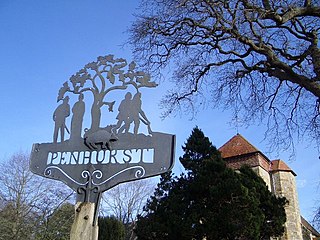
Penhurst is a village and civil parish in the Rother district of East Sussex, England. It is located on the Weald, 4 miles (7km) west of Battle. The parish borders Ashburnham, Battle, Brightling and Catsfield, and shares a parish council with Ashburnham.

Danehill is a village in East Sussex, England.
Piddinghoe is a village and civil parish in the Lewes District of East Sussex, England. It is located in the valley of the River Ouse between Lewes and Newhaven, five miles (8 km) south of the former, downstream of Southease.
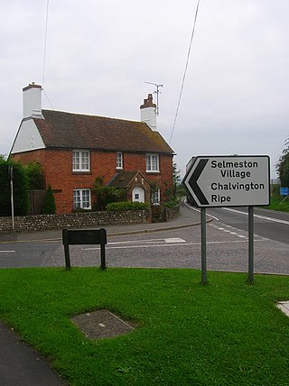
Selmeston is a village and civil parish in the Wealden District of East Sussex, England. It is located eight miles (13 km) east of Lewes, to the north of the A27 road between there and Polegate.

Kingston near Lewes is a village and civil parish in the Lewes District of East Sussex, England. The village is mentioned in the Domesday Book and is located two miles (3.2 km) south of Lewes and is nestled in the South Downs. The parish is par of two Sites of Special Scientific Interest: the Lewes Brooks and Kingston Escarpment and Iford Hill.

South Heighton is a village and civil parish in the Lewes District of East Sussex, England. The village is seven miles (12 km) south of Lewes. In the 1890s the village's population grew from less than 100 to over 500 after a cement manufacturing plant opened nearby. The village is now associated with the urbanised area of Newhaven.

Tarring Neville is a village and civil parish in the Lewes district of East Sussex, England. The village is located five miles (8 km) south of Lewes, on the A26 road to Newhaven. The south west border of the parish runs along the River Ouse, the parish extending into the South Downs. In 1971 the parish had a population of 36.

The civil parish of Chalvington with Ripe, in the Wealden District of East Sussex, England, is made up of the two villages, Chalvington and Ripe. They are located in the upper Rivers Cuckmere and Ouse joint valley north of the South Downs, between the A27 and the A22 roads, and some 15 miles (24 km) north-west of Eastbourne. Ripe is the larger of the two ecclesiastical parishes with 1,120 acres, compared to the 729 acres of Chalvington. The civil parish was formed on 1 April 1999 from "Chalvington" and "Ripe" parishes.
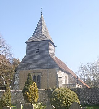
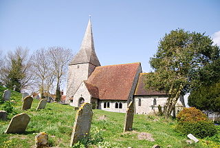
St Mary and St Peter's Church is in the village of Wilmington, East Sussex, England. It is an active Anglican parish church on the deanery of Lewes and Seaford, the archdeaconry of Lewes and Hastings, and the diocese of Chichester. Founded in the late 11th century to serve villagers in a rural area at the foot of the South Downs, it also functioned as a priory church for the monks from the adjacent Wilmington Priory, to which it was physically connected. The building has "benefited from sympathetic restoration" over the centuries—including a series of works by prominent architects Paley and Austin in the Victorian era, and internal renovation after a fire in the early 21st century. The church is recorded in the National Heritage List for England as a designated Grade I listed building.