
Yalobusha County is a county located in the U.S. state of Mississippi. As of the 2010 census, the population was 12,678. It has two county seats, Water Valley and Coffeeville.

Kaskaskia is a village in Randolph County, Illinois. Having been inhabited by indigenous peoples, it was settled by France as part of the Illinois Country. It was named for the Kaskaskia people. Its population peaked at about 7,000 in the 18th century, when it was a regional center. During the American Revolutionary War, the town, which by then had become an administrative center for the British Province of Quebec, was taken by the Virginia militia during the Illinois campaign. It was designated as the county seat of Illinois County, Virginia, after which it became part of the Northwest Territory in 1787. Kaskaskia was later named as the capital of the United States' Illinois Territory, created on February 3, 1809. In 1818, when Illinois became the 21st U.S. state, the town briefly served as the state's first capital until 1819, when the capital was moved to more centrally located Vandalia.

Kiln is an unincorporated community and census-designated place (CDP) in Hancock County, Mississippi, United States. The town is located about 50 miles (80 km) northeast of New Orleans, Louisiana. It is part of the Gulfport-Biloxi Metropolitan Statistical Area. The population was 2,238 at the 2010 census.

Scooba is a town in Kemper County, Mississippi, United States. The population was 732 at the 2010 census.

Liberty is a city in Pickens County, South Carolina, United States. It is part of the Greenville–Mauldin–Easley Metropolitan Statistical Area. The city was chartered on March 2, 1876.

Grafton is a village in Ozaukee County, Wisconsin, United States. Located about 20 miles (32 km) north of Milwaukee and in close proximity to Interstate 43, it is a suburban community in the Milwaukee metropolitan area. The village incorporated in 1896, and at the time of the 2010 census the population was 11,459.
The Village of Holly Bluff is a small unincorporated community in Yazoo County, Mississippi, in the Mississippi Delta.

Lizana is an unincorporated community located in Harrison County, Mississippi. Lizana is approximately 9.8 miles (15.8 km) southwest of Saucier along Mississippi Highway 53.
McHenry, is an unincorporated community in southern Stone County, Mississippi. It is situated approximately 10 miles (16 km) south of Wiggins and 3 miles (4.8 km) north of Saucier. The community is part of the Gulfport-Biloxi metropolitan area.
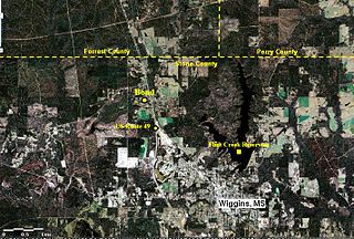
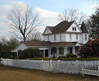
Bond is a census-designated place and unincorporated community in northern Stone County, Mississippi, United States. The community is situated approximately 3 miles (4.8 km) north of Wiggins on U.S. Route 49, and is part of the Gulfport-Biloxi metropolitan area.
The lost towns are a group of places that are still commonly used by county residents. Each was at one time a post office, a store that served a part of the county, a grain elevator used by farmers to ship their crops, or a development that was or may still remain a unique designation. There may be a residential association or some other legal body devoted to the area. More often, these communities are communities of people who still refer to their homes by these geographic designations.

Peoria is an unincorporated community in Liberty Township, Union County, Ohio, United States. It is located at 40°18′50″N83°26′45″W, along Raymond Road, about 1.75 miles south of Raymond and 6.5 miles northwest of Marysville.
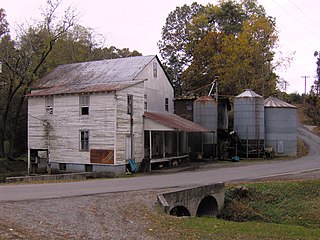
The Clover Hill Mill is a gristmill located in the U.S. city of Maryville, Tennessee. Out of the hundreds of early-20th century mills once scattered across the mountains of East Tennessee, the Clover Hill Mill is one of the few still in operation, and the last such full service mill in Blount County. The mill was added to the National Register of Historic Places in 1989.
Leaf is a census-designated place and unincorporated community in Greene County, Mississippi, United States.
Lawrence is an unincorporated community in Newton County, Mississippi, United States.
Winchester is a ghost town in Wayne County, Mississippi, United States.

Jackson, also known as Jackson Station, is an unincorporated community in Cicero Township, Tipton County, in the U.S. state of Indiana.

Binnsville is a ghost town in Kemper County, Mississippi, United States.
Stratton is an unincorporated community located in Newton County, Mississippi, United States.
Battlefield is an unincorporated community located in Newton County, Mississippi United States. Its zip code is 39325.


