Earl Peak

Last updated
Earl Peak
Earl Peak from near Navaho Peak.jpg
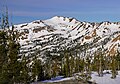
Earl Peak, east aspect
Highest point
Elevation 7,036 ft (2,145 m) [1]
Prominence 956 ft (291 m) [1]
Parent peak Navaho Peak (7,223 ft) [2]
Isolation 2.05 mi (3.30 km) [2]
Coordinates 47°24′36″N120°50′34″W / 47.410011°N 120.842858°W / 47.410011; -120.842858 [1]
Geography
USA Washington relief location map.jpg
Red triangle with thick white border.svg
Earl Peak
Location of Earl Peak in Washington
Usa edcp relief location map.png
Red triangle with thick white border.svg
Earl Peak
Earl Peak (the United States)
CountryUnited States
State Washington
County Kittitas
Parent range Wenatchee Mountains
Cascade Range
Topo map USGS Enchantment Lakes
Climbing
Easiest route class 2 scrambling

Earl Peak is a 7,036-foot (2,145-metre) mountain summit located on the edge of the Alpine Lakes Wilderness, in Kittitas County of Washington state. [3] Earl Peak is the eighth-highest point in the Teanaway area of the Wenatchee Mountains. [1] It is situated two miles southwest of Navaho Peak, on land managed by Wenatchee National Forest. Precipitation runoff from the peak drains south into tributaries of the Teanaway River, or north into Hardscrabble Creek which is part of the Wenatchee River drainage basin. The view from the summit of this peak showcases the impressive Mount Stuart and Stuart Range for those who climb it.

Contents

Climate

Lying east of the Cascade crest, the area around Earl Peak is a bit drier than areas to the west. Summers can bring warm temperatures and occasional thunderstorms. Weather fronts originating in the Pacific Ocean travel east toward the Cascade Mountains. As fronts approach, they are forced upward by the peaks of the Cascade Range, causing them to drop their moisture in the form of rain or snow onto the Cascades (Orographic lift). As a result, the eastern slopes of the Cascades experience lower precipitation than the western slopes. During winter months, weather is usually cloudy, but due to high pressure systems over the Pacific Ocean that intensify during summer months, there is often little or no cloud cover during the summer. [4]

See also

Related Research Articles

<span class="mw-page-title-main">Chikamin Peak</span> Mountain in Washington (state), United States

Chikamin Peak is a 6,994-foot (2,132-metre) mountain summit located in the Cascade Range, in Kittitas County of Washington state. It is situated within the Alpine Lakes Wilderness on land managed by the Okanogan–Wenatchee National Forest. The mountain's name "Chikamin" derives from Chinook Jargon meaning "money" or "metal", and was submitted by Edmond S. Meany, president of The Mountaineers. This name was officially adopted in 1916 by the U.S. Board on Geographic Names. Chikamin Peak is the highest point of Chikamin Ridge, six miles (9.7 km) northeast of Snoqualmie Pass. Other notable peaks on Chikamin Ridge include Four Brothers and Three Queens. Precipitation runoff from this mountain drains into tributaries of the Yakima River. The Pacific Crest Trail traverses the southwest slope of Chikamin Ridge, and from the trail a scramble up a gully leads to the summit and several alpine lakes including Chikamin Lake and Spectacle Lake.

<span class="mw-page-title-main">Prusik Peak</span> Mountain in Washington (state), United States

Prusik Peak is an 8,008-foot (2,441-metre) granite summit located at the west end of The Temple in Chelan County of Washington state. Prusik Peak is part of The Enchantments within the Alpine Lakes Wilderness and is often the iconic photographic image of both areas. Prusik Peak belongs to the Stuart Range which is a subset of the Cascade Range. The toponym honors Dr. Karl Prusik (1896–1961) who was an Austrian mountaineer, known as the inventor of the prusik, a rope knot which happened to be used to gain access to the summit horn during the first ascent by Fred Beckey in 1948. Precipitation runoff drains into Icicle Creek which is a tributary of the Wenatchee River.

<span class="mw-page-title-main">Little Annapurna</span> Mountain in Washington (state), United States

Little Annapurna is an 8,485-foot (2,586-metre) mountain summit located in Chelan County of Washington state. The origin of the name came from the Sherpa Climbing Club of Ellensburg and is inspired by the obvious resemblance to its Himalayan namesake when comparing the south faces of both. Little Annapurna is part of The Enchantments within the Alpine Lakes Wilderness and is set on land managed by the Okanogan–Wenatchee National Forest. It belongs to the Stuart Range which is subset of the Cascade Range. Little Annapurna is situated southeast of Dragontail Peak, which is the nearest higher neighbor. Remnants of the receding Snow Creek Glacier can be found on its gentle north slope. Precipitation runoff drains into tributaries of the Wenatchee River.

<span class="mw-page-title-main">Cannon Mountain (Washington)</span> Mountain in Washington (state), United States

Cannon Mountain is an 8,652-foot (2,637 meter) mountain summit located in Chelan County of Washington state. Cannon Mountain is part of The Enchantments, within the Alpine Lakes Wilderness. Cannon Mountain belongs to the Stuart Range which is subset of the Cascade Range. Cannon Mountain is situated one mile north of Enchantment Peak. The nearest higher peak is Dragontail Peak, 2.15 mi (3.46 km) to the southwest. Precipitation runoff from the slopes drains into Icicle Creek, which is a tributary of the Wenatchee River.

<span class="mw-page-title-main">Colchuck Peak</span> Mountain in Washington (state), United States

Colchuck Peak is an 8,705-foot (2,653-metre) mountain summit located in the Stuart Range, in the Alpine Lakes Wilderness in Chelan County of Washington state. The nearest higher peak is Dragontail Peak, 0.49 mi (0.79 km) to the east, and Argonaut Peak lies 0.9 mi (1.4 km) to the southwest. The Colchuck Glacier which lies on the northeast slopes of the peak melts into Colchuck Lake. The mountain and glacier take their name from the lake, which in Chinook jargon means "cold water". Precipitation runoff from the peak drains north into Mountaineer Creek, a tributary of Icicle Creek, or south into Ingalls Creek, all of which winds up in the Wenatchee River. Colchuck Peak is more notable for its steep rise above local terrain than for its absolute elevation as topographic relief is significant with the summit rising 3,130 feet (954 m) above Colchuck Lake in 1 mi (1.6 km), and 4,600 feet (1,402 m) above Ingalls Creek in 1.9 mi (3.1 km).

<span class="mw-page-title-main">Sherpa Peak</span> Mountain in Washington (state), United States

Sherpa Peak is an 8,630-foot (2,630-metre) granite summit located in the Stuart Range, in the Alpine Lakes Wilderness in Chelan County of Washington state. The nearest higher peak is Mount Stuart, 0.41 mi (0.66 km) to the west, and Argonaut Peak lies 1.29 mi (2.08 km) to the east. The Sherpa Glacier lies on the northern slope of the peak. Precipitation runoff from the peak drains north into Mountaineer Creek, a tributary of Icicle Creek, or south into Ingalls Creek, all of which winds up in the Wenatchee River. According to the USGS, this peak is named for a local climbing club that was active in the area in the 1950s, and the toponym was officially adopted in 1988 by the U.S. Board on Geographic Names.

<span class="mw-page-title-main">Ingalls Peak</span> Mountain in Washington (state), United States

Ingalls Peak is a 7,662-foot (2,335-metre) triple-summit mountain located in the Alpine Lakes Wilderness, along the common border of Kittitas County and Chelan County, in Washington state. Ingalls Peak is the highest point in the Teanaway area of the Wenatchee Mountains. It is situated 2 mi (3.2 km) west of Mount Stuart, and immediately west of Lake Ingalls, on land managed by Wenatchee National Forest. Its subpeaks are the South Peak and the East Peak. Precipitation runoff from the peak drains north into Jack Creek, a tributary of Icicle Creek; west into Fortune Creek; or east into Ingalls Creek, a tributary of the Wenatchee River. This peak, the lake, creek, and pass are named for Captain Benjamin Ingalls of the United States Cavalry who led an 1855 survey of this area and is credited with discovering gold in the region.

<span class="mw-page-title-main">Eightmile Mountain</span> Mountain in Washington (state), United States

Eightmile Mountain is a 7,996-foot (2,437-metre) mountain summit located in Chelan County of Washington state. Eightmile Mountain is situated within the Alpine Lakes Wilderness, on land managed by the Okanogan–Wenatchee National Forest. It is part of the Wenatchee Mountains which are a subset of the Cascade Range. Its nearest higher neighbor is Cashmere Mountain, 3 mi (4.8 km) to the northeast, and Mount Stuart rises 4 mi (6.4 km) to the south. Precipitation runoff from the mountain drains into Trout Creek and Eightmile Creek, both tributaries of Icicle Creek, which in turn is a tributary of the Wenatchee River. This mountain is known for its spring skiing and excellent view of the Stuart Range.

<span class="mw-page-title-main">Grindstone Mountain (Washington)</span> Mountain in Washington (state), United States

Grindstone Mountain is a 7,533-foot (2,296-metre) mountain summit located in the Icicle Creek Valley in Chelan County of Washington state. Grindstone Mountain is situated 12 mi (19 km) west of Leavenworth, within the Alpine Lakes Wilderness, on land managed by the Okanogan–Wenatchee National Forest. Grindstone Mountain is the seventh-highest peak in the Chiwaukum Mountains, a subset of the Cascade Range. Its nearest higher neighbor is Ladies Peak, 2.2 mi (3.5 km) to the north-northwest, and Cape Horn is set 1.4 mi (2.3 km) to the north. Precipitation runoff from Grindstone drains into Icicle Creek, which is a tributary of the Wenatchee River. Although modest in elevation, relief is significant since Grindstone rises 4,700 feet above Icicle Creek Valley in less than two miles. Grindstone Mountain was named by Albert Hale Sylvester in association with Grindstone Creek, which flows from Sylvester Lake on this mountain's southwest slope. Sylvester found a small grindstone which had fallen from a pack horse fording the creek.

<span class="mw-page-title-main">Navaho Peak</span> Mountain in Washington (state), United States

Navaho Peak is a 7,223-foot (2,202-metre) mountain summit located on the boundary of the Alpine Lakes Wilderness, on the shared border of Kittitas County with Chelan County in Washington state. Navaho Peak is the fourth-highest point in the Teanaway area of the Wenatchee Mountains. It is situated two miles northeast of Earl Peak, and 1.3 miles west of Three Brothers, on land managed by Wenatchee National Forest. Precipitation runoff from the peak drains south into tributaries of the Teanaway River, or north into tributaries of Ingalls Creek which is part of the Wenatchee River drainage basin. The view from the summit of this peak showcases the impressive Mount Stuart and Stuart Range for those who climb it.

<span class="mw-page-title-main">Bills Peak</span> Mountain in Washington (state), United States

Bills Peak is a 6,917-foot (2,108-metre) mountain summit located on the common border of Kittitas County with Chelan County in Washington state. It is the tenth-highest point in the Teanaway area of the Wenatchee Mountains. Bills Peak is situated 2.6 mi (4.2 km) west-northwest of Earl Peak, its nearest higher neighbor, on the boundary of the Alpine Lakes Wilderness, on land managed by Wenatchee National Forest. Precipitation runoff from the peak drains south into tributaries of the Teanaway River, or north into tributaries of Ingalls Creek which is part of the Wenatchee River drainage basin. The view from the summit of this peak showcases the impressive Mount Stuart and Stuart Range. Bills Peak was named after William Noble "Bill" Prater (1926–2010), a mountaineer and farmer from nearby Ellensburg.

<span class="mw-page-title-main">Teanaway Peak</span> Mountain in Washington (state), United States

Teanaway Peak is a 6,779-foot (2,066-metre) mountain summit located in the Wenatchee Mountains, on the shared border of Kittitas County with Chelan County in Washington state. It is situated on the boundary of the Alpine Lakes Wilderness, on land managed by Wenatchee National Forest. Its nearest higher neighbor is Bills Peak, 0.72 mi (1.16 km) to the east. Precipitation runoff from the peak drains south into tributaries of the Teanaway River, or north into Turnpike Creek which is part of the Wenatchee River drainage basin. The view from the summit of this peak showcases the impressive Mount Stuart and Stuart Range for those who climb it. This peak also goes by the name "Genes Peak", which is for Gene Prater (1929–1993), the younger brother of Bill Prater, for whom Bills Peak was named. Gene was co-inventor of the modern aluminum snowshoe, and author of the seminal book, "Snowshoeing: From Novice to Master." Gene is also credited with first ascents of Sherpa Peak, Colchuck Balanced Rock, and the east summit of Ingalls Peak.

<span class="mw-page-title-main">Fortune Peak</span> Mountain in Washington (state), United States

Fortune Peak is a 7,382-foot (2,250-metre) mountain summit located along the common border of Kittitas County and Chelan County, in Washington state. Fortune Peak is the second-highest point in the Teanaway area of the Wenatchee Mountains. It is situated 0.74 mi (1.19 km) south-southwest of Ingalls Peak, and southwest of Lake Ingalls, on the Alpine Lakes Wilderness boundary, on land managed by Wenatchee National Forest. Precipitation runoff from the peak drains northwest into Fortune Creek, a tributary of Cle Elum River; south into tributaries of Teanaway River; or east into Ingalls Creek which is part of the Wenatchee River drainage basin. This peak is unofficially named for its position at the head of Fortune Creek. This creek was where the Queen of the Hills and Ruby Mines were located. Queen of the Hills was a lode gold mine, whereas the Ruby Mine produced antimony, copper, lead, and silver with a by-product of gold.

<span class="mw-page-title-main">Hawkins Mountain</span> Mountain in Washington (state), United States

Hawkins Mountain is a 7,160+ ft double-summit massif located in Kittitas County of Washington state. Hawkins Mountain is the sixth-highest point in the Teanaway area of the Wenatchee Mountains. The lower (7,080-ft) east summit is also known as Hawkins Thimble. Hawkins is situated three miles southwest of Ingalls Peak, and 1.7 mi (2.7 km) northwest of Esmeralda Peaks, on land managed by Wenatchee National Forest. Precipitation runoff from the peak drains into tributaries of the Teanaway River and Cle Elum River. This mountain was named for prospector Samuel S. Hawkins.

<span class="mw-page-title-main">Esmeralda Peaks</span> Mountain in Washington (state), United States

Esmeralda Peaks is a 6,765 ft (2,060 m) multi-summit mountain located in Kittitas County of Washington state. Esmeralda Peaks are in the Teanaway area of the Wenatchee Mountains. Esmeralda Peaks is situated 2.4 mi (3.9 km) south of Ingalls Peak, and 1.7 mi (2.7 km) southeast of Hawkins Mountain, on land managed by Wenatchee National Forest. Precipitation runoff from the peaks drains into tributaries of the Teanaway River. This mountain's name has also been spelled Esmerelda Peaks, however Esmeralda was officially adopted in 1966 by the U.S. Board on Geographic Names.

<span class="mw-page-title-main">Harding Mountain</span> Mountain in Washington (state), United States

Harding Mountain is a 7,173 ft (2,190 m) mountain summit located in Chelan County of Washington state. It is the seventh-highest point in the North Wenatchee Mountains. Harding Mountain is situated within the Alpine Lakes Wilderness, 5.35 mi (8.61 km) northwest of Mount Stuart, and 4.1 mi (6.6 km) west of Eightmile Mountain, on land managed by Wenatchee National Forest. Precipitation runoff from the peak drains into tributaries of Icicle Creek, which in turn is a tributary of the Wenatchee River. This mountain was named after President Warren G. Harding by Albert Hale Sylvester.

<span class="mw-page-title-main">Cape Horn (Washington)</span> Mountain in Washington (state), United States

Cape Horn is a 7,316-foot (2,230-metre) mountain summit located in Chelan County of Washington state. Cape Horn is situated 12 mi (19 km) west-northwest of Leavenworth, within the Alpine Lakes Wilderness, on land managed by the Okanogan–Wenatchee National Forest. Cape Horn is part of the Chiwaukum Mountains, a subset of the Cascade Range. The nearest higher neighbor is Ladies Peak, 0.9 mi (1.4 km) to the northwest, and Grindstone Mountain is set 1.4 mi (2.3 km) to the south. Precipitation runoff from Cape Horn drains west to Icicle Creek, whereas the east slopes drain into Chiwaukum Creek, and both are tributaries of the Wenatchee River. Although modest in elevation, relief is significant since this peak rises over 4,300 feet above Icicle Creek Valley in approximately two miles. This mountain was named by Albert Hale Sylvester in 1909 for its sharp profile.

<span class="mw-page-title-main">Three Brothers (Washington)</span> Mountain in Washington (state), United States

Three Brothers is a 7,303-foot-elevation triple-peak mountain summit located in Chelan County of Washington state. It is situated 1.3 miles east of Navaho Peak, on the boundary of the Alpine Lakes Wilderness, on land managed by Wenatchee National Forest. Three Brothers is the third-highest point in the Teanaway area of the Wenatchee Mountains. Precipitation runoff from the peak drains into tributaries of the Wenatchee River. The view from the summit of this peak showcases the impressive Mount Stuart and Stuart Range for those who climb it.

<span class="mw-page-title-main">French Cabin Mountain</span> Mountain in Washington (state), United States

French Cabin Mountain is a triple-peak mountain located in Kittitas County of Washington state. The highest summit is West Peak, elevation 5,724-feet, the South Peak is 5,560-feet-elevation, and the North Peak is 5,498-feet. French Cabin Mountain is situated six miles north of Easton, between Kachess Lake and Cle Elum Lake, on land managed by Okanogan-Wenatchee National Forest. Precipitation runoff from the mountain drains north into French Cabin Creek and south into Silver Creek, which are both part of the Yakima River drainage basin. Topographic relief is significant as the summit rises 1,700 feet above Silver Creek in one mile, and the east aspect rises 3,400 feet above Cle Elum Lake in one and a half miles (2.4 km). French Cabin Mountain is the toponym officially adopted by the U.S. Board on Geographic Names, however "Frenchman Mountain" is a variant. West Peak is also an official toponym.

<span class="mw-page-title-main">Wedge Mountain (Washington)</span> Mountain in Washington (state), United States

Wedge Mountain is a 5,860-foot-elevation (1,786-meter) summit located in Chelan County of Washington state. It is set on the boundary line of the Alpine Lakes Wilderness, on land managed by Okanogan-Wenatchee National Forest. Wedge Mountain is the northeastern terminus of the Stuart Range, which is a subset of the Cascade Range. It is situated 3.5 miles (5.6 km) northeast of The Temple, and the nearest town is Leavenworth, 5 miles (8.0 km) to the north-northeast. Precipitation runoff from the mountain drains into tributaries of the Wenatchee River. Topographic relief is significant as the summit rises over 2,800 feet above Snow Creek in one-half mile. Backpackers hiking en route to The Enchantments via the Snow Creek Trail traverse the western foot of this mountain. Wedge Mountain is the toponym officially adopted by the U.S. Board on Geographic Names for the 5,860-foot summit.

References

  1. 1 2 3 4 "Earl Peak, Washington". Peakbagger.com.
  2. 1 2 "Earl Peak - 7,036' WA". listsofjohn.com. Retrieved 2020-07-04.
  3. "Earl Peak". Geographic Names Information System . United States Geological Survey, United States Department of the Interior . Retrieved 2020-07-04.
  4. Beckey, Fred W. Cascade Alpine Guide, Climbing and High Routes. Seattle, WA: Mountaineers Books, 2008.