Related Research Articles

Dularcha is a national park in Queensland, Australia, 78 km north of Brisbane. The park occupies a north east portion of Landsborough. It is bisected by the North Coast railway line. The park covers an area of 4.64 km2 (1.79 sq mi). It lies within the Mooloolah River water catchment area of the South East Queensland bioregion.
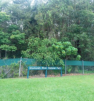
The Mooloolah River National Park is a nationally protected area located on the Sunshine Coast, Queensland. It covers an area of 830.9 hectares and is bordered by the Mooloolah River to the east, Claymore and Dixon Roads to the west, and the Lower Mooloolah River Environmental Reserve to the south. It is bisected by the Sunshine Motorway with the northern, 161.93 hectare component of the Park being a later addition. The Park was initially vacant crown land prior to national park designation in 1960. Surrounding land uses include livestock grazing, urban development and the campus of the University of the Sunshine Coast. It is the second largest mainland park on the coastal lowlands in South East Queensland after Noosa National Park and represents an example of low-lying coastal floodplain distinctive of the region.

The 2001 Queensland state election was held on 17 February 2001 to elect the 89 members of the state's Legislative Assembly. The result of the election was the return of the Labor Party (ALP) government of Premier Peter Beattie, with an increased majority in a landslide. Labor won 66 seats, easily the most it has ever won in Queensland and one of Labor's best-ever results nationwide. There was a 10.07% swing towards Labor, while One Nation suffered a 13.98% swing against it, losing eight seats.
This is a list of current and former electoral divisions for the Legislative Assembly of Queensland, the state legislature for Queensland, Australia.

Mooloolah Valley is a rural locality in the Sunshine Coast Region, Queensland, Australia. In the 2021 census, Mooloolah Valley had a population of 3,629 people.

Mooloolah railway station is located on the North Coast line in Queensland, Australia. It serves the town of Mooloolah Valley in the Sunshine Coast Region.

Elections were held in the Australian state of Queensland on 19 September 1992 to elect the 89 members of the state's Legislative Assembly.
Nicklin Way (SR6) is a major road in Sunshine Coast, Queensland, Australia. It is named after former Queensland Premier Frank Nicklin, who opened the road on 5 June 1965. It runs from the southern end of the Sunshine Motorway at Mooloolaba in the north to Caloundra in the south, with the route signed as State Route 6. With the population of Sunshine Coast growing quickly, the road is often prone to congestion.

Kawana is an electoral district of the Legislative Assembly in the Australian state of Queensland. Based on the Sunshine Coast, the district has been held by both sides of politics over its short history.
Mooloolah was an electoral district of the Legislative Assembly in the Australian state of Queensland from 1992 to 2001.
Bruce Edric Laming was an Australian Liberal Party politician in the Queensland parliament. Laming held the seat of Mooloolah from 1992 until 2001 and served as Shadow Public Works and Housing Minister and Deputy Opposition Whip. He is the father of Andrew Laming who was elected to the Australian House of Representatives as the member for the Division of Bowman at the 2004 federal election.
Landsborough was an electoral district of the Legislative Assembly in the Australian state of Queensland from 1950 to 1992. The district was based on the Sunshine Coast.

The Mooloolah River is a river in South East Queensland, Australia. The river rises from the eastern slopes of the Blackall Range and flows east-northeast, similar to the Maroochy River to the north. The mouth of the river is at southern Mooloolaba. The catchment area covers 221 km2.
Glenview is a rural locality in the Sunshine Coast Region, Queensland, Australia. In the 2021 census, Glenview had a population of 1,396 people.
Meridan Plains is a locality on the north-western edge of the Caloundra urban area in the Sunshine Coast Region, Queensland, Australia. Traditionally a rural area, the locality is attracting residential development from the expansion of Caloundra. In the 2021 census, Meridan Plains had a population of 4,589 people.
Wide Bay was a Legislative Assembly electorate in the state of Queensland.

Walter Trueman Paget was a farmer and politician in Queensland, Australia. He was a Member of the Queensland Legislative Assembly.

This is a list of electoral district results for the 1998 Queensland state election.
The 1920 North Coast Rugby League season was the first season of rugby league football in the area that is now the Sunshine Coast, Queensland, all of the clubs having changed over from rugby union in March 1920.
Glass House Mountains Road is a continuous 30.4-kilometre (18.9 mi) road route in the Moreton Bay and Sunshine Coast local government areas of Queensland, Australia. Part of it is designated as part of State Route 6. It is a state-controlled road, part regional and part district.