Related Research Articles

The Gulf of Carpentaria is a sea off the northern coast of Australia. It is enclosed on three sides by northern Australia and bounded on the north by the eastern Arafura Sea, which separates Australia and New Guinea. The northern boundary is generally defined as a line from Slade Point, Queensland in the northeast, to Cape Arnhem on the Gove Peninsula, Northern Territory in the west.

Normanton is an outback town and coastal locality in the Shire of Carpentaria, Queensland, Australia. At the 2021 census, the locality of Normanton had a population of 1,391 people, and the town of Normanton had a population of 1,326 people.

The Shire of Aurukun is a local government area in Far North Queensland, Australia. The shire covers part of western Cape York Peninsula, the most northerly section of the Australian mainland.
This is a list of current and former electoral divisions for the Legislative Assembly of Queensland, the state legislature for Queensland, Australia.
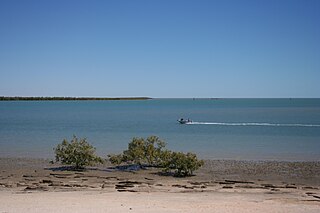
Karumba is a town and a coastal locality in the Shire of Carpentaria, Queensland, Australia. In the 2021 census, the locality of Karumba had a population of 487 people.

The Shire of Cloncurry is a local government area in North West Queensland, Australia. It covers an area of 47,971 square kilometres (18,521.7 sq mi), and has existed as a local government entity since 1884. The major town and administrative centre of the shire is Cloncurry.
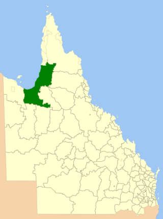
The Shire of Carpentaria is a local government area in Far North Queensland, Australia on the Gulf of Carpentaria, for which it is named.

The Shire of Burke is a local government area in North West Queensland, Australia. The shire lies on the south coast of the Gulf of Carpentaria and abuts the border with the Northern Territory. It covers an area of 39,864 square kilometres (15,391.6 sq mi), and has existed as a local government entity since 1885. The major town and administrative centre of the shire is Burketown.
The United pastoral districts of Moreton, Wide Bay, Burnett and Maranoa, and from 1857 Moreton, Wide Bay, Burnett, Maranoa, Leichhardt and Port Curtis, was an electoral district of the Legislative Assembly in the Australian state of New South Wales created in 1856 and consisted of the pastoral districts around the early settlements of Moreton Bay; Wide Bay, near Maryborough; the Burnett River, near Bundaberg; and the Maranoa region of South-western Queensland. In September 1856 the pastoral districts around the Leichhardt River in the Gulf of Carpentaria region and Port Curtis (Gladstone) were added to the electorate. The district was abolished for the 1859 election and replaced by the separate districts of East Moreton, West Moreton, Burnett and Leichhardt, while Maranoa became part of Darling Downs. All of these districts became part of Queensland when it was established as a separate colony in late 1859.
Leichhardt was an electoral district, located in the colony of New South Wales, Australia, and part of the New South Wales Legislative Assembly. The district was created for the July 1859 election, partly replacing the United Pastoral Districts of Moreton, Wide Bay, Burnett, Maranoa, Leichhardt and Port Curtis in the present day central Queensland. It included the towns of Rockhampton and Emerald, the pastoral districts around the Leichhardt River in the Gulf of Carpentaria region and Port Curtis (Gladstone). It was abolished in December 1859 as a result of the separation of Queensland.

The Aboriginal Shire of Kowanyama is a special local government area which is located on western Cape York Peninsula in Queensland, Australia. It is managed under a Deed of Grant in Trust under the Local Government Act 2004.
The Anglican Diocese of Carpentaria was an Anglican diocese in northern Australia from 1900 to 1996. It included most of northern Queensland, the islands of the Torres Strait and, until 1968, all of the Northern Territory. The see was based at Quetta Cathedral on Thursday Island in the Torres Strait.
The 1912 state election in Queensland, Australia was held on 27 April 1912.
The electoral district of Flinders was an electoral district of the Legislative Assembly in the Australian state of Queensland.
Burke was an electoral district of the Legislative Assembly in the Australian state of Queensland from 1873 to 1932, and again from 1960 to 1972. It covered remote rural areas in Northwest Queensland.
The Town of Normanton is a former local government area for the town of Normanton in North Queensland, Australia. It existed from 1886 to 1910.
Carpentaria was a Legislative Assembly electorate in the state of Queensland, Australia.

Commonwealth Lightship 4 (CLS4) Carpentaria is a lightship that was in service from 1917 to 1985 with the Commonwealth Lighthouse Service, built at the Cockatoo Island Dockyard and commissioned in 1917. The vessel is named after the Gulf of Carpentaria, where it spent most of its service life together with its sister ship CLS2.

Traeger is an electoral district of the Legislative Assembly in the Australian state of Queensland. It was created in the 2017 redistribution, and was named after Alfred Traeger, inventor of the pedal-powered radio, which was a significant contribution to people living in remote and rural communities in Queensland, such as those within Traeger.

Carpentaria is a coastal locality in the Shire of Carpentaria, Queensland, Australia. In the 2021 census, Carpentaria had a population of 25 people.
References
- ↑ "Register of Members of the Queensland Legislative Assembly" (PDF). Queensland Parliament. Retrieved 25 October 2016.