
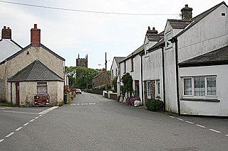
Ellenglaze (Cornish : Heylynlas) is a hamlet near the village of Cubert north of Perranporth in Cornwall, England. [1] It lies close to the edge of Penhale Sands (dunes).
Ellenglaze (Cornish : Heylynlas) is a hamlet near the village of Cubert north of Perranporth in Cornwall, England. [1] It lies close to the edge of Penhale Sands (dunes).
The manor of Ellenglaze is recorded in the Domesday Book as "Elil" (the 'glaze' was likely added later, from Cornish glas, meaning blue or green) and belonging to the monastery of Bodmin and having 2 hides of land and land for 8 ploughs. The monastery had 4 ploughs and 4 serfs there. There were also 8 villeins, 8 smallholders, half a square league of pasture and 20 sheep. The value of it was £1 sterling. [2] "Elil" was at one time identified with a place in the hundred of East Wivelshire. [3] It is the location of a former lead mine, abandoned in 1839. [4]
Ellenglaze Manor is a Grade II listed building, probably dating from the mid-late 17th century, with later alterations. [5]

Bodmin is a town and civil parish in Cornwall, England, United Kingdom. It is situated south-west of Bodmin Moor.

Callington is a civil parish and town in east Cornwall, England, United Kingdom about 7 miles (11 km) north of Saltash and 9 miles (14 km) south of Launceston.

Davidstow is a civil parish and village in north Cornwall, England, United Kingdom. The village is north of Bodmin Moor straddling the A395 road about 3 miles (5 km) north of Camelford. The hamlets of Hallworthy, Hendraburnick, Tremail and Trewassa are in the parish. It was formerly known as Dewstow(e).

Ludgvan is a civil parish and village in Cornwall, England, UK, 2+1⁄2 miles (4 km) northeast of Penzance. Ludgvan village is split between Churchtown, on the hill, and Lower Quarter to the east, adjoining Crowlas. For the purposes of local government, Ludgvan elects a parish council every four years; the town elects a member to Cornwall Council under the Ludgvan division.

Boyton is a civil parish and village in Cornwall, England, United Kingdom. It is situated close to the River Tamar and the border with Devon about six miles (10 km) north of Launceston. According to the 2001 census it had a population of 378.This increased to 457 at the 2011 census.

Polyphant, recorded as Polefant c. 1170, is a village in east Cornwall, England, United Kingdom. It is north of the civil parish of Lewannick, five miles (8 km) west of the town of Launceston near the convergence of the River Inny and Penpont Water.

St Enoder is a civil parish and hamlet in Cornwall, England, United Kingdom. The hamlet is situated five miles (8 km) southeast of Newquay. There is an electoral ward bearing this name which includes St Columb Road. The population at the 2011 census was 4,563.

Treverbyn is a civil parish and village in mid-Cornwall, England, United Kingdom, lying north of St Austell.
St Newlyn East is a civil parish and village in Cornwall, England, United Kingdom. The village is approximately three miles (5 km) south of Newquay. The name St Newlyn East is locally abbreviated to Newlyn East and according to an anonymous historian writing in The Cornishman in 1880 it was only in recent years that Saint had been added to the parish name.

Cubert is a village in Cornwall, England, United Kingdom. It is three miles (5 km) south-southwest of Newquay and is in the civil parish of Cubert.

Cardinham is a civil parish and a village in mid Cornwall, England. The village is approximately three-and-a-half miles (6 km) east-northeast of Bodmin. The hamlets of Fletchersbridge, Millpool, Milltown, Mount, Old Cardinham Castle and Welltown are in the parish.
Lanescot is a village in Cornwall, England, United Kingdom. It is in a former mining area, about four miles (6 km) east-northeast of St Austell and four miles (6 km) west-northwest of Fowey. The Saints' Way long-distance footpath passes through Lanescot.
Burniere is a settlement near Bodieve on the outskirts of Wadebridge in north Cornwall, England, United Kingdom.

Helstone is a hamlet in north Cornwall, England, United Kingdom. It is situated two miles (3 km) southwest of Camelford on the A39 road.

Trewint is a hamlet in the civil parish of Altarnun, east Cornwall, England, United Kingdom. The hamlet is just off the A30 main road, and is south of the village of Altarnun. Trewint Downs, part of Bodmin Moor, are further west.

Callestick is a hamlet in Cornwall, England, UK. It is 5 miles (8.0 km) north-west from Truro and about 1 mile (1.6 km) south of Perranzabuloe. Little Callestick lies to the northeast, near Chyverton House. The name Callestick comes from the Cornish language roots kell "cell" and Estek, a personal name.

Penpoll is a farm in the parish of Quethiock, Cornwall, England, UK. It is near the hamlet of Blunts and north of Tideford Cross. The meaning of Penpoll is "head of a creek".

Tolcarne is the name of a number of places in Cornwall, United Kingdom. The name Tolcarne is derived from Cornish Talkarn i.e. "hill-brow tor". A carn is a pile of stones and is the same as tor in Devon.
Trebartha is a hamlet in the civil parish of North Hill, in Cornwall, England, United Kingdom, and in the valley of the River Lynher.

Trenance is a hamlet adjoining Mawgan Porth in Cornwall, England, United Kingdom. Trenance Point is a headland nearby.
| Unitary authorities | |
|---|---|
| Major settlements (cities in italics) |
|
| Rivers | |
| Topics | |