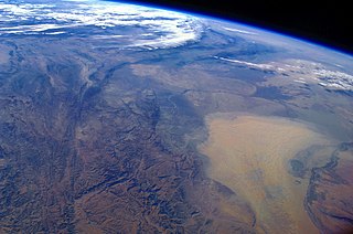
Turkmenistan is a landlocked country in Central Asia, bordering the Caspian Sea to the west, Iran and Afghanistan to the south, Uzbekistan to the north-east, and Kazakhstan to the north-west. It is the southernmost republic of the Commonwealth of Independent States (CIS), the loose federation created at the end of 1991 by most of the Post-Soviet states.

Atyrau, known until 1991 as Guryev, is a city in Kazakhstan and the capital of Atyrau Region. Atyrau is a transcontinental city, at the mouth of the Ural River on the Caspian Sea, between Europe and Asia, 2,700 kilometres west of Almaty and 351 kilometres east of the Russian city of Astrakhan.
Balkan Region is the westernmost of the five regions of Turkmenistan. Clockwise from north it borders Kazakhstan, Uzbekistan (north); two provinces of Turkmenistan (east), Iran (south), and the Caspian Sea (west). The capital city is Balkanabat, formerly known as Nebit Dag. The region's boundaries are identical to those of the former Krasnovodsk Oblast', a Soviet-era province of the Turkmen Soviet Socialist Republic with its capital in the city of Krasnovodsk. This oblast was liquidated and restored repeatedly in the 20th century, concluding with its abolition in 1988. However, the administrative boundaries of the region were restored in 1991 when Balkan Region was established with its capital being moved to Nebit Dag which was later renamed Balkanabat.

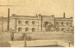
Türkmenbaşy, formerly known as Krasnovodsk, Kyzyl-Su, and Shagadam, is a city in Balkan Province in western Turkmenistan, on the Türkmenbaşy Gulf of the Caspian Sea. It sits at an elevation of 27 metres. The population was 86,800, mostly ethnic Turkmens but also Russian, Armenian and Azeri minorities. As the terminus of the Trans-Caspian Railway and site of a major seaport on the Caspian, it is an important transportation center. The city is also the site of Turkmenistan's largest oil refining complex.

Türkmenabat, formerly Amul, Cärjew/Chardzhou, and Novy Chardzhuy, is the second-largest city in Turkmenistan and the administrative centre of Lebap Province. As of 2009, it had a population of approximately 254,000 people. From 1924 to 1927, it was also named Leninsk in honor of Vladimir Lenin.

Tejen is an oasis city in the Karakum Desert, in Ahal Province of Turkmenistan. It lies along the M37 highway, between Dushak and Mary, 223 kilometres (139 mi) by road southeast of Ashgabat. It has a population of approximately 52,000. To the east is the larger oasis of Mary. Khlopin suggests Tejen may have been the birthplace of Zoroaster.

Balkanabat, formerly Nebit-Dag and Neftedag, is the administrative centre of Balkan Province, the largest province in Turkmenistan. It lies at the foot of the Balkan Daglary mountain range. Balkanabat is about 450 km west of Ashgabat and 160 km east of the seaport city of Türkmenbaşy. The city layout is a grid of apartment blocks called kvartal (quarters). The main streets are Magtymguly, Pervomayskiy and Gurbansoltan eje şaýoly.
Daşoguz, formerly known as Tashauz and Dashkhovuz, is a city in northern Turkmenistan and the capital of Daşoguz Province. The Uzbekistan border is about 10 km away.

Serhetabat is a city in Tagtabazar District, Mary Province, Turkmenistan. Serhetabat lies in the valley of the Kushk River. The population was 5,200 in 1991. It is immediately opposite Torghundi, Afghanistan, with which it is connected by a road and a 1,520 mm gauge railway.
Gyzylarbat is a city subordinate to a district in Turkmenistan, located north-west of the capital, Ashgabat on the M37 highway to the Caspian Sea. The population of Gyzylarbat is 50,000 people, mainly Turkmen. The main language spoken in the region is Turkmen. It is near the northwest end of the line of oases on the north slope of the Kopet Dag that extends southeast to Ashgabat.
Garabogaz is a city subordinate to Turkmenbashy District, Balkan province, Turkmenistan, on the shore of the Caspian Sea. Until 2002, the municipality had the status of a town and was named Bekdaş.
Sarahs is an oasis city in Ahal Province, Turkmenistan, and the administrative center of Sarahs district. It is located at latitude 36°31' North; longitude 61°12' East and an elevation of 285m above sea level. It is one of the oases of the ancient Silk Road lying between Merv to the east and Mashhad to the west. In 1989 the city had a population of 9,585.

Kerki is a city in and capital of Kerki District, Lebap Province, Turkmenistan. It was formerly known as Zamm and, between 1999 and 2017, as Atamyrat.

Bereket, formerly Gazanjyk or Kazandzhik, is a city in Balkan Province in western Turkmenistan. Bereket is the administrative centre of Bereket District.
Esenguly District is a district of Balkan Province in Turkmenistan. The administrative center of the district is the town of Esenguly
Köýtendag is a city and the administrative center of Köýtendag District in Lebap Province, Turkmenistan. On 29 December 1999, by Parliamentary Resolution No. HM-61, the city and district of Çarşangy were renamed Köýtendag. On 27 July 2016, by Parliamentary Resolution No. 425-V the town of Köýtendag was upgraded in status to "city in a district".
Baýramaly is a city in and the seat of Baýramaly District, Mary Province, Turkmenistan. It lies about 27 km east of the provincial capital Mary, along the main railway line from Ashgabat to Tashkent. In 2009, its population was estimated at 88,486.
Amu Dar'ya is a town in Köýtendag District, Lebap Province, Turkmenistan, on the river of the same name opposite the town of Kerki. As of 1989, it had a population of 5,018.

Aktau ) is a city in south-west Kazakhstan, located on the eastern shore of the Caspian Sea. Its name means 'white mountain' in the Kazakh language, which may be due to its cliffs that overlook the Caspian. From 1964 to 1991, the city was named Shevchenko, in honor of the Ukrainian poet Taras Shevchenko, who was exiled to the area during his lifetime. Aktau is located on the Mangyshlak Peninsula and serves as the administrative center of the Mangystau Region.

The Iran–Turkmenistan border is the national border separating the countries of Iran and Turkmenistan. It is 1,148 km in length and runs from the Caspian Sea to the tripoint with Afghanistan. The Turkmen capital Ashgabat is only 15 miles north of this boundary, and Mashhad is 47 miles south of it.
