The economy of Turkmenistan continues to recover from the 2014 downturn in hydrocarbon prices, but remains "in the grip of its worst economic crisis since the immediate post-independence period, driven in part by low gas prices, the suspension of gas exports to Russia between 2016 and 2019...and poor harvests." Former President Gurbanguly Berdimuhamedow at a session of the Cabinet of Ministers on March 11, 2021, called the rate of GDP growth unsatisfactory. When discussing the 2021 government budget, he noted that 2021 would be "as difficult" a year as 2020 had been.

Ashgabat or Asgabat (Turkmen: Aşgabat, [ɑʃʁɑˈbɑt]; Persian: عشقآباد, romanized: Ešqābād, formerly named Poltoratsk between 1919 and 1927, is the capital and the largest city of Turkmenistan. It lies between the Karakum Desert and the Kopetdag mountain range in Central Asia, near the Iran-Turkmenistan border.

Turkmenistan is a landlocked country located in Central Asia, bordered by Kazakhstan to the northwest, Uzbekistan to the north, east and northeast, Afghanistan to the southeast, Iran to the south and southwest and the Caspian Sea to the west. Ashgabat is the capital and largest city. The population is about 6 million, the lowest of the Central Asian republics, and Turkmenistan is one of the most sparsely populated nations in Asia.

Ahal Region is one of five provinces of Turkmenistan. It is in the south-center of the country, bordering Iran and Afghanistan along the Kopet Dag Range. Its area is 97,160 km2 (37,510 sq mi) and population 939,700.

Lebap Region is one of the regions of Turkmenistan. It is in the northeast of the country, bordering Afghanistan, Uzbekistan along the Amu Darya. Its capital is Türkmenabat. It has an area of 93,727 square kilometers, and a population of 1,334,500 people.

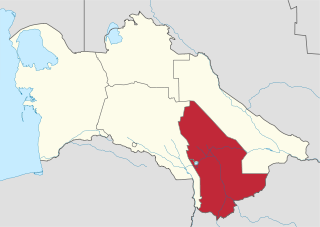
Mary Region is one of five provinces in Turkmenistan. It is located in the south-east of the country, bordering Afghanistan. Its capital is the city of Mary. Its area is 87,150 km2 (33,650 sq mi) and population 1,480,400. The average population density is about 15 persons per square kilometer, but it reaches 150–200 per square kilometer in the most developed oases.

Magtymguly Pyragy, born Magtymguly, was a Turkmen spiritual leader, philosophical poet, Sufi and traveller who is considered to be the most famous figure in Turkmen literary history.
Mary, formerly named Merv, Meru and Alexandria Margiana, is a city on an oasis in the Karakum Desert in Turkmenistan, located on the Murgab River. It is the capital city of Mary Region. In 2010, Mary had a population of 126,000, up from 92,000 in the 1989 census. The ruins of the ancient city of Merv are located near the present-day city.

Muhammetnazar Gapurowiç Gapurow was a Turkmen politician who has served as the first secretary of the Communist Party of the Turkmen SSR from 1969 until 1985. He spent his entire career in the Komsomol and Communist Party apparatus, becoming the republic's most influential politician for almost two decades in the Brezhnev era.

The districts of Turkmenistan are territorial entities below the provinces of Turkmenistan. They may be counties, cities, or boroughs of cities. The heads of the districts are appointed by the President of Turkmenistan.

Darvaza is a rural council in Ak bugdaý District, Ahal Province, Turkmenistan of about 350 inhabitants, located in the middle of the Karakum Desert, about 260 km north of Ashgabat. The rural council consists of three separate villages: Derweze, Ataguýy, and Böri.

Saparmyrat Ataýewiç Nyýazow, also known as Türkmenbaşy, lit. 'head of the Turkmen', was a Turkmen politician who ruled Turkmenistan as a dictator from 1985 until his death in 2006. He was first secretary of the Turkmen Communist Party from 1985 until 1991 and supported the 1991 Soviet coup attempt. He continued to rule Turkmenistan for 15 years after independence from the Soviet Union in 1991.
Gökdepe District is a district of Ahal Region, Turkmenistan.
Mangʻit is the seat of Amudaryo District in the autonomous republic of Karakalpakstan within Uzbekistan. It is located on the border with Turkmenistan, about 10 kilometres (6 mi) northeast of the Turkmen town of Gubadag and about 10 kilometres (6 mi) west of the Amu Darya river. It is 50 kilometres (31 mi) southeast of Nukus, the Karakalpak capital. Its population is 33,200 (2016).

Köýtendag District is a district of Lebap Province in Turkmenistan. The administrative center of the district is the city of Köýtendag.
Andalyp, until 2004 called Ýylanly, and from 2004 to 2022 called Gurbansoltan eje adyndaky, is a city and capital of Akdepe District in Daşoguz Province, Turkmenistan.
Khajeh is a city in Khvajeh District of Heris County, East Azerbaijan province, Iran. At the 2006 census, its population was 3,700 in 981 households. The following census in 2011 counted 3,801 people in 1,154 households. The latest census in 2016 showed a population of 4,011 people in 1,265 households.
Gökdepe, also Geok Tepe, is a city in and the administrative center of Gökdepe District, Ahal Region, Turkmenistan, 45 kilometres (28 mi) north-west of Ashgabat. The city is built around a former fortress of the Turkmens which bore the same name. The city lies along the M37 highway and the Trans-Caspian Railway.

Bayat is one of the Oghuz tribes in Turkmenistan, Iran, Turkey, Azerbaijan, Iraq, Afghanistan, and Syria. When Oghuz Turks started to migrate from the Aral steppes to Khorasan in the 11th and 13th centuries, Bayat people spread throughout the region. They are sub-ethnic groups of Turkmens and Azerbaijanis. Bayats are Muslim and speak a southern dialect of Azerbaijani language in Azerbaijan and Iran, or their own dialect of Turkish in Turkey, and Ersari dialect of Turkmen in Turkmenistan and Uzbekistan. The ancient Turkmen proverb says: "Kayi and Bayat tribes shall lead the people".


