This article needs additional citations for verification .(October 2007) |
The ethno-linguistic composition of Austria-Hungary according to the census of 31 December 1910 was as follows: [1]
This article needs additional citations for verification .(October 2007) |
The ethno-linguistic composition of Austria-Hungary according to the census of 31 December 1910 was as follows: [1]


| Area | Number | % |
|---|---|---|
| Cisleithania [2] | 28,571,934 | 55.6 |
| Transleithania [3] | 20,886,487 | 40.6 |
| Bosnia and Herzegovina (Austro-Hungarian condominium) | 1,931,802 | 3.8 |
| Total | 51,390,223 | 100.0 |
| Rank | Current English name | Contemporary official name [6] | Other | Present-day country | Population in 1910 | Present-day population |
|---|---|---|---|---|---|---|
| 1. | Vienna | Wien | Bécs, Beč, Dunaj | Austria | 2,031,498 (city without the suburb 1,481,970) | 1,840,573 (Metro: 2,600,000) |
| 2. | Prague | Prag, Praha | Prága | Czech Republic | 668,000 (city without the suburb 223,741) | 1,301,132 (Metro: 2,620,000) |
| 3. | Trieste | Triest | Trieszt, Trst | Italy | 229,510 | 204,420 |
| 4. | Lviv | Lemberg, Lwów | Ilyvó, Львів, Lvov, Львов | Ukraine | 206,113 | 728,545 |
| 5. | Kraków | Krakau, Kraków | Krakkó, Krakov | Poland | 151,886 | 762,508 |
| 6. | Graz | Grác, Gradec | Austria | 151,781 | 328,276 | |
| 7. | Brno | Brünn, Brno | Berén, Börön, Börénvásár | Czech Republic | 125,737 | 377,028 |
| 8. | Chernivtsi | Czernowitz | Csernyivci, Cernăuți, Чернівці | Ukraine | 87,128 | 242,300 |
| 9. | Plzeň | Pilsen, Plzeň | Pilzen | Czech Republic | 80,343 | 169,858 |
| 10. | Linz | Linec | Austria | 67,817 | 200,841 |
| Rank | Current English name | Contemporary official name [6] | Other | Present-day country | Population in 1910 | Present-day population |
|---|---|---|---|---|---|---|
| 1. | Budapest | Budimpešta | Hungary | 1,232,026 (city without the suburb 880,371) | 1,735,711 (Metro: 3,303,786) | |
| 2. | Szeged | Szegedin, Segedin | Hungary | 118,328 | 170,285 | |
| 3. | Subotica | Szabadka | Суботица | Serbia | 94,610 | 105,681 |
| 4. | Debrecen | Hungary | 92,729 | 208,016 | ||
| 5. | Zagreb | Zágráb, Agram | Croatia | 79,038 | 803,000 (Metro: 1,228,941) | |
| 6. | Bratislava | Pozsony | Pressburg, Prešporok | Slovakia | 78,223 | 425,167 |
| 7. | Timișoara | Temesvár | Temeswar | Romania | 72,555 | 319,279 |
| 8. | Kecskemét | Hungary | 66,834 | 111,411 | ||
| 9. | Oradea | Nagyvárad | Großwardein | Romania | 64,169 | 196,367 |
| 10. | Arad | Arad | Romania | 63,166 | 159,074 | |
| 11. | Hódmezővásárhely | Hungary | 62,445 | 46,047 | ||
| 12. | Cluj-Napoca | Kolozsvár | Klausenburg | Romania | 60,808 | 324,576 |
| 13. | Újpest | Hungary | 55,197 | 100,694 | ||
| 14. | Miskolc | Hungary | 51,459 | 157,177 | ||
| 15. | Pécs | Hungary | 49,852 | 145,347 | ||


In the Austrian Empire (Cisleithania), the census of 1911 recorded Umgangssprache, everyday language. Jews and those using German in offices often stated German as their Umgangssprache, even when having a different Muttersprache. The Istro-Romanians were counted as Romanians.
In the Kingdom of Hungary (Transleithania), the 1910 census was based on mother tongue. [7] [8] [9] [10] According to the census, 54.4% of the inhabitants of Hungary were recorded to speak Hungarian as their native language. [7] This number included the Jewish ethnic group (around 5% of the population [11] ) who were overwhelmingly Hungarian-speaking (the Jews tending to declare German as mother tongue due to the immigration of Jews of Yiddish/German mother tongue). [12]
| Language | Number | % |
|---|---|---|
| German | 12,006,521 | 23.36 |
| Hungarian | 10,056,315 | 19.57 |
| Czech | 6,442,133 | 12.54 |
| Serbo-Croatian | 5,621,797 | 10.94 |
| Polish | 4,976,804 | 9.68 |
| Ruthenian | 3,997,831 | 7.78 |
| Romanian | 3,224,147 | 6.27 |
| Slovak | 1,967,970 | 3.83 |
| Slovene | 1,255,620 | 2.44 |
| Italian | 768,422 | 1.50 |
| Other | 1,072,663 | 2.09 |
| Total | 51,390,223 | 100.00 |
| Land | Main language | Others (if more than 2%) |
|---|---|---|
| Bohemia | Czech (63.2%) | German (36.8%) |
| Dalmatia | Serbo-Croatian (94.6%) | Italian (2.8%) |
| Galicia | Polish (58.6%) | Ruthenian (40.2%) |
| Lower Austria | German (95.9%) | Czech (3.8%) |
| Upper Austria | German (99.7%) | |
| Bukovina | Ruthenian (38.4%) | Romanian (34.4%), German (21.2%), Polish (4.6%) |
| Carinthia | German (78.6%) | Slovenian (20.7%) |
| Carniola | Slovenian (94.4%) | German (4.9%) |
| Salzburg | German (99.7%) | |
| Austrian Silesia | German (43.9%) | Polish (31.7%), Czech (24.3%) |
| Styria | German (70.5%) | Slovenian (28.4%) |
| Moravia | Czech (71.8%) | German (27.6%) |
| County of Tyrol | German (57.3%) | Italian (42.1%) |
| Austrian Littoral | Italian (39.6%) | Slovenian (29.5%), Serbo-Croatian (18.8%), German (3.1%) |
| Vorarlberg | German (95.4%) | Italian (4.4%) |


| Land | Mother tongues (1910 census) [7] [13] |
|---|---|
| Kingdom of Hungary | Hungarian (54.4%), Romanian (16.1%), Slovak (10.7%), German (10.4%), Ruthenian (2.5%), Serbian (2.5%), Croatian (1.8%) |
| Kingdom of Croatia-Slavonia | Croatian (62.5%), Serbian (24.6%), German (5.0%), Hungarian (4.1%) |
| Land | Hungarian | Romanian | German | Slovak | Croatian | Serbian | Ruthenian | Other | Total |
|---|---|---|---|---|---|---|---|---|---|
| Danube Right Bank | 72% (2,221,295) | 0% (833) | 18% (555,694) | 0.6% (17,188) | 5.5% (168,436) | 0.5% (15,170) | 0% (232) | 3.4% (105,556) | 14.8% (3,084,404) |
| Danube Left Bank | 32.7% (711,654) | 0% (704) | 6.6% (144,395) | 58.8% (1,279,574) | 0.1% (2,294) | 0% (200) | 0% (393) | 1.7% (36,710) | 10.4% (2,175,924) |
| Danube-Tisza | 81.2% (3,061,066) | 0.1% (4,813) | 9.5% (357,822) | 2.1% (79,354) | 0.1% (4,866) | 4.1% (154,298) | 0.3% (11,121) | 4.1% (96,318) | 18% (3,769,658) |
| Tisza Right Bank | 53.5% (945,990) | 0.1% (1,910) | 5.6% (98,564) | 25% (441,776) | 0% (486) | 0% (247) | 14.3% (253,062) | 1.6% (27,646) | 8.5% (1,769,681) |
| Tisza Left Bank | 61.8% (1,603,924) | 24% (621,918) | 3.2% (83,229) | 3.1% (81,154) | 0% (327) | 0% (321) | 7.5% (194,504) | 0.3% (8,547) | 12.4% (2,594,924) |
| Tisza-Maros | 22.2% (474,988) | 39.5% (845,850) | 19.9% (427,253) | 2.1% (44,715) | 0.2% (4,950) | 13.6% (290,434) | 0.1% (3,188) | 2.4% (50,391) | 10.3% (2,141,769) |
| Transylvania | 34.3% (918,217) | 55% (1,472,021) | 8.7% (234,085) | 0.1% (2,404) | 0% (523) | 0% (421) | 0.1% (1,759) | 1.8% (48,937) | 12.8% (2,678,367) |
| Fiume | 13% (6,493) | 0.3% (137) | 4.6% (2,315) | 0.4% (192) | 26% (12,926) | 0.9% (425) | 0% (11) | 54.8 (27,307, mostly Italian) | 0.2% (49,806) |
| Croatia-Slavonia | 4% (105,948) | 0% (846) | 5.1% (134,078) | 0.8% (21,613) | 62.5% (1,638,354) | 24.6% (644,955) | 0.3% (8,317) | 2.6% (67,843) | 12.6% (2,621,954) |
| Total | 48.1% (10,050,575) | 14.1% (2,949,032) | 9.8% (2,037,435) | 9.4% (1,967,970) | 8.8% (1,833,162) | 5.3% (1,106,471) | 2.3% (472,587) | 2.2% (469,255) | 100% (20,886,487) |
| Region | Mother Tongues | Hungarian language | Other languages |
|---|---|---|---|
| Transylvania | Romanian – 2,819,467 (54%) | 1,658,045 (31.7%) | German – 550,964 (10.5%) |
| Upper Hungary | Slovak – 1,688,413 (57.9%) | 881,320 (30.2%) | German – 198,405 (6.8%) |
| Délvidék | Serbo-Croatian – 601,770 (39.8%) | 425,672 (28.1%) | German – 324,017 (21.4%) Romanian – 75,318 (5.0%) Slovak – 56,690 (3.7%) |
| Transcarpathia | Ruthenian – 330,010 (54.5%) | 185,433 (30.6%) | German – 64,257 (10.6%) |
| Fiume | Italian – 24,212 (48.6%) | 6,493 (13%) | Serbo-Croatian – 13,351 (26.8%) Slovene - 2,336 (4.7%) German - 2,315 (4.6%) |
| Őrvidék | German – 217,072 (74.4%) | 26,225 (9%) | Croatian – 43,633 (15%) |
| Muravidék | Slovene – 74,199 (80.4%) – in 1921 | 14,065 (15.2%) – in 1921 | German – 2,540 (2.8%) – in 1921 |
The Germans in Croatia were mainly living in the eastern parts of the country where they had been settled along the Drava and Danube rivers, and the former Military Frontier (Militärgrenze), after the Habsburg (re)conquest of the area from the Ottomans in 1687.

| Religions/Confessions | in all of Austria-Hungary | Austrian part | Hungarian part | Bosnia and Herzegovina |
|---|---|---|---|---|
| Catholics | 76.6% | 90.9% | 61.8% | 22.9% |
| Protestants | 8.9% | 2.1% | 19% | 0.3% |
| Orthodox | 8.7% | 2.3% | 14.3% | 43.5% |
| Jews | 4.4% | 4.7% | 4.9% | 0.6% |
| Muslims | 1.3% | 0% | 0% | 32.7% |
The ethnic groups of the Austro-Hungarian empire subdivided according to their own sub-ethnic groups and regions they inhabited: [14]
The ethnic germans of the Austro-Hungarian empire spoked a variety of dialects, which the following were spoken in the empire:
The Czechs inhabited the three traditional Czech lands of Bohemia (Čechy), Moravia (Morava) and Silesia (Slezsko), which had their own traditional ethnographical Czech groups (Moravians, Silesians). Further sub-ethnic groups of the Moravians included the Horáci, the Hanáki and the Moravian Wallachians.
Lower Austria was home to a significant Czech population; especially in the capital, Vienna. There was also significant Czech settlements in Galicia and Slavonia (Czechs in Croatia).
The inhabitants of the Moravian Slovakia region (in current-day Czechia) were considered in the 19th century as linguistically, speakers of the Czech language, but ethnically belonging to the Slovak ethnicity.
There were Slovak diaspora communnities in Austria, Hungary proper, Voivodina, Slavonia, Banat and Crișana.
Subgroups of the Polish population:
Ethnographical groups associated or considered part of the Ukrainian ethnic group in the 19th century included:
{{cite book}}: ISBN / Date incompatibility (help)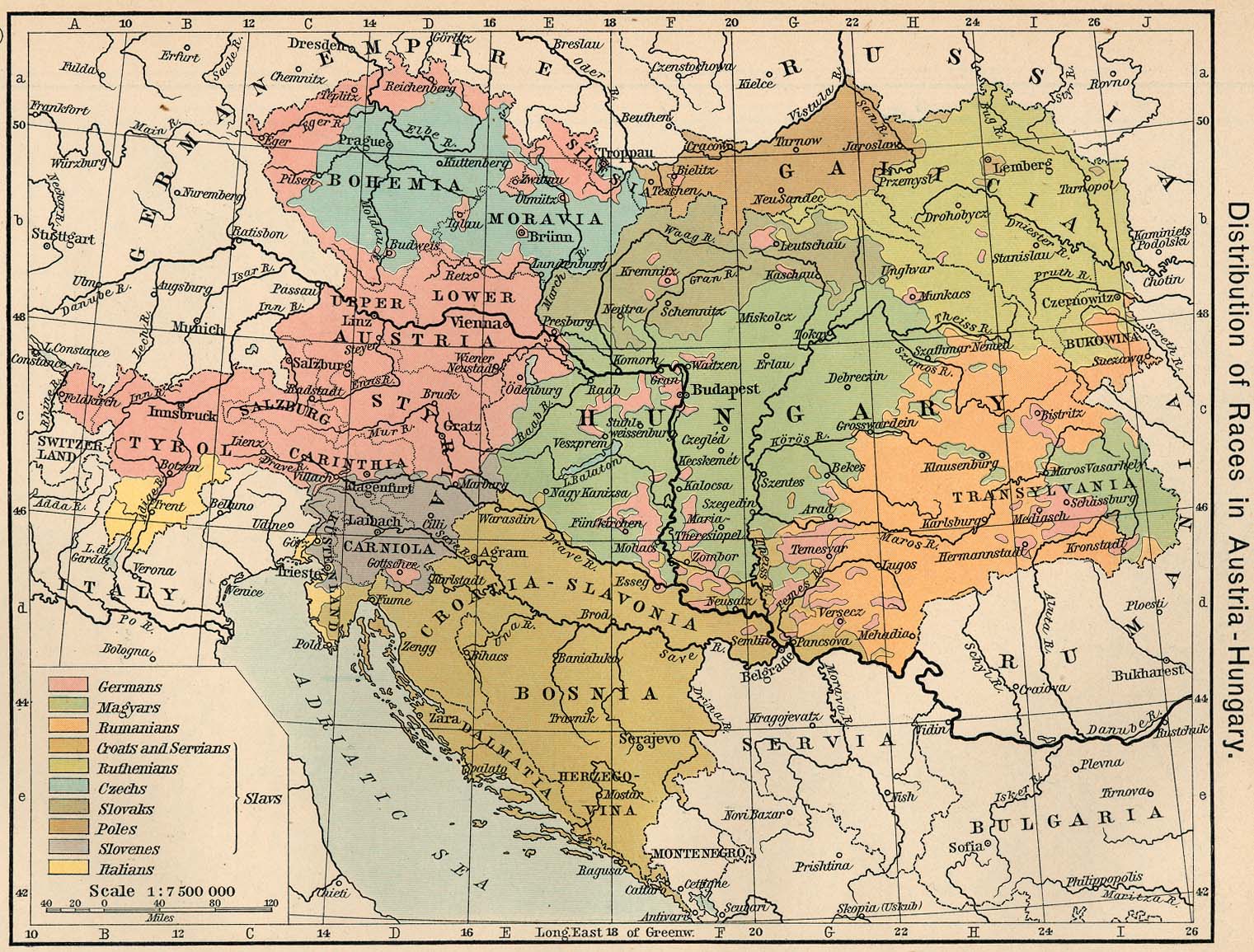