
Montgomery County is a rural county located in the southern Piedmont of the U.S. state of North Carolina. As of the 2020 census, the population was 25,751. Its county seat is Troy.
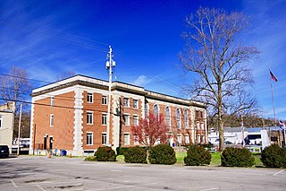
Cocke County is a county on the eastern border of the U.S. state of Tennessee. As of the 2020 census, the population was 35,999. Its county seat is Newport. Cocke County comprises the Newport, TN Micropolitan Statistical Area, which is part of the Knoxville-Morristown-Sevierville, Tennessee Combined Statistical Area.

Oconee County is the westernmost county in the U.S. state of South Carolina. As of the 2020 census, the population was 78,607. Its county seat is Walhalla and its largest community is Seneca. Oconee County is included in the Seneca, SC Micropolitan Statistical Area, which is also included in the Greenville-Spartanburg-Anderson, SC Combined Statistical Area. South Carolina Highway 11, the Cherokee Foothills National Scenic Highway, begins in southern Oconee County at Interstate Highway 85 at the Georgia state line.

Union County is a county located in the U.S. state of North Carolina. As of the 2020 census, the population was 238,267. Its county seat is Monroe. Union County is included in the Charlotte-Concord-Gastonia, NC-SC Metropolitan Statistical Area.

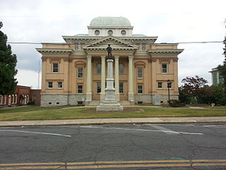
Stanly County is a county in the U.S. state of North Carolina. As of the 2020 census, the population was 62,504. Its county seat is Albemarle.
Randolph County is a county located in the U.S. state of North Carolina. As of the 2020 census, the population was 144,171. Its county seat is Asheboro.
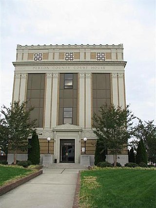
Person County is a county located in the U.S. state of North Carolina. The population was 39,097 as of the 2020 census. The county seat is Roxboro.

Jackson County is a county located in the western part of the U.S. state of North Carolina. As of the 2020 census, the population was 43,109. Since 1913, its county seat has been Sylva, which replaced Webster. Cullowhee is the site of Western Carolina University (WCU). In the early 21st century, the university has more than 12,000 students, nearly twice the number of permanent residents of Cullowhee. The university has a strong influence in the region and county. More than 10 percent of the county residents identify as Native American, mostly Cherokee. The federally recognized Eastern Band of Cherokee Indians is based at Qualla Boundary, land that consists of territory in both Jackson and neighboring Swain County. This is the only federally recognized tribe in North Carolina, and one among three federally recognized Cherokee tribes nationally. The other two are based in what is now the state of Oklahoma, a former Indian Territory.

Davidson County is a county located in the U.S. state of North Carolina. As of the 2020 census, the population was 168,930. Its county seat is Lexington, and its largest community is Thomasville.

Fairview is a census-designated place (CDP) in Buncombe County, North Carolina, United States. The population was 2,678 at the 2010 census. It is part of the Asheville Metropolitan Statistical Area.

Swannanoa is a census-designated place (CDP) in Buncombe County, North Carolina, United States. The population 5,021 at the 2020 census up from 4,576 at the 2010 census. The community is named for the Swannanoa River, which flows through the settlement. It is part of the Asheville Metropolitan Statistical Area.

Cajah's Mountain is a town in Caldwell County, North Carolina, United States. The population was 2,823 at the 2010 census. It is part of the Hickory–Lenoir–Morganton Metropolitan Statistical Area.
Biscoe is a town in Montgomery County, North Carolina, United States. The population was 1,700 at the 2010 census. The town is named after Henry Biscoe, an important customer of the local lumber business.
Troy is a town in Montgomery County, North Carolina, United States. The population was 3,188 at the 2010 census. It is the county seat of Montgomery County. A short story by Charles W. Chesnutt, The Sheriff's Children, is set in Troy.

Asheboro is a city in and the county seat of Randolph County, North Carolina, United States. The population was 27,156 at the 2020 census. It is part of the Greensboro-High Point Metropolitan Area of the Piedmont Triad and is home of the state-owned North Carolina Zoo.

Albemarle is a city in and the county seat of Stanly County, North Carolina, United States. The population was 16,432 in the 2020 census.

Indian Trail is a suburban town in Union County, North Carolina, United States. A part of the Charlotte metropolitan area, Indian Trail has grown rapidly in the 21st century, going from 1,942 residents in 1990 to 39,997 in 2020.

Unionville is a rural town in Union County, North Carolina, United States. The population was 6,643 at the 2020 census.

Fairview is a town in Collin County, Texas, United States. It is part of the Dallas-Fort Worth metropolitan area. As of the 2017 census, the town population was 8,950. The estimated population in 2018 was 9,092. The town is adjacent to the 289-acre (1.17 km2) Heard Natural Science Museum and Wildlife Sanctuary.

Fountain Inn is a city in Greenville and Laurens counties in the U.S. state of South Carolina. The population was 10,416 at the 2020 census, up from 7,799 in 2010. It is part of the Greenville-Mauldin-Easley Metropolitan Statistical Area.

