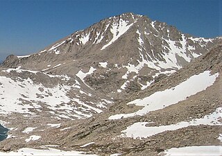
Mount Fiske is a 13,503-foot-elevation mountain summit located near the crest of the Sierra Nevada mountain range, in Fresno County of northern California, United States. It is situated in northern Kings Canyon National Park, 23 miles (37 km) west of the community of Big Pine, 0.83 miles (1.34 km) east of Mount Huxley, and two miles south of Mount Darwin, which is the nearest higher neighbor. Mount Fiske ranks as the 60th highest summit in California.

Black Giant is a 13,330-foot-elevation (4,060-meter) mountain summit located west of the crest of the Sierra Nevada mountain range, in Fresno County of central California, United States. Black Giant ranks as the 86th highest summit in California. It is the northernmost and highest summit on its namesake ridge, the Black Divide in northern Kings Canyon National Park. The peak is situated 3.9 miles (6.3 km) east of Mount Goddard, and 2.6 miles (4.2 km) south-southeast of Mount Fiske, which is the nearest higher neighbor. Topographic relief is significant as it rises 4,000 feet above Le Conte Canyon in approximately two miles. Muir Pass is 1.4 miles (2.3 km) to the northwest, and the approach to this remote peak is made via the John Muir Trail.

Mount Warlow is a 13,206-foot-elevation mountain summit located 1.5 miles (2.4 km) west of the crest of the Sierra Nevada mountain range, in Fresno County of northern California, United States. It is situated on the Goddard Divide in northern Kings Canyon National Park, 1.2 miles (1.9 km) north of Muir Pass, 0.69 miles (1.11 km) southeast of Mount Huxley, and 0.68 miles (1.09 km) southwest of Mount Fiske, which is the nearest higher neighbor. Mount Warlow ranks as the 108th highest summit in California. The approach to this remote peak is made via the John Muir Trail.

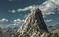
North Guard is a remote 13,327-foot-elevation (4,062-meter) mountain summit located near the northern end of the Great Western Divide of the Sierra Nevada mountain range, in Tulare County of northern California. It is situated in Kings Canyon National Park, 0.9 miles (1.4 km) southeast of Mount Farquhar, and 0.6 miles (0.97 km) north-northwest of Mount Brewer, which is the nearest higher neighbor. Topographic relief is significant as the east aspect rises 3,858 feet above East Lake in three miles. North Guard ranks as the 87th highest summit in California, and the second highest point of the northern Great Western Divide. It's not as high as Mount Brewer, but offers better climbing and is considered one of the classic climbing routes in the Sierra Nevada.

Black Mountain is a 13,291-foot-elevation (4,051-meter) mountain summit located on the crest of the Sierra Nevada mountain range in northern California. It is situated on the common border of Fresno County with Inyo County, as well as the shared boundary of John Muir Wilderness and Kings Canyon National Park. It is 10.5 miles (16.9 km) west of the community of Independence, and 4.3 miles (6.9 km) north-northwest of parent University Peak. Black Mountain ranks as the 91st highest summit in California. Topographic relief is significant as the west aspect rises 2,750 feet above Rae Lakes in approximately one mile. The John Muir Trail traverses below the west aspect of this peak, providing an approach to the mountain. The first ascent of the summit was made in 1905 by George R. Davis, a USGS topographer. This mountain is habitat for the endangered Sierra Nevada bighorn sheep, which restricts climbing from July through December, so most ascents are made in the spring.

Mount Rixford is a 12,887-foot-elevation (3,928-meter) mountain summit located one mile west of the crest of the Sierra Nevada mountain range, in the southeast corner of Fresno County, in northern California. It is situated in Kings Canyon National Park, 11.5 miles (18.5 km) west of the community of Independence, and one mile north of the Kearsarge Pinnacles and Kearsarge Lakes. Topographic relief is significant as the north aspect rises 2,346 feet above Rae Lakes in one mile. The John Muir Trail crosses Glen Pass one mile to the west of this mountain. Mt. Rixford ranks as the 183rd highest summit in California. Painted Lady is a subsidiary summit at the end of Rixford's north ridge.

Marion Peak is a remote 12,719-foot-elevation (3,877-meter) mountain summit located in Kings Canyon National Park, in Fresno County of northern California, United States. It is situated on Cirque Crest which is west of the crest of the Sierra Nevada mountain range, 2.13 miles (3.43 km) northeast of State Peak, and 2.6 miles (4.2 km) northwest of Arrow Peak, the nearest higher neighbor. Topographic relief is significant as the north aspect rises 2,400 feet above Marion Lake in one mile, and the southeast aspect rises 3,500 feet above South Fork Kings River in less than two miles.

Crater Mountain is a 12,874-foot-elevation (3,924-meter) mountain summit located west of the crest of the Sierra Nevada mountain range, in Fresno County of northern California, United States. It is situated in eastern Kings Canyon National Park, 15.5 miles (24.9 km) northwest of the community of Independence, one mile immediately southwest of Pinchot Pass, and 1.3 miles (2.1 km) southeast of Mount Ickes, which is the nearest higher neighbor. Other nearby peaks include Mount Wynne, 1.5 miles (2.4 km) to the northeast, and Mount Cedric Wright, 2.2 miles (3.5 km) to the southeast. Crater Mountain ranks as the 186th highest summit in California. Topographic relief is significant as the west aspect rises 2,000 feet in less than one mile. The approach to this remote peak is made via the John Muir Trail which passes below the east aspect of the mountain. The first ascent of the summit was made July 19, 1922, by W. H. Ink, Meyers Butte, Frank Baxter, and Captain Wallace. This mountain has no crater as the name implies.

Mount Perkins is a 12,566-foot-elevation mountain summit located on the crest of the Sierra Nevada mountain range in northern California. It is situated on the common border of Fresno County with Inyo County, as well as the boundary between John Muir Wilderness and Kings Canyon National Park. It is 13.5 miles (21.7 km) northwest of the community of Independence, 1.65 miles (2.66 km) north of Mount Cedric Wright, 2.2 miles (3.5 km) east of Crater Mountain, and 1.4 miles (2.3 km) southeast of Mount Wynne. Climbing routes to the summit include the west slope, and the north and south ridges. The John Muir Trail traverses below the west base of the peak on its descent south from Pinchot Pass, providing an approach to the mountain.
Mount Ickes is a 12,959-foot-elevation (3,950-meter) mountain summit located west of the crest of the Sierra Nevada mountain range, in Fresno County of northern California, United States. It is situated in eastern Kings Canyon National Park, 13.5 miles (21.7 km) northwest of the community of Independence, 1.5 mile west of Pinchot Pass, and 2 miles (3.2 km) west of Mount Wynne, which is the nearest higher neighbor. Other nearby peaks include Crater Mountain 1.3 miles (2.1 km) to the southeast, Striped Mountain 3 miles (4.8 km) to the northeast, Arrow Peak, three miles (4.8 km) to the west, and Mount Ruskin four miles (6.4 km) to the northwest. Mount Ickes ranks as the 159th highest summit in California. Topographic relief is significant as the north aspect rises 3,080 feet in 2.5 miles. The approach to this remote peak is made via the John Muir Trail which passes to the east of the mountain. The mountain's name was officially adopted in 1964 by the United States Board on Geographic Names to honor Harold L. Ickes (1874–1952), who was responsible for implementing much of President Franklin D. Roosevelt's New Deal as Secretary of the Interior from 1933 to 1946 and was instrumental in establishing Kings Canyon National Park.
Mount Hilgard is a 13,361-foot-elevation (4,072 meter) mountain summit located west of the crest of the Sierra Nevada mountain range in Fresno County of northern California, United States. It is situated in the John Muir Wilderness on land managed by Sierra National Forest, approximately eight miles east-southeast of Lake Thomas A Edison, and immediately above the west end of Lake Italy. The nearest higher neighbor is Mount Gabb, 1.75 miles (2.82 km) to the northeast, and Recess Peak is 2.2 miles (3.5 km) to the northwest. The John Muir Trail follows Bear Creek to the west of this remote peak, providing an approach. Mt. Hilgard ranks as the 82nd highest summit in California.

Emerald Peak is a 12,546-foot-elevation (3,824-meter) mountain summit located west of the crest of the Sierra Nevada mountain range, in Fresno County of central California, United States. It is situated in northern Kings Canyon National Park, southwest of Evolution Valley, and 2.3 miles (3.7 km) northwest of Mount McGee, the nearest higher neighbor. Other nearby peaks include The Hermit, 2.5 miles (4.0 km) to the east, and Peter Peak, 1.6 miles (2.6 km) to the southeast. Topographic relief is significant as the west aspect rises over 3,500 feet above Goddard Canyon in 1.5 mile. The John Muir Trail passes to the northeast, providing an approach.

Cirque Peak is a 12,900-foot-elevation (3,900-meter) mountain summit located on the crest of the Sierra Nevada mountain range in California. It is situated on the common border of Tulare County with Inyo County, as well as the shared boundary of Golden Trout Wilderness and John Muir Wilderness, on land managed by Inyo National Forest. It is 14 miles (23 km) southwest of the community of Lone Pine, 7.7 miles (12.4 km) south-southeast of Mount Whitney, and 3.2 miles (5.1 km) south of Mount Langley, the nearest higher neighbor. Cirque Peak is the highest point of the Golden Trout Wilderness, and ranks as the 175th highest peak in California. Topographic relief is significant as it rises 1,800 feet above Cirque Lake in approximately one mile. The Pacific Crest Trail traverses the southwest slope of this mountain, providing an approach option. The mountain was apparently named in 1890 by Joseph Nisbet LeConte and companions who noted the remarkable cirque on the north aspect.

Mount Bago is an 11,870-foot-elevation (3,620-meter) mountain summit located west of the crest of the Sierra Nevada mountain range, in the southeast corner of Fresno County, in northern California. It is situated in Kings Canyon National Park, 14 miles (23 km) west of the community of Independence, 2.3 miles west of the Kearsarge Pinnacles, and 2.4 miles southwest of Mount Rixford. Topographic relief is significant as the south aspect rises 3,675 feet above Junction Meadow in one mile. The John Muir Trail passes to the northeast of this remote geographical feature. The first ascent of the summit was made July 11, 1896, by Joseph Nisbet LeConte and Wilson S. Gould.

State Peak is a remote 12,620-foot-elevation (3,850-meter) mountain summit located in Kings Canyon National Park, in Fresno County of northern California, United States. It is situated on Cirque Crest which is west of the crest of the Sierra Nevada mountain range, 3.03 miles (4.88 km) west of Arrow Peak, and 2.13 miles (3.43 km) southwest of Marion Peak, the nearest higher neighbor. Topographic relief is significant as the west aspect rises 2,100 feet above State Lakes in 1.5 mile, and the southeast aspect rises 4,000 feet above South Fork Kings River in 1.5 mile.

Mount Genevra is a remote 13,054-foot-elevation (3,979-meter) mountain summit located on the Kings–Kern Divide of the Sierra Nevada mountain range, in Tulare County of northern California. It is situated on the shared boundary of Kings Canyon National Park with Sequoia National Park, 3.5 miles (5.6 km) southeast of Mount Brewer, and 0.86 miles (1.38 km) east of Mount Jordan, which is the nearest higher neighbor. Topographic relief is significant as the north aspect rises 3,025 feet above Lake Reflection in 1.5 mile. Mount Genevra ranks as the 138th highest summit in California, and the eighth highest peak on the Kings–Kern Divide.

Dragon Peak is a 12,955-foot-elevation (3,949 meter) mountain summit located on the crest of the Sierra Nevada mountain range in northern California. It is situated on the common border of Fresno County with Inyo County, as well as the boundary shared by John Muir Wilderness and Kings Canyon National Park. It is 10 miles (16 km) west of the community of Independence, and 1.3 miles (2.1 km) south of Black Mountain. Dragon Peak ranks as the 161st-highest summit in California. Topographic relief is significant as the north aspect rises 1,900 feet above Dragon Lake in less than one mile. This mountain is habitat for the endangered Sierra Nevada bighorn sheep, which restricts climbing from July through December, so most ascents are made in the spring. The first ascent of the summit was made in 1920 by either Norman Clyde, or Fred Parker and J. E. Rother. The John Muir Trail traverses two miles west of this peak, providing an approach option. The mountain is so named because of the shape of its outline as seen from Rae Lakes.

Painted Lady is a 12,126-foot-elevation (3,696-meter) mountain summit located in Fresno County, California.

Aperture Peak is a 13,265-foot-elevation mountain summit located in Inyo County, California, United States.

Granite Dome is a 10,320-foot-elevation (3,146 meter) mountain summit located in Tuolumne County, California, United States.