
The genus Tamarix is composed of about 50–60 species of flowering plants in the family Tamaricaceae, native to drier areas of Eurasia and Africa. The generic name originated in Latin and may refer to the Tamaris River in Hispania Tarraconensis (Spain).

A riparian zone or riparian area is the interface between land and a river or stream. In some regions, the terms riparian woodland, riparian forest, riparian buffer zone, riparian corridor, and riparian strip are used to characterize a riparian zone. The word riparian is derived from Latin ripa, meaning "river bank".
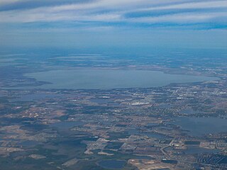
Lake Apopka is the fourth largest lake in the U.S. state of Florida. It is located 15 miles (24 km) northwest of Orlando, mostly within the bounds of Orange County, although the western part is in Lake County. Fed by a natural spring, rainfall and stormwater runoff, water from Lake Apopka flows through the Apopka-Beauclair Canal and into Lakes Beauclair and Dora. From Lake Dora, water flows into Lake Eustis, then into Lake Griffin and then northward into the Ocklawaha River, which flows into the St. Johns River. Multiple parks or nature trails are present around the lake including Magnolia Park, Lake Apopka Wildlife Drive, Ferndale Preserve, Oakland Nature Preserve, Dr. Bradford Memorial Park, and Newton Park, named for A. B. Newton.
Regarding the civil engineering of shorelines, soft engineering is a shoreline management practice that uses sustainable ecological principles to restore shoreline stabilization and protect riparian habitats. Soft Shoreline Engineering (SSE) uses the strategic placement of organic materials such as vegetation, stones, sand, debris, and other structural materials to reduce erosion, enhance shoreline aesthetic, soften the land-water interface, and lower costs of ecological restoration.

The Fairfield Osborn Preserve is a 450-acre nature reserve situated on the northwest flank of Sonoma Mountain in Sonoma County, California. There are eight plant communities within the property, oak woodland being the dominant type. Other communities include chaparral, Douglas fir woodland, native Bunch grass, freshwater marsh, vernal pool, pond and riparian woodland. The flora is extremely diverse including many native trees, shrubs, wildflowers, grasses, lichens and mosses. A diverse fauna inhabits this area including black-tailed deer, coyote, bobcat and an occasional mountain lion; moreover, there are abundant avifauna, amphibians, reptiles and insects.

Carbonera Creek is a 10.2-mile-long (16.4 km) watercourse in Santa Cruz County, California, that eventually flows to the San Lorenzo River.

A buffer strip is an area of land maintained in permanent vegetation that helps to control air quality, soil quality, and water quality, along with other environmental problems, dealing primarily on land that is used in agriculture. Buffer strips trap sediment, and enhance filtration of nutrients and pesticides by slowing down surface runoff that could enter the local surface waters. The root systems of the planted vegetation in these buffers hold soil particles together which alleviate the soil of wind erosion and stabilize stream banks providing protection against substantial erosion and landslides. Farmers can also use buffer strips to square up existing crop fields to provide safety for equipment while also farming more efficiently.

The Northern Basin and Range ecoregion is a Level III ecoregion designated by the United States Environmental Protection Agency (EPA) in the U.S. states of Oregon, Idaho, Nevada, Utah, and California. It contains dissected lava plains, rolling hills, alluvial fans, valleys, and scattered mountain ranges in the northern part of the Great Basin. Although arid, the ecoregion is higher and cooler than the Snake River Plain to the north and has more available moisture and a cooler climate than the Central Basin and Range to the south. Its southern boundary is determined by the highest shoreline of Pleistocene Lake Bonneville, which once inundated the Central Basin and Range. The western part of the region is internally drained; its eastern stream network drains to the Snake River system.

Freshwater biology is the scientific biological study of freshwater ecosystems and is a branch of limnology. This field seeks to understand the relationships between living organisms in their physical environment. These physical environments may include rivers, lakes, streams, ponds, reservoirs, or wetlands. Knowledge from this discipline is also widely used in industrial processes to make use of biological processes involved with sewage treatment and water purification. Water presence and flow is an essential aspect to species distribution and influences when and where species interact in freshwater environments.

Tamarix ramosissima, commonly known as saltcedarsalt cedar, or tamarisk, is a deciduous arching shrub with reddish stems, feathery, pale green foliage, and characteristic small pink flowers.

Riparian-zone restoration is the ecological restoration of riparian-zonehabitats of streams, rivers, springs, lakes, floodplains, and other hydrologic ecologies. A riparian zone or riparian area is the interface between land and a river or stream. Riparian is also the proper nomenclature for one of the fifteen terrestrial biomes of the earth; the habitats of plant and animal communities along the margins and river banks are called riparian vegetation, characterized by aquatic plants and animals that favor them. Riparian zones are significant in ecology, environmental management, and civil engineering because of their role in soil conservation, their habitat biodiversity, and the influence they have on fauna and aquatic ecosystems, including grassland, woodland, wetland or sub-surface features such as water tables. In some regions the terms riparian woodland, riparian forest, riparian buffer zone, or riparian strip are used to characterize a riparian zone.
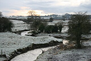
The Morell River is a river in County Kildare, Ireland, a tributary of the River Liffey.
The River Greese is a small, fast-flowing river in south-east, Ireland, and a tributary of the River Barrow.
Tully Stream is a stream in County Kildare, Ireland. It rises near Kildare town and ultimately drains into the Celtic Sea via other rivers.
The Mississippi Alluvial Plain is a Level III ecoregion designated by the Environmental Protection Agency (EPA) in seven U.S. states, though predominantly in Arkansas, Louisiana, and Mississippi. It parallels the Mississippi River from the Midwestern United States to the Gulf of Mexico.
Sri Lanka exhibits a remarkable biological diversity and is considered to be the richest country in Asia in terms of species concentration.

The Swan Coastal Plain Shrublands and Woodlands is a sclerophyll-woodland vegetation community that stretch from Kalbarri in the north to Busselton in the south, passing through Perth, in Western Australia. Situated on the Swan Coastal Plain, it is listed as Endangered under the Commonwealth Environment Protection and Biodiversity Conservation Act 1999. The woodlands also incorporate Perth–Gingin Shrublands and Woodlands.

The Tagus Basin is the drainage basin of the Tagus River, which flows through the west of the Iberian Peninsula and empties into Lisbon. It covers an area of 78,467 km2, which is distributed 66% on Spanish territory and 34% on Portuguese land (22,822 km2).

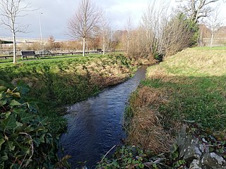
The Rye Water Valley/Carton Special Area of Conservation or SAC is a Natura 2000 site based along the Rye Water / River Rye in north County Kildare, Ireland. It is protected as an SAC since November 2018 due to the presence of a rare hydrogeological habitat at a site close to the River Rye, and the presence of protected species.

