(60 Members)"},"leader_name3":{"wt":"[[SPÖ]] 24, [[FPÖ]] 23, [[ÖVP]] 4,
[[Austrian Green Party|Green]] 4, WIFF 2, [[NEOS – The New Austria|NEOS]] 2"},"unit_pref":{"wt":"Metric"},"area_total_km2":{"wt":"44.46"},"population_footnotes":{"wt":"[http://www.statistik.at/web_de/statistiken/bevoelkerung/bevoelkerungsstand_jahres-_und_quartalswerte/bevoelkerung_zu_jahres-_quartalsanfang/023450.html Statistik Austria] {{webarchive|url=https://archive.today/20080530015219/http://www.statistik.at/web_de/statistiken/bevoelkerung/bevoelkerungsstand_jahres-_und_quartalswerte/bevoelkerung_zu_jahres-_quartalsanfang/023450.html |date=2008-05-30 }}"},"population_total":{"wt":"155998"},"population_as_of":{"wt":"2016-01-01"},"population_density_km2":{"wt":"auto"},"postal_code_type":{"wt":"[[Postal codes in Austria|Postal code]]"},"postal_code":{"wt":"A-1210"},"blank_name_sec1":{"wt":"Address of
District Office"},"blank_info_sec1":{"wt":"Am Spitz 1
A-1211 Wien"},"website":{"wt":"{{website|www.wien.gv.at/bezirke/floridsdorf/}}"}},"i":0}}]}" id="mwAg">21st District of Vienna in Austria
Floridsdorf | |
---|---|
21st District of Vienna | |
![]() Location of the district within Vienna | |
Country | Austria |
City | Vienna |
Government | |
• District Director | Georg Papai (SPÖ) |
• First Deputy | Ilse Fitzbauer (SPÖ) |
• Second Deputy | Karl Mareda (FPÖ) |
• Representation (60 Members) | SPÖ 24, FPÖ 23, ÖVP 4, Green 4, WIFF 2, NEOS 2 |
Area | |
• Total | 44.46 km2 (17.17 sq mi) |
Population (2016-01-01) [1] | |
• Total | 155,998 |
• Density | 3,500/km2 (9,100/sq mi) |
Postal code | A-1210 |
Address of District Office | Am Spitz 1 A-1211 Wien |
Website | www |
Floridsdorf (Austrian German: [ˈfloːrɪtsdɔrf] ; Viennese : Fluridsduaf) is the 21st district of Vienna (German : 21. Bezirk, Floridsdorf), located in the northern part of the city and comprising seven formerly independent communities: Floridsdorf, Donaufeld, Greater Jedlersdorf, Jedlesee, Leopoldau, Stammersdorf, and Strebersdorf.
Settlements were already present during the New Stone Age (4000 to 2000 BC). Stone axes and potsherds unearthed from that time indicate that the first settlers in the area were hunters. In the vicinity of Leopoldau, bronze weapons and jewelry provide evidence of subsequent settlement. Several of these items are now in the District Museum.
Around 500 BC, Celts entered the territory of present-day Floridsdorf, losing ground to the Romans as their empire expanded. The territory became a no-man's-land, or buffer zone, between the Romans and teutonic tribes, during a period when repeated battles were fought between the two peoples.
After the end of Roman rule, the territory attracted Lombards, Pannonian Avars, and Slavs. The Avars were later defeated by Charlemagne.
The Magyars had conquered the Pannonian Basin (present-day Hungary) by the end of the ninth century, and launched a number of plundering raids both westward and southward. The westward raids were stopped only with the Magyar defeat at the Battle of Lechfeld of 955, which led to a new political order in Western Europe centered on the Holy Roman Empire. Around 1000 AD, the Babenberg ruled in the area that is now modern Vienna. In 1014 came the first written mention of what today is Floridsdorf Jedlesee, then called Outcinesse (Sea of Uz).
For a long time, the Danube could be crossed only by ferry. In the year 1500, the first bridge was built. At the site of today's Floridsdorfer Haupstrasse, near the water park, the first wooden bridge (Tabor Bridge) was built. Another bridge, the Kuhbrückl, crossed a small arm of the Danube. At the fork of the main road to Bohemia and Moravia, the new settlement of Floridsdorf came into being.
Floridsdorf was first called "Am Spitz" and was later assigned to the Klosterneuburg Monastery. In 1786 Floridus Leeb, abbot of the monastery, transferred 26 properties to settler families. Through industrialization, Floridsdorf, originally an agricultural area, changed in a short time, so that on 8 May 1894 with the villages Donaufeld, Jedlesee and New Jedlersdorf, Floridsdorf was augmented to form a larger community. The steam tramway and the Northwest Railway have also contributed to industrialization. Today, a commemorative panel at Floridsdorf train station proclaims that on 23 November 1837 with the opening of the first section of the Emperor Ferdinand Northern Railway between Floridsdorf and Deutsch-Wagram, the age of the railways began in Austria.
From the middle of the 19th century, there were efforts to make Vienna reichsunmittelbar (self-governing under the Kaiser), separating it from the crown land of Austria at the Enns, Floridsdorf being envisaged as the future capital of Lower Austria.
By 1904, Floridsdorf was made up of the localities Jedlesee, Greater Jedlersdorf, Donaufeld, Leopoldau, Kagran, Hirschstetten, Stadlau, and Aspern. Then in 1910, Strebersdorf was also incorporated into Vienna. Through the establishment of the new district Donaustadt in 1938, Floridsdorf lost Kagran, Stadlau, Hirschstetten, Aspern and Lobau. During the Oil campaign of World War II, the Floridsdorf oil refinery and oil sidings were bombed by the Allies, in addition to a part of the southern Heinkel aviation firm's Heinkel-Süd military aircraft production facilities. In 1954, the borders of Lower Austria and Donaustadt were re-drawn and Stammersdorf incorporated.
North Floridsdorf is dominated by the southern foothills of Bisamberg. Since the summit of the Bisamberg hill, at 358 metres (1,175 ft), is today in Lower Austria, Floridsdorf's highest elevation is the Falkenberg, at 320 metres (1,050 ft).
The Danube marks Floridsdorf's southwestern border. Part of the New Danube and a section of the Danube Island fall within the district, while the wetlands immediately beyond form part of Döbling. Bridges spanning the Danube to Floridsdorf (listed by the Danube's direction of flow) include the Jedlesee bridge, the Vienna North Bridge, the Floridsdorf Bridge, the U6-Danube Bridge and the Brigittenauer Bridge. The northern section of the Old Danube flows through Floridsdorf. In 1992, the Marchfeld Canal, which crosses the district, was put into operation.
Floridsdorf comprises seven formerly independent communities: Floridsdorf, Donaufeld, Greater Jedlersdorf, Jedlesee, Leopoldau, Stammersdorf, and Strebersdorf, plus portions of two others.
The eponymous Floridsdorf sub-district is also the smallest in area. The largest is Stammersdorf, to the north. Stammersdorf borders Strebersdorf and Großjedlersdorf, consisting of the two communities Großjedlersdorf I and II. To the east, on the border of the 22nd district, are Leopoldau and Donaufeld. Jedlesee in the west is composed of Jedlesee and Schwarze Lackenau. In addition to these full sub-districts, Floridsdorf also contains parts of Kagran and Kaisermühlen, the greater portions of which lie in the district of Donaustadt.
Floridsdorf is also divided into 28 census districts. Although their names are identical or nearly identical to the corresponding sub-districts, the census districts of Donaufeld, Greater Jedlersdorf, Old Jedlesee, New Jedlesee, Leopoldau, Schwarzlackenau, Stammersdorf and Strebersdorf have distinct borders. Settlements and parcels of land have given their names to the census districts of Hirschfeld, Nordrandsiedlung, Großfeldsiedlung, Schottenfeld, Siemensstrasse, Jochberg, Donaufelder Gartnergebiet, Mühlschüttel, Bruckhaufen and Industriegelande Bahndreieck. The district of Autokader takes its name from the largest auto plant of the Habsburg monarchy (Austro-Fiat), while Gaswerk Leopoldau is named for the city gas works, opened in 1911. The remaining Floridsdorf census districts are named after streets: Stammersdorf-Brünner Straße, Leopoldauer Straße-Siemensstraße, Strebersdorf-Pragerstraße, Koloniestraße, Shuttleworthstraße, Floridsdorf-Brünnerstraße, Floridsdorf-Am Spitz und Donaufeld-Leopoldauer Straße.
Population Growth Data from Statistik Austria [2] |
Today's 21st district includes that area of Floridsdorf which, in 1869, along with its villages, had only 12,022 inhabitants. With the city limits located near Vienna, the population increased rapidly and showed, up to the First World War, very high growth rates. In 1910, Floridsdorf already had 62,154 inhabitants, its population since 1869 having more than quintupled. Since Floridsdorf after the First World War had a comparatively low population density compared to other districts, the local population rose more gradually. Apart from a brief decline around the Second World War, Floridsdorf's population has grown continuously, but with a significant fall from the 1990s on. At the beginning of 2007, there were 137,186 inhabitants - the third largest population among the Vienna districts. In terms of population density, Floridsdorf ranks only in the bottom quarter of the 23 Vienna municipalities, with 3,086 inhabitants per km2.
The population of Floridsdorf comprised, as of 2005, significantly more children, but also a slightly higher proportion of adults over 60, than the Vienna average. The number of children under 15 was 16.2% higher than for Vienna overall (14.6%). The proportion of the population aged 15 to 59 was 61.4% (Vienna: 63.4%), well below the mean, while the 20 to 34 age group showed a decrease. The proportion of inhabitants aged 60 or older was 22.5% (Vienna: 22.0%) slightly above the Vienna average. The gender distribution as of 2001 was 47.3% men and 52.7% women, the number of married people making up 43.0% compared to 41.2% in Vienna as a whole. [3] [4]
The proportion of foreign residents in Floridsdorf as of 2006 was 11% (Vienna citywide: 19.1%), [5] ranking fourth among the Vienna municipalities. In line with the country as a whole, growth of the foreign population in 2001 was 7.8%. The highest proportion of foreign residents in the district as of 2005, at 2.3%, was represented by Serbian and Montenegrin nationals. Another 1.2% were Turkish, 0.9% Polish and 0.6% German citizens. In 2001, a total of 15.4% of the district population was Austrian-born. Nearly 3.0% gave as their native language Serbian, 2.3% Turkish and 1.1% Croatian. [3] [6]
Floridsdorf has, with 53.9%, one of the highest populations of Roman Catholics in Vienna (Vienna citywide: 49.2%). There are 16 districts with Roman Catholic parishes, forming the City Deanery 21 (Archdiocese of Vienna). By contrast, the proportion of Muslims is 4.9% and Orthodox 3.0%. The proportion of Protestant residents stood at 4.4% in Vienna overall. 28.9% of the district's population as of 2001 professed no membership of a religious community, this being the highest such value within the Vienna municipality. A Further 4.9% of the population gave no religion or other confession. [3]
The District Office and the centre of Floridsdorf are located round Am Spitz, at the junction of Prager Straße (Prague Street) and Brünner Straße (Brno Street).
Parts of Floridsdorf were formerly villages, among which, for example, number Stammersdorf, Strebersdorf, and Leopoldau. Because of these sub-districts' origin as villages, Floridsdorf is characteristically rural, with most Heuriger taverns selling homegrown wine.
Bezirksvorsteher (political district heads), from 1945 | |
---|---|
Franz Koch (SPÖ) | 1945–1946 |
Franz Jonas (SPÖ) | 1946–1948 |
Ernst Theumer (SPÖ) | 1948–1959 |
Rudolf Hitzinger (SPÖ) | 1959–1964 |
Otmar Emerling (SPÖ) | 1964–1980 |
Kurt Landsmann (SPÖ) | 1980–1994 |
Heinz Lehner (SPÖ) | 1994–2014 |
Georg Papai (SPÖ) | 2014- |
The six panels of the Floridsdorf coat of arms comprise the crests of the previously independent municipalities Floridsdorf, Greater Jedlersdorf, Jedlesee, Leopoldau, Stammer, and Strebersdorf.
These six divisions of the Floridsdorf crest may be described as follows:
The Museum of Local History, now known as the District Museum, founded in 1960 in the Floridsdorf Mautner Schlössl (Prague Street) building, is devoted principally to the emergence of the Danube landscape, the beginning of steam navigation, railway history, and the history of some of the more ancient places in the area. The Museum of Harness and Saddlery, Horseshoes and Veterinary Orthopedics, closed in 2014, but pertaining to everything equine, housed a collection of bone specimens, saddles, horse and beef dishes and an exhibit on the development of horseshoeing from the Romans to the present day. The Vienna Fisheries Museum presents its visitors with information on local fishing through the ages, featuring an exhibition of rare specimens of native fish, aquariums, ancient writings and exhibits, fishing gear and fish-eating animals. In Jedlesee, at the former estate of Countess Anna Maria Erdődy, a memorial to Ludwig van Beethoven was established.
The choral group Harmony (exact name: Floridsdorfer Chorvereinigung "Harmony 1865"; founded: 1865) is a mixed choir, consisting of an average of 40 members. It gives regular performances, for example during Festival-week and Christmas, always with a program appropriate to the season. The choir makes occasional concert tours: to Kraków most recently, also to Rome and Tuscany.
Vienna is the capital, most populous city, and one of nine federal states of Austria. It is Austria's primate city, with just over two million inhabitants. Its larger metropolitan area has a population of nearly 2.9 million, representing nearly one-third of the country's population. Vienna is the cultural, economic, and political center of the country, the fifth-largest city by population in the European Union, and the most-populous of the cities on the Danube river.
Alsergrund is the ninth district of Vienna, Austria. It is located just north of the first, central district, Innere Stadt. Alsergrund was incorporated in 1862, with seven suburbs. As a central district, the area is densely populated. According to the census of 2001, there were 37,816 inhabitants over 2.99 square km.
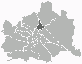
Leopoldstadt is the 2nd municipal district of Vienna in Austria. As of 1 January 2016, there are 103,233 inhabitants over 19.27 km2 (7 sq mi). It is situated in the heart of the city and, together with Brigittenau, forms a large island surrounded by the Danube Canal and, to the north, the Danube. It is named after Leopold I, Holy Roman Emperor. Due to its relatively high percentage of Jewish inhabitants before the Holocaust, Leopoldstadt gained the nickname Mazzesinsel. This context was a significant aspect for the district twinning with the New York City borough Brooklyn in 2007.
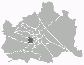
Meidling is the 12th district of Vienna. It is located just southwest of the central districts, south of the River Wien, west of the Gürtel belt, and east and southeast of Schönbrunn Palace. Meidling is a heavily populated urban area with many residential buildings, but also large recreational areas and parks. In sports, it is represented by the FC Dynamo Meidling. Former Chancellor of Austria Sebastian Kurz was born and raised in Meidling and his private residence is there.
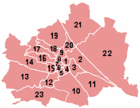
The districts of Vienna are the 23 named city sections of Vienna, Austria, which are numbered for easy reference. They were created from 1850 onwards, when the city area was enlarged by the inclusion of surrounding communities. Although they fill a similar role, Vienna's municipal districts are not administrative districts (Bezirke) as defined by the federal constitution; Vienna is a statutory city and as such is a single administrative district in its entirety.
The Innere Stadt is the 1st municipal district of Vienna located in the center of the Austrian capital. The Innere Stadt is the old town of Vienna. Until the city boundaries were expanded in 1850, the Innere Stadt was congruent with the city of Vienna. Traditionally it was divided into four quarters, which were designated after important town gates: Stubenviertel (northeast), Kärntner Viertel (southeast), Widmerviertel (southwest), Schottenviertel (northwest).
Hernals is the 17th district of Vienna, Austria . Hernals is in northwest Vienna. It was annexed in 1892 out of the townships of Hernals, Dornbach, and Neuwaldegg.
Döbling is the 19th district in the city of Vienna, Austria. It is located in the north of Vienna, north of the districts Alsergrund and Währing. Döbling has some heavily populated urban areas with many residential buildings, and borders the Vienna Woods. It includes some of the most expensive residential areas such as Grinzing, Sievering, and Neustift am Walde, and is home to many Heurigen taverns. There are some large Gemeindebauten, including Vienna's most famous, the Karl-Marx-Hof.
Donaustadt is the 22nd district of Vienna, Austria . Donaustadt is the eastern district of Vienna.
Liesing is the 23rd district of Vienna. It is on the southwest edge of Vienna, Austria.
Brigittenau is the 20th district of Vienna. It is located north of the central districts, north of Leopoldstadt on the same island area between the Danube and the Danube Canal. Brigittenau is a heavily populated urban area with many residential buildings.
Rudolfsheim-Fünfhaus is the 15th municipal District of Vienna, Austria. It is in central Vienna, west of Innere Stadt.
Heiligenstadt was an independent municipality until 1892 and is today a part of Döbling, the 19th district of Vienna, Austria.
Line U1 is a line on the Vienna U-Bahn metro system. Opened in 1978, it currently has 24 stations and a total length of 19.3 km (12.0 mi), from Oberlaa to Leopoldau. When the extension to Oberlaa was completed in 2017, the line became the longest on the network, surpassing the length of U6.
Wien Leopoldau is a railway station located in the Floridsdorf district of Vienna, Austria. Opened in 1912, it is owned and operated by the Austrian Federal Railways (ÖBB), and is served by both regional and S-Bahn trains.
Karl Biedermann was the commander of the Austrian Heimwehr, Major of Wehrmacht and a member of German resistance to Nazism.
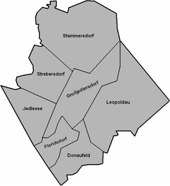
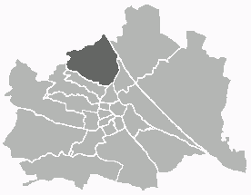
Jedlesee is a suburb of Floridsdorf, the 21st district of Vienna. An independent community until 1894, it was joined along with Leopoldau, Donaufeld, Floridsdorf and Neu Jedlesdorf to the greater Floridsdorf municipality, becoming part of Vienna in 1904. Jedlesee is most notable for being the site of the estate of Countess Anna Maria Erdődy, close friend and patron of Beethoven, who stayed there with her on numerous occasions between 1805 and 1818.
Johann Freiherr von O'Brien, Earl of Thomond (1775–1830), was an Austrian Major General with Irish ancestry, most noted for leading an action in the Battle of Schwarze Lackenau near Jedlesee, 1809, north of Vienna, against a superior force of Napoleon's troops in preparation for their defeat by Archduke Charles in the Battle of Aspern.
Oskar Icha was an Austrian sculptor who specialized in reliefs.
48°17′00″N16°24′44″E / 48.28333°N 16.41222°E