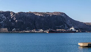
Londonderry is an unincorporated community located in Colchester County, Nova Scotia, Canada, formerly called Acadia Mines. A bustling iron ore mining and steel making town of some 5,000 in the late 19th century, the population today stands at around 200.
Upper Economy is a rural area of approximately 50 residents and 5 km2 located along Trunk 2 in western Colchester County, Nova Scotia. It stretches from along the north shoreline of the western end of Cobequid Bay north into the lower slopes of the Cobequid Mountains. Upper Economy is considered locally to be part of the rural community of Economy. It borders Little Bass River to the west and the former community of Pleasant Hills to the north.
Highway 104 in Nova Scotia, Canada, runs from Fort Lawrence at the New Brunswick border near Amherst to River Tillard near St. Peter's. Except for the portion on Cape Breton Island between Port Hawkesbury and St. Peter's, it forms the main route of the Trans-Canada Highway across the province.
Salt Springs is a small rural community located in the central-western part of Pictou County, Nova Scotia, Canada.

Trunk 2 is part of the Canadian province of Nova Scotia's system of Trunk Highways. The route runs from Halifax to Fort Lawrence on the New Brunswick border. Until the 1960s, Trunk 2 was the Halifax area's most important highway link to other provinces, and was part of a longer Interprovincial Highway 2 which ended in Windsor, Ontario. The controlled access Highway 102 and Highway 104 now carry most arterial traffic in the area, while Trunk 2 serves regional and local traffic.
Route 374 is a collector road in the Canadian province of Nova Scotia. It connects New Glasgow at Exit 24 of Nova Scotia Highway 104 with Sheet Harbour at Trunk 7. The highway runs through the Halifax Regional Municipality, Guysborough County & Pictou County.

Trunk 4 is part of the Canadian province of Nova Scotia's system of Trunk Highways. The route runs from Highway 104 exit 7 near Thomson Station to Glace Bay. Until the construction of the Trans-Canada Highway, Trunk 4 was a major traffic link in northern Nova Scotia and Cape Breton, and is still used on Cape Breton as an alternative to Highway 105. The highway was originally called the King's Highway, however, this name is no longer applied to the entire road. The only remaining historic section of the highway that maintains the name "King" is King's Road in Sydney.
The Wentworth Valley is a valley in the Cobequid Mountains of northwestern Nova Scotia, Canada. It comprises the lowest elevation pass through the Cobequids. It was named after the colonial governor John Wentworth (1792-1808).

The Nova Scotia peninsula is a peninsula on the Atlantic coast of North America. It is called Enmigtaqamu'g in the Mi'kmaw language.

The Cobequid Mountains, also sometimes referred to as the Cobequid Hills, is a Canadian mountain range located in Nova Scotia in the mainland portion of the province.
Masstown, formerly Cobequid, is a farming community located approximately 17 kilometres (11 mi) from Truro, Nova Scotia.
Port Hastings is an unincorporated settlement on Cape Breton Island, within the Municipality of the County of Inverness, Canada. The population in 2021 was 90.
Alma is an unincorporated rural community in the Canadian province of Nova Scotia, located in Pictou County. It is named after the Battle of Alma which occurred in 1854 during the Crimean War.
Mount Thom is a community in the Canadian province of Nova Scotia, located in Pictou County. It is at an elevation of 200m and is situated on Nova Scotia Trunk 4.
Aulds Cove is a community in the Canadian province of Nova Scotia, located in both Antigonish County and Guysborough County.
Beaver Brook is a small community in the Canadian province of Nova Scotia, located in Colchester County. It is a mainly rural community with one small saw mill. Beaver Brook is located on the 236 Highway just west of the community of Old Barns. The "Beaver Brook" runs through the community's farm fields and finally into the Cobequid Bay at the headwaters of the Bay of Fundy.
The Cobequid Pass is the name given to a 45 km (28 mi) tolled section of Nova Scotia Highway 104 between Thomson Station, Cumberland County and Masstown, Colchester County in the Canadian province of Nova Scotia. The section is a public–private partnership; the highway is owned by the Highway 104 Western Alignment Corporation, a Crown corporation of the Government of Nova Scotia, with a toll plaza operated under contract by Atlantic Highway Management Corporation Limited, a subsidiary of Aecon Concessions. The toll plaza is located near the halfway point in Londonderry. It opened in 1997.
The River Philip is a river contained entirely within Cumberland County, Nova Scotia, Canada.
The Chedabucto Fault is a fault that divides Mainland Nova Scotia from the Minas Basin in the west to Chedabucto Bay in the east into the Avalon zone in the north and the Meguma Zone in the south. The Avalon and Meguma Zones are different because they belonged to different land masses that were widely separated from one another. The Avalon Zone was a part of Laurasia, while the Meguma Zone was a part of Gondwana. It marks the southern margin of the Cobequid Mountains. The Cobequid-Chedabucto Fault Zone is the most prominent geological feature of Nova Scotia.

The old name Cobequid was derived from the Mi'kmaq word "Wagobagitk" meaning "the bay runs far up", in reference to the area surrounding the easternmost inlet of the Minas Basin in Nova Scotia, Canada, a body of water called Cobequid Bay.
